- Home
- :
- All Communities
- :
- Developers
- :
- ArcGIS API for Python
- :
- ArcGIS API for Python Questions
- :
- Re: Deep Learning prepare_data
- Subscribe to RSS Feed
- Mark Topic as New
- Mark Topic as Read
- Float this Topic for Current User
- Bookmark
- Subscribe
- Mute
- Printer Friendly Page
Deep Learning prepare_data
- Mark as New
- Bookmark
- Subscribe
- Mute
- Subscribe to RSS Feed
- Permalink
Hello,
I am following the example here for pixel classification:
Pixel-based Classification Workflow with | ArcGIS for Developers
In my case I am exporting data and labels from ArcPro, when i run:
data = prepare_data(data_path, batch_size=16)
I get error:
TypeError: int() argument must be a string, a bytes-like object or a number, not 'NoneType'''
What is the parameter settings needed in ArcPro to export data for this example?
API version: 1.7.0
ArcGIS Pro 2.4
Thank you,
- Mark as New
- Bookmark
- Subscribe
- Mute
- Subscribe to RSS Feed
- Permalink
If i export data as 'labelled tiles' i get error:
lib\site-packages\arcgis\learn\_data.py in prepare_data(path, class_mapping, chip_size, val_split_pct, batch_size, transforms, collate_fn, seed, dataset_type, resize_to, **kwargs) 357 358 if dataset_type is None and not has_esri_files:--> 359 raise Exception("Could not infer dataset type.") 360 361 if dataset_type != "Imagenet" and has_esri_files:Exception: Could not infer dataset type.
- Mark as New
- Bookmark
- Subscribe
- Mute
- Subscribe to RSS Feed
- Permalink
Try specifying the dataset_type. So for Classification tiles, add dataset_type='Classified_Tiles' to call the prepare_data function.
- Mark as New
- Bookmark
- Subscribe
- Mute
- Subscribe to RSS Feed
- Permalink
when i try to export 'Classified Tiles' thru export tool it gives error: ERROR 002091 Parameters are inconsistent.
- Mark as New
- Bookmark
- Subscribe
- Mute
- Subscribe to RSS Feed
- Permalink
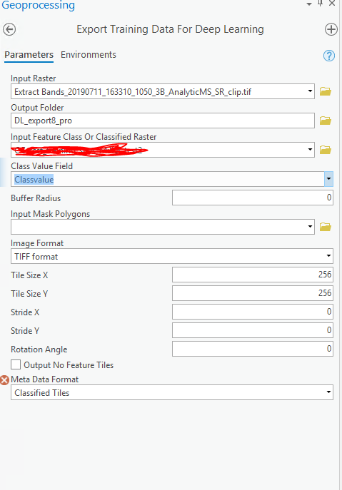
Can you post a screenshot of parameters you have supplied to the tool.
- Mark as New
- Bookmark
- Subscribe
- Mute
- Subscribe to RSS Feed
- Permalink
this gives the ERROR 002091 Parameters are inconsistent.
it's 3 band raster, TIFF or PNG still the same, sites were produced by the Training Sample Manager:

- Mark as New
- Bookmark
- Subscribe
- Mute
- Subscribe to RSS Feed
- Permalink
Can you check if there is any missing values in the ClassValue column .
- Mark as New
- Bookmark
- Subscribe
- Mute
- Subscribe to RSS Feed
- Permalink
I just went through this problem. Documentation says that exporting "classified_tiles" requires a classified raster (thematic) instead of feature class. So I had to do polygon to raster, then 'set raster properties'. Once I did that It let me export. Not sure if this is the correct way.
EDIT: looking at the 'extract building foot prints' here, my workflow with ultimately not work. I'm trying to prepare the data now for training and I'm getting errors.
- Mark as New
- Bookmark
- Subscribe
- Mute
- Subscribe to RSS Feed
- Permalink
You can follow the steps documented here https://developers.arcgis.com/python/sample-notebooks/extracting-building-footprints-from-drone-data...
- Mark as New
- Bookmark
- Subscribe
- Mute
- Subscribe to RSS Feed
- Permalink
Laurynas Gedminas Try to follow the methodology documented in this link to export training data for classified tiles here Extracting Building Footprints From Drone Data | ArcGIS for Developers .