- Home
- :
- All Communities
- :
- Developers
- :
- JavaScript Maps SDK
- :
- JavaScript Maps SDK Questions
- :
- See the result of a query on the map with Arcgis A...
- Subscribe to RSS Feed
- Mark Topic as New
- Mark Topic as Read
- Float this Topic for Current User
- Bookmark
- Subscribe
- Mute
- Printer Friendly Page
See the result of a query on the map with Arcgis Api JS
- Mark as New
- Bookmark
- Subscribe
- Mute
- Subscribe to RSS Feed
- Permalink
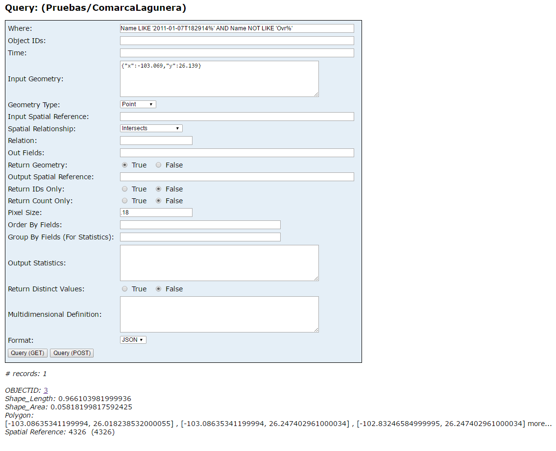
Let's say you enter these parameters. Which method of the "ArcGISImageServiceLayer" class can serve to display the image of the mosaic dataset? In the attached image the result is an image, but I do not know how to visualize it on the map.
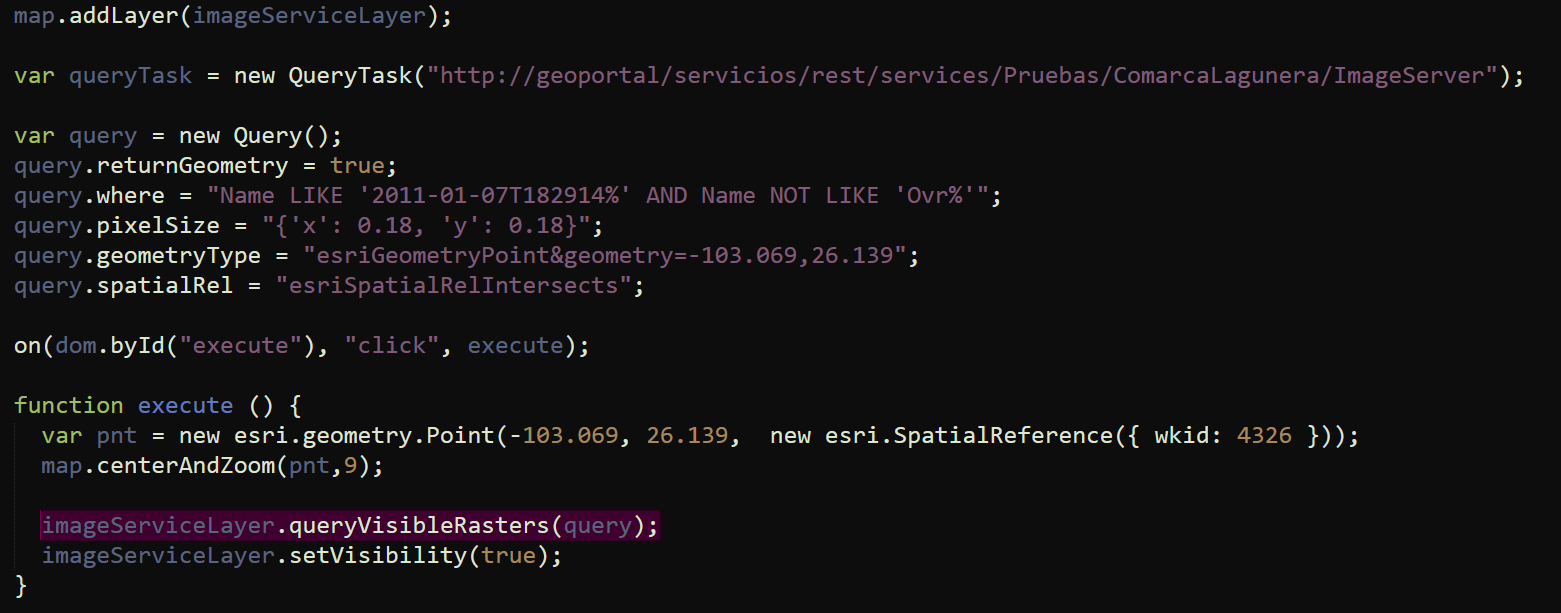
Part of my code is this, I used the "queryVisibleRasters" method to try to visualize it, but it did not work, any suggestions are very well received, thanks!
|
Solved! Go to Solution.
Accepted Solutions
- Mark as New
- Bookmark
- Subscribe
- Mute
- Subscribe to RSS Feed
- Permalink
Marina,
I think you are thinking that the queryVisibleRasters method is suppose to just return the raster that intersects or sets the definition expression or something. What it actually does is return the geometry of the raster footprint that intersects the provided geometry. Here is a sample of what it actually does:
<!DOCTYPE html>
<html>
<head>
<meta http-equiv="Content-Type" content="text/html; charset=utf-8">
<meta name="viewport" content="initial-scale=1, maximum-scale=1,user-scalable=no">
<title>Simple Image Service</title>
<link rel="stylesheet" href="https://js.arcgis.com/3.18/esri/css/esri.css" />
<style>
html, body, #map { height: 100%; width: 100%; margin: 0; padding: 0; }
</style>
<script src="https://js.arcgis.com/3.18/"></script>
<script>
var map, gl, symbol;
require([
"esri/map", "esri/layers/ArcGISImageServiceLayer", "esri/tasks/query", "esri/geometry/Point", "esri/layers/GraphicsLayer",
"esri/symbols/SimpleFillSymbol", "esri/symbols/SimpleLineSymbol", "esri/Color", "esri/layers/ImageServiceParameters", "dojo/on", "dojo/domReady!"
], function(
Map, ArcGISImageServiceLayer, Query, Point, GraphicsLayer,
SimpleFillSymbol, SimpleLineSymbol, Color, ImageServiceParameters, on
) {
map = new Map("map", {
basemap: "topo",
center: [-79.40, 43.64],
zoom: 12
});
gl = new GraphicsLayer();
symbol = new SimpleFillSymbol(SimpleFillSymbol.STYLE_SOLID, new SimpleLineSymbol(SimpleLineSymbol.STYLE_DASHDOT, new Color([255,0,0]), 2),new Color([255,255,0,0.25]));
var params = new ImageServiceParameters();
params.noData = 0;
var imageServiceLayer = new ArcGISImageServiceLayer("https://sampleserver6.arcgisonline.com/arcgis/rest/services/Toronto/ImageServer", {
imageServiceParameters: params,
opacity: 0.75
});
map.addLayers([gl, imageServiceLayer]);
on(imageServiceLayer, "update-end", function(){
var query = new Query();
query.returnGeometry = true;
query.pixelSize = "{'x': 0.18, 'y': 0.18}";
query.geometry = new Point(-79.40, 43.64);
query.spatialRelationship = Query.SPATIAL_REL_INTERSECTS;
imageServiceLayer.queryVisibleRasters(query, null, function(result){
gl.add(result[0].setSymbol(symbol));
});
imageServiceLayer.setVisibility(true);
});
});
</script>
</head>
<body>
<div id="map"> </div>
</body>
</html>
- Mark as New
- Bookmark
- Subscribe
- Mute
- Subscribe to RSS Feed
- Permalink
Marina,
Where is your code to handle the returned promise from the queryVisibleRasters?
- Mark as New
- Bookmark
- Subscribe
- Mute
- Subscribe to RSS Feed
- Permalink
Is stored in the query object:
query.returnGeometry = true;
query.where = "Name LIKE '2011-01-07T182914%' AND Name NOT LIKE 'Ovr%'";
query.pixelSize = "{'x': 0.18, 'y': 0.18}";
query.geometryType = "esriGeometryPoint&geometry=-103.069,26.139";
query.spatialRel = "esriSpatialRelIntersects";
- Mark as New
- Bookmark
- Subscribe
- Mute
- Subscribe to RSS Feed
- Permalink
Marina,
No, I am talking about the callback function that you would use to do something with the returned rasters.
The queryVisibleRasters =
Returns the rasters that are visible in the area defined by the geometry (required to be point or polygon) in the query parameter.
- Mark as New
- Bookmark
- Subscribe
- Mute
- Subscribe to RSS Feed
- Permalink
Hi, Robert
I'm taking the queryVisibleRasters to display on the map the result of the query, Sorry if I do not understand your last comment. Need something in my code? At the push of a button I call this method
- Mark as New
- Bookmark
- Subscribe
- Mute
- Subscribe to RSS Feed
- Permalink
Marina,
I think you are thinking that the queryVisibleRasters method is suppose to just return the raster that intersects or sets the definition expression or something. What it actually does is return the geometry of the raster footprint that intersects the provided geometry. Here is a sample of what it actually does:
<!DOCTYPE html>
<html>
<head>
<meta http-equiv="Content-Type" content="text/html; charset=utf-8">
<meta name="viewport" content="initial-scale=1, maximum-scale=1,user-scalable=no">
<title>Simple Image Service</title>
<link rel="stylesheet" href="https://js.arcgis.com/3.18/esri/css/esri.css" />
<style>
html, body, #map { height: 100%; width: 100%; margin: 0; padding: 0; }
</style>
<script src="https://js.arcgis.com/3.18/"></script>
<script>
var map, gl, symbol;
require([
"esri/map", "esri/layers/ArcGISImageServiceLayer", "esri/tasks/query", "esri/geometry/Point", "esri/layers/GraphicsLayer",
"esri/symbols/SimpleFillSymbol", "esri/symbols/SimpleLineSymbol", "esri/Color", "esri/layers/ImageServiceParameters", "dojo/on", "dojo/domReady!"
], function(
Map, ArcGISImageServiceLayer, Query, Point, GraphicsLayer,
SimpleFillSymbol, SimpleLineSymbol, Color, ImageServiceParameters, on
) {
map = new Map("map", {
basemap: "topo",
center: [-79.40, 43.64],
zoom: 12
});
gl = new GraphicsLayer();
symbol = new SimpleFillSymbol(SimpleFillSymbol.STYLE_SOLID, new SimpleLineSymbol(SimpleLineSymbol.STYLE_DASHDOT, new Color([255,0,0]), 2),new Color([255,255,0,0.25]));
var params = new ImageServiceParameters();
params.noData = 0;
var imageServiceLayer = new ArcGISImageServiceLayer("https://sampleserver6.arcgisonline.com/arcgis/rest/services/Toronto/ImageServer", {
imageServiceParameters: params,
opacity: 0.75
});
map.addLayers([gl, imageServiceLayer]);
on(imageServiceLayer, "update-end", function(){
var query = new Query();
query.returnGeometry = true;
query.pixelSize = "{'x': 0.18, 'y': 0.18}";
query.geometry = new Point(-79.40, 43.64);
query.spatialRelationship = Query.SPATIAL_REL_INTERSECTS;
imageServiceLayer.queryVisibleRasters(query, null, function(result){
gl.add(result[0].setSymbol(symbol));
});
imageServiceLayer.setVisibility(true);
});
});
</script>
</head>
<body>
<div id="map"> </div>
</body>
</html>
- Mark as New
- Bookmark
- Subscribe
- Mute
- Subscribe to RSS Feed
- Permalink
Thank you, Robert.
- Mark as New
- Bookmark
- Subscribe
- Mute
- Subscribe to RSS Feed
- Permalink
Don't forget to mark this question as answered by clicking on the "Correct Answer" link on the reply that answered your question.