- Home
- :
- All Communities
- :
- Products
- :
- ArcGIS Online
- :
- ArcGIS Online Questions
- :
- Latlong insertion to ArcMap
- Subscribe to RSS Feed
- Mark Topic as New
- Mark Topic as Read
- Float this Topic for Current User
- Bookmark
- Subscribe
- Mute
- Printer Friendly Page
Latlong insertion to ArcMap
- Mark as New
- Bookmark
- Subscribe
- Mute
- Subscribe to RSS Feed
- Permalink
- Report Inappropriate Content
Can anyone help please? I received the following "n.29.14758 w.82.11479 n/b n.29.14750 w.82.11479 s/b n.29.14549 w.82.11544 24x30 signs" from the field crew staff. how do I insert it to ArcMap to fall into the correct location?
Regards,
Rudy
- Mark as New
- Bookmark
- Subscribe
- Mute
- Subscribe to RSS Feed
- Permalink
- Report Inappropriate Content
Hi Rudy,
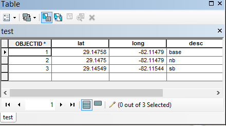
One way to do this is to create a table with fields lat, long, and a description. The longitude would be negative numbers since they are west.
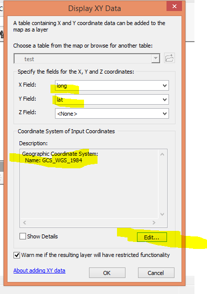
Then, if you right click on the table, you can select "Display XY Data". It should, by default, select the lat and long fields. If you called the fields some other name, select the appropriate field in the pull-down. I'm assuming the coordinates were collected in WGS84, but you can adjust that as needed.
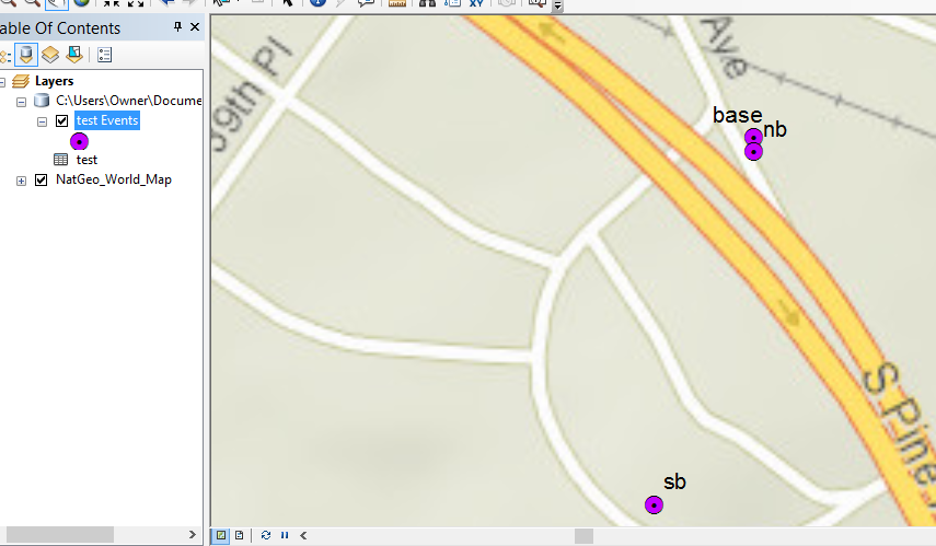
Based on these steps, this is the general area the points landed for me. If this location doesn't look at all familiar, than my procedures and assumptions may be off. But that is a general process for displaying x/y values from a file. This Display XY is a temporary file, so make sure to right click and save as a feature class or shape file, as needed. I hope this helps.
By the way, I created a table in the default file geodata in ArcMap, but this can also be done by creating the table in an Excel spread sheep of other file and importing the file int o ArcMap, and using the Display XY Data from that file. May different ways to do this, my sample is just one option.
- Mark as New
- Bookmark
- Subscribe
- Mute
- Subscribe to RSS Feed
- Permalink
- Report Inappropriate Content
Another nifty option if you just have a few of these is the xy button in ArcMap. Helpful for once offs like your couple of emailed points.