Turn on suggestions
Auto-suggest helps you quickly narrow down your search results by suggesting possible matches as you type.
Cancel
- Home
- :
- All Communities
- :
- Products
- :
- Geoprocessing
- :
- Geoprocessing Questions
- :
- Feature to Raster issue
Options
- Subscribe to RSS Feed
- Mark Topic as New
- Mark Topic as Read
- Float this Topic for Current User
- Bookmark
- Subscribe
- Mute
- Printer Friendly Page
Feature to Raster issue
Subscribe
1178
2
05-03-2013 11:07 AM
by
Anonymous User
Not applicable
05-03-2013
11:07 AM
- Mark as New
- Bookmark
- Subscribe
- Mute
- Subscribe to RSS Feed
- Permalink
Original User: emyoung90
Hi-
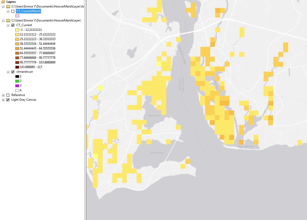
I have a vector shapefile with an associated attribute table, and I'm trying to convert it into a raster that is classified by the values in one of the attribute table columns.
From what I can tell (based off of what I know and what I've read), all I should have to do is go to Conversion tools>>To Raster>>Feature to raster, and enter in my shapefile as the input feature, the desired attribute column as my "field", and then name the output raster. The output cell size is generated automatically, and it has a value of ~621, despite the shapefile being at a pretty fine scale. I've tried saving it in a geodatabase, and tried saving it in another file as a .tif, but no matter what I do, the output file has HUGE pixels that do not accurately represent the data, and the pixels are divided by value into 9 different float classes, even though there are only 4 different values in the input attribute, and they are discrete integers. I've included a screen shot of what the original shapefile looks like, and the appearance of the output file.
Can anyone tell what's going on here? I would appreciate any help you can give. Thanks!
Emma
Hi-
I have a vector shapefile with an associated attribute table, and I'm trying to convert it into a raster that is classified by the values in one of the attribute table columns.
From what I can tell (based off of what I know and what I've read), all I should have to do is go to Conversion tools>>To Raster>>Feature to raster, and enter in my shapefile as the input feature, the desired attribute column as my "field", and then name the output raster. The output cell size is generated automatically, and it has a value of ~621, despite the shapefile being at a pretty fine scale. I've tried saving it in a geodatabase, and tried saving it in another file as a .tif, but no matter what I do, the output file has HUGE pixels that do not accurately represent the data, and the pixels are divided by value into 9 different float classes, even though there are only 4 different values in the input attribute, and they are discrete integers. I've included a screen shot of what the original shapefile looks like, and the appearance of the output file.
Can anyone tell what's going on here? I would appreciate any help you can give. Thanks!
Emma
2 Replies
05-03-2013
11:47 AM
- Mark as New
- Bookmark
- Subscribe
- Mute
- Subscribe to RSS Feed
- Permalink
You should be able to assign a cell size in FeatureToRaster;
you don't have to accept the default value
(which is supposedly the shortest dimension divided by 250)
The classes displayed too are just a guess by ArcMap as to how it should be shown.
That can be changed interactively, or by assigning a symbolization you have saved
in a raster layer file.
you don't have to accept the default value
(which is supposedly the shortest dimension divided by 250)
The classes displayed too are just a guess by ArcMap as to how it should be shown.
That can be changed interactively, or by assigning a symbolization you have saved
in a raster layer file.
by
Anonymous User
Not applicable
05-06-2013
08:35 AM
- Mark as New
- Bookmark
- Subscribe
- Mute
- Subscribe to RSS Feed
- Permalink
Original User: emyoung90
Great, I got it to work, thanks!
I'm having a different problem now, though... after I produce the raster, if I try to open the saved file in another arcmap document, the file will load to the table of contents, and the attribute information is available, but the map won't load/show up on the actual map itself. Any ideas as to what issue I'm having here? Thanks again.
Emma