- Home
- :
- All Communities
- :
- User Groups
- :
- Web AppBuilder Custom Widgets
- :
- Questions
- :
- Re: Esearch widget duplicating label on map after ...
- Subscribe to RSS Feed
- Mark Topic as New
- Mark Topic as Read
- Float this Topic for Current User
- Bookmark
- Subscribe
- Mute
- Printer Friendly Page
Esearch widget duplicating label on map after point selection
- Mark as New
- Bookmark
- Subscribe
- Mute
- Subscribe to RSS Feed
- Permalink
Hello!
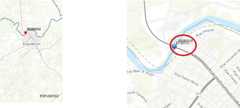
I'm using the eSearch widget on a layer that has labels (code number 8 digits). When zooming in the layer, without applying the esearch filter, the label appears correctly, as in the images on the left which is attached. After I make a selection by drawing a circle on the layer, the selected points have the blue symbol, and end up doubling the 8 digit label. I can't understand why. I imagine that you should be placing the label, once for each symbol at the same point. If so, does anyone have any idea how to solve this problem? My client is complaining about this.
Thank you!
Gilberto.
Solved! Go to Solution.
Accepted Solutions
- Mark as New
- Bookmark
- Subscribe
- Mute
- Subscribe to RSS Feed
- Permalink
Robert,
I can see that option, yes. But I managed to find the problem. It is even a tip if someone goes through the same situation. The layer was configured with the labels since the assembly in mxd. And inside portal too. The solution I found was to ask the geoprocessing analyst, remove the labels from the layer in mxd and republish the service. There inside the portal for arcgis, I removed the old layer, added the new one without the labels in mxd, and configured the label through the portal. Now the label is no longer duplicated.
Thank you for your help and attention.
Thank you!
Gilberto.
- Mark as New
- Bookmark
- Subscribe
- Mute
- Subscribe to RSS Feed
- Permalink
Gilberto,
If you clear the eSearch results does the second label go away?
- Mark as New
- Bookmark
- Subscribe
- Mute
- Subscribe to RSS Feed
- Permalink
Hi!

Yes, clearing the results, the second label disappears, along with the symbol used to mark the points of the results. There is only one label, that of the normal dot, like the one on the left.  Thank you! Gilberto.
- Mark as New
- Bookmark
- Subscribe
- Mute
- Subscribe to RSS Feed
- Permalink
Gilberto,
I am have trouble reproducing this. Can you provide the config.json for the eSearch widget that you are using in this app?
- Mark as New
- Bookmark
- Subscribe
- Mute
- Subscribe to RSS Feed
- Permalink
Robert,  Follow the esearch widget config.json. I didn't find an option to attach the file,
so I pasted the code. Excuse me!  Thank you!
{ "layers": [ { "name": "Filtrar Estações Monitoradas", "url": "https://hsig.sema.rs.gov.br/arcgis/rest/services/1_RSAGUAS/Mapa_basico_SIGRSAGUA/FeatureServer/1", "definitionexpression": "", "spatialsearchlayer": false, "export2Csv": true, "export2Geo": false, "export2FC": false, "zoomScale": 10000, "forceZoomScale": false, "shareResult": true, "addToAttrib": true, "expressions": { "expression": [ { "alias": "Região Hidrográfica", "textsearchlabel": "", "values": { "value": [ { "fieldObj": { "name": "REG_H", "label": "Região Hidrográfica", "shortType": "string", "type": "esriFieldTypeString" }, "valueObj": { "value": "" }, "prompt": "Região Hidrográfica is", "textsearchhint": "Informe a região hidrográfica", "sqltext": "Upper(REG_H) = Upper('[value]')", "operation": "stringOperatorIs" } ] } }, { "alias": "Bacia Hidrográfica", "textsearchlabel": "", "values": { "value": [ { "fieldObj": { "name": "BH", "label": "Bacia Hidrográfica", "shortType": "string", "type": "esriFieldTypeString" }, "valueObj": { "value": "" }, "prompt": "Bacia Hidrográfica is", "textsearchhint": "Informe a bacia hidrográfica", "sqltext": "Upper(BH) = Upper('[value]')", "operation": "stringOperatorIs" } ] } }, { "alias": "Recurso Hídrico", "textsearchlabel": "", "values": { "value": [ { "fieldObj": { "name": "RH", "label": "Recurso Hídrico", "shortType": "string", "type": "esriFieldTypeString" }, "valueObj": { "value": "" }, "prompt": "Recurso Hídrico", "textsearchhint": "Informe o recurso hídrico", "sqltext": "Upper(RH) = Upper('[value]')", "operation": "stringOperatorIs" } ] } }, { "alias": "Município", "textsearchlabel": "", "values": { "value": [ { "fieldObj": { "name": "MUNICIPIOS", "label": "Municípios", "shortType": "string", "type": "esriFieldTypeString" }, "valueObj": { "value": "" }, "prompt": "Municípios", "textsearchhint": "Informe o nome do município", "sqltext": "Upper(MUNICIPIOS) LIKE Upper('%[value]%')", "operation": "stringOperatorContains" } ] } }, { "alias": "Código Estação", "textsearchlabel": "", "values": { "value": [ { "fieldObj": { "name": "CODIGO", "label": "Código Estação", "shortType": "string", "type": "esriFieldTypeString" }, "valueObj": { "value": "" }, "prompt": "Código Estação", "textsearchhint": "Informe o código da estação monitorada", "sqltext": "Upper(CODIGO) = Upper('[value]')", "operation": "stringOperatorIs" } ] } } ] }, "titlefield": null, "fields": { "all": false, "field": [ { "name": "REG_H", "alias": "Região Hidrográfica" }, { "name": "BH", "alias": "Bacia Hidrográfica" }, { "name": "RH", "alias": "Recurso Hídrico" }, { "name": "MUNICIPIOS", "alias": "Municípios" }, { "name": "CODIGO", "alias": "Código Estação" } ] }, "links": { "link": [] }, "relates": { "relate": [] }, "orderByFields": [ "CODIGO ASC" ], "showattachments": false, "disablePopups": true, "layersymbolfrom": "layer", "symbology": { "angle": 0, "xoffset": 0, "yoffset": 0, "type": "esriPMS", "url": "http://hsig.sema.rs.gov.br/portal/portalimages/Symbols/Basic/BlueBeacon.png", "imageData": "iVBORw0KGgoAAAANSUhEUgAAAEAAAABACAYAAACqaXHeAAAAAXNSR0IArs4c6QAAAARnQU1BAACxjwv8YQUAAAAgY0hSTQAAeiYAAICEAAD6AAAAgOgAAHUwAADqYAAAOpgAABdwnLpRPAAACgtJREFUeF7tWwlUVEcWFVBZQwQVlHYZ97gMRNGJIyGJS1wweuK4yybu4hJQUXFB44pGjRMFZQeRCIIgSBAXNhWFcUEc0dhxTVBRHFBhHAeNd97r9Of8w8Q0YPfvzol1zj31m19V771b7/9f9erRoMHb8pYBbTFgRoIdtCVcF+T2JSVOE/R0QRlt6DCVhL4iWGtDuC7I/IqUAOGvuqCMNnSIURIwShvCdUFmvJKACbqgjDZ02P+WgF/eAWO0wb4uyBQ8YKwuKKNKh8808LZOUz4CzqqE1/H+RGrfuY59VDbnT9VLgj+hocrWtWvAY/Lst6pdc5Wt2lOLTEIRgVeZai9sPD+zxwm6tngZQjo9VOqnsXUFz3yWUshlqtvUkeKOyhlfRXUUgd8BAnbT9QLCYEKzOo7LXsTeyZOzsI5969ycZ/6KUhjXqkhoTW18CGcIz5X9WNHfQindTySMJjRSoSEb/7NyvMA6W1PPDmy0mIS2vzIOE7WJ8C/BWOsWLTDMaTgWLfXFjuAwhMXEITg6Frv3xGLt1h1wm+EJ+74OMDQyEpPzT+rv/ho9xTMfVE9b6t1NTMJNGqWpaKRJdP2TYPiIESMQfyARJY/KIC6v6EcV4RnhKYHv3qwEjhbI4bNuCzr3sBMTcYzG6y6SMVTkRZIbL+jBJHxPCCEYKLFTUGzosGE4nZdXbfNzurpR/gKni/+D1B8qkXC1AvGE/VcqkCKvRObtZzhXUgU5sXHrBfCP+8/htyMSLVq1FYh4TGPzJ45LO8IlQnS9p1BNHd9VjmNMdQobb2pqisDAwGrDy56/Qtbtf2PXuTKsOVGK5VkPsTyTwDVhhRJ+2aXYcOoRdlO7lO8rcOZeFS5VAIcuP8CgUZPE3iC86PhTp68mO954mENsvEwmQ27uaYXx7OKn7lRi08mH8Dl6H0uP3ceKjBL4Zb4efN+X2i07XoKtuaVIKHqMnLsvkV0CeCxZLybB8401VuMA/PZVGF9UVKQw/snzlwg//whe3xXDJ70Yy47erRN8qT3343pX/kOkXKsA8YJpK78WSOBACr8HtF74TQxjY2OcyctXGP+wsgr+OffgmXIbPod/fCMsSvsR3ql3sInG23epHAdvAyOnLxJIKCHZWl2Q8YKFlUDgrl0K48ufvcD6zGLMTLyBBYduwVtNmJd8C+syfkLUhTJEFFag6wf9BRI4qKK1wt95DBw4UGH8i5+BgNx7mBInx/ykG5iXdF2t8Ey8jnXH7yC04ClWxOXB0MRUIIGDq5KXFiTxiYGBAfLPnlcQcFxeBrdvr2JWvByzE9SPmTSuJ427kUjYeb4S/V3mCwTw10fywp8iONHKTnjuvZPkcI+5gumxVzWGKd9egVeiHP7Z97EgJp+8wIxJeEFQ+/ZXFaP5TEBcQqKCgKTCBxgbVgiPvZc1isk8fsxlLE6WY3XmA3T/5HPBC3xVKazO+7zvrmpuZYXi0nJUVL3C0uRrREABXKIKNQ7nyELM3HcZvkfu4bPFOwUCeJcqWRnHsz9kmBNe0uxfLK7AxLALGBd6HhOo1jTGh16Aa2QB5h2QwyUgAw0NjZkE3nRZSMXAGibAy2fpL+5/8T6G78zDmKCzkmFs8FlMib4EdyLCsnUnwQvspSKAgxnYujMI/yUCdmTewKdf5+LzwDzpEJCHiaHn4BpdBBvbDwUCRtaXAHPqyN9SPqvbTODFhThaI1wLoaYEJiAgfC+e0oJ/XepV9N9yAsO/yZUUfws8g/GRRZDZDxIIEA5YvF+jfzj9fSWBV6/dCNXBlo/oRzYbpQIeSoYV4eztwVEopQ39quQiOPpnYci2E5Ji+N9PYVRIIVq+P0DQm+MQXE6osOMx3Y8gWNX0GF5X8yzzWR2zVBNC9FZxpLVlVySKKZqxPPES+q0/joFfZUmKwVuz4RR4HtZ21cti4XyBA6RzCXOU9WSlLcOptiW8U9Pwuv7mACYWr9mMm0/oEUgpQp8vj+LjjRmSov+mLAzYchIWHXsJHsCGS1IWMQGjXaehqPQlAjLk6L0qHf3WHoWDhHDckAmH1WkwsmjJBHBUuKsk1pOQT5mAbu/3Rs4PZYjLvwPHtUfQ2y8NH6w+LBn6bciC3dxg6OkbMAF3CEZSEcAB0PLGhkYI/S4P6UWlGLcjB92WJKPXilRJYL8yFX03nkAbpzmC+/OLWdJykL3A3dsPR649hV9CAbosSoLt0mTY+moedstT0NMvHWZtugsEuEpqPQnjLwVk7Toh8uQNhOVcx8D1h9HBKx7dfRLRTYPg8W1XpqO962bB+Eeki2TLYIFoQ7rgkDjcFvsjKr8EPnvz0fGL/ejotR+dveM1hi4LE9DVNw1mHf8iEMCLN60UFyagSTNrfBl3BtvSr2H0tmOwmRWDdvNi0V4TmL8PnZakocXIxeKzAg7OaKVwfl8Ok2Dr6ERL4mtYHnsOH69OgdX0aLSeHYM2nurFn7wOoNW0YBiYWQoEeGnFcpHQLnRdwSR8NGEulh64ijnhuei7LAnNpkbCevoetJwRTeC6/rChvrI5cZARqYayboLxGSRXJ5IseROiUOpD54WYFVUA98AcOKxIhPW0SFhMDkezKRFoToTUB1ZTI2A9O5a8ag8M2/URjOfvvkzbsy+Wz2f7CuV6DHXH2O3ZGEP4xO8gOszZC0v3MJi7huJdt1A0oWuLWsLSIxxNZ+6HxcRv0MimeuY5+GGnK8YPI0WETRJvQBQkWHXpAwevEAzyz8RHq1JhuyAWrWdEoal7KMxdQvCOczDMCFz/H1yCiawQmE+JhrlHNEz6z4O+qYUw87do/J5K4wdQLXkwVEy84lSIwJ/DJsobvOO6y383aGwMmcNY9Ji1G3a0SuxOC6UOc/dBNj0KzSeTF7iRkc5BMJsUBJOJQTCeFAxjlzCYuEfD2DkMRkN8YdDGXrxFPyIim43ne9cJqpI0NOIs4swMPqI2FUmxoes9gjfoNzaB+XuOsBo8H9YTtqK5ewgsPaJg7r4HJq6RMHKOQKPxQWg0ejsaDV0JA/sJ0LfqLDacc3+8aljBuQJypYzaZKqolQSx8b+VnOBIUjnVheP2CoP0GhrCwKIVDGz+DP3W9tBv1Qt6sp7Qs+qCBqbN0EBPX2z4PerDp0+cZvNrpWamiiSewElMQk5ObTMzOPzEcXv+bPGy9XWRpyq6x894LMGNIM46ed0MiknghIkmap3qGoO1pd/lSgMC6inIkvr1InAAUxxx4mDGewROtKhrYRIuKvU6WNfOtW3PC448pRAOiOha4c3QAaV+HBRVe+HFDrsYB1DVVYTorToTG78g5QoJ6so+rbaV3VNdKbLCoJrKFW5JAhg6X35X2eKaYPMtAcqX1u/i/wU04QGKIzYCnzb/IQuf1TEBvH/4Q5ZVSgJ0Zmsr9Szws8/RpDc+q5NacXXJ46OsCHUNVt9x/gfKBxqkELQR+wAAAABJRU5ErkJggg==", "contentType": "image/png", "width": 18, "height": 18 } } ], "bufferDefaults": { "autoZoom": true, "addtolegend": false, "bufferUnits": { "bufferUnit": [ { "name": "UNIT_FOOT", "label": "Feet" }, { "name": "UNIT_STATUTE_MILE", "label": "Miles" }, { "name": "UNIT_METER", "label": "Meter" } ] }, "bufferDefaultValue": 5, "bufferWKID": 102003, "simplefillsymbol": { "color": [ 155, 187, 89, 128 ], "outline": { "color": [ 115, 140, 61, 255 ], "width": 1.5, "type": "esriSLS", "style": "esriSLSSolid" }, "type": "esriSFS", "style": "esriSFSSolid" } }, "spatialrelationships": { "spatialrelationship": [ { "label": "entirely contained in", "name": "esriSpatialRelContains" }, { "label": "intersected by", "name": "esriSpatialRelIntersects" }, { "label": "intersected by envelope of", "name": "esriSpatialRelEnvelopeIntersects" } ] }, "graphicalsearchoptions": { "enableextentselect": true, "enablecircleselect": true, "enablepolyselect": true, "showmultigraphicsgraphicaloption": true, "showaddtolerancegraphicaloption": true, "showaddsqltextgraphicaloption": true, "showbuffergraphicaloption": true, "buffercheckedbydefaultgraphicaloption": false, "multipartgraphicsearchchecked": false, "addpointtolerancechecked": false, "toleranceforpointgraphicalselection": 6, "keepgraphicalsearchenabled": true, "autoactivatedtool": "circle" }, "symbols": { "simplemarkersymbol": null, "picturemarkersymbol": { "angle": 0, "xoffset": 0, "yoffset": 0, "type": "esriPMS", "url": "https://vaio_svt13115fb:3344/webappbuilder/apps/4/widgets/eSearch/https://vaio_svt13115fb:3344/webap...", "width": 20.00025, "height": 20.00025 }, "simplelinesymbol": { "color": [ 255, 0, 0, 204 ], "width": 2.25, "type": "esriSLS", "style": "esriSLSSolid" }, "simplefillsymbol": { "color": [ 155, 187, 89, 128 ], "outline": { "color": [ 115, 140, 61, 255 ], "width": 1.5, "type": "esriSLS", "style": "esriSLSSolid" }, "type": "esriSFS", "style": "esriSFSSolid" } }, "resultFormat": { "attTitlesymbol": { "bold": false, "italic": true, "underline": false, "color": [ 0, 0, 0, 1 ] }, "attValuesymbol": { "bold": false, "italic": false, "underline": false, "color": [ 0, 0, 0, 255 ] } }, "initialView": "text", "selectfilter": "contains", "enablePopupsOnResultClick": true, "disablePopups": false, "disableuvcache": true, "exportsearchurlchecked": false, "limitsearch2mapextentchecked": false, "autozoomtoresults": true, "mouseovergraphics": false, "mouseoverlist": false, "datedisplayformat": "d MMM yyyy", "zoomFactor": 0.9, "containsword": false }
- Mark as New
- Bookmark
- Subscribe
- Mute
- Subscribe to RSS Feed
- Permalink
Gilberto,
I can not find any reason in the eSearch widget code that would cause the eSearch Results to label. Have you made any code changes to your eSearch widget or this app?
- Mark as New
- Bookmark
- Subscribe
- Mute
- Subscribe to RSS Feed
- Permalink
Robert,
I made some small changes, but more focused on the layout, hiding some buttons, for example. The features themselves, I haven't changed any.
Anyway, I appreciate your attention and help. I'll try it in some other way, see if it's not something in the service or layer.
Thank you!
- Mark as New
- Bookmark
- Subscribe
- Mute
- Subscribe to RSS Feed
- Permalink
Gilberto,
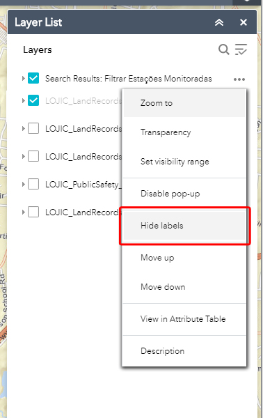
Do you see a hide labels option in the eSearch results layer menu (like indicated in the attached image)?
- Mark as New
- Bookmark
- Subscribe
- Mute
- Subscribe to RSS Feed
- Permalink
Robert,
I can see that option, yes. But I managed to find the problem. It is even a tip if someone goes through the same situation. The layer was configured with the labels since the assembly in mxd. And inside portal too. The solution I found was to ask the geoprocessing analyst, remove the labels from the layer in mxd and republish the service. There inside the portal for arcgis, I removed the old layer, added the new one without the labels in mxd, and configured the label through the portal. Now the label is no longer duplicated.
Thank you for your help and attention.
Thank you!
Gilberto.