- Home
- :
- All Communities
- :
- User Groups
- :
- Web AppBuilder Custom Widgets
- :
- Documents
- :
- Enhanced Search Widget Version 2.23.1 - 11/22/22
- Subscribe to RSS Feed
- Mark as New
- Mark as Read
- Bookmark
- Subscribe
- Printer Friendly Page
Enhanced Search Widget Version 2.23.1 - 11/22/22
Enhanced Search Widget Version 2.23.1 - 11/22/22
Web AppBuilder for ArcGIS | Help - Enhanced Search widget
List of the latest enhancements and changes:
- Fixed issue with Spatial Relationship settings
Older enhancements or changes
Check the "Older enhancements or changes.txt" in the download for a complete list.
Older Versions
Brain,
Does the browsers web console give any error?
Hi Robert,
I am working with someone who wants to use the "Add Shapefile" widget with the eSearch widget. Basically, they would like the ability to add a shapefile to the app at runtime and then use it as the selection geometry. Is this possible?
Thanks!
Scott
Figured it out... had to clear the cache from the older version... ugh.
Scott,
No this is not possible without a significant LOE and that is not in the cards right now.
Thanks, Robert.
So it is then... IMHO, there are quite a few things to improve on that default Print Service, especially when it comes to the legend... As a start I voted up here: https://community.esri.com/ideas/8313 .
Agreed.
Hi Robert,
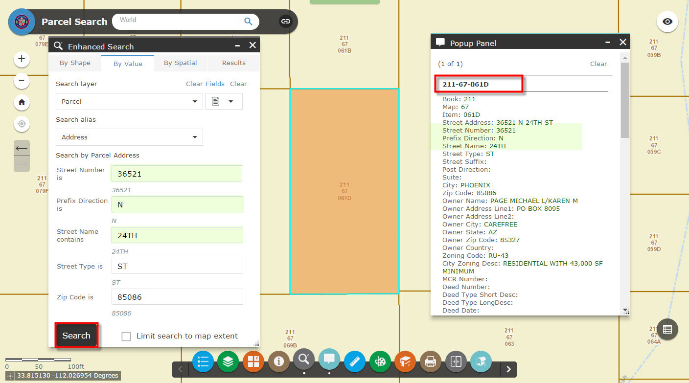
Thanks again for developing this awesome widget. I am just curious if there is away with this widget to do a spatial search off an attribute search. For example if i search for an address can i return its parcel info from the parcel layer.
I was thinking i may have to either:
1. Add the parcel information to the address points
2. Set up a relate - I think i read somewhere popups can use relates now.
Thanks,
Matt
Matthew,
This widget is developed to do a spatial search of a value/attribute search that has first been run. So If I am understanding your question then yes. If you have an address point layer that you search by address and then switch to the by spatial tab and choose the parcels layer and then the intersects button.
All,
Well it has happened again. WAB 2.1 has some breaking changes that are preventing the eSearch from displaying results in the Attribute Table widget the way I have done it in the past. So DO NOT try and use eSearch 2.0.1.x in WAB 2.1, wait for me to fix this issue and release 2.1 version of eSearch.
Hi Robert,
I have an "IN" SQL statement set up, and I wanted to change the input box to a text area. What changes in the code do I need to make to have the text wrapped by the container?

Thank you for your help!
Lesi
Hi, Robert,
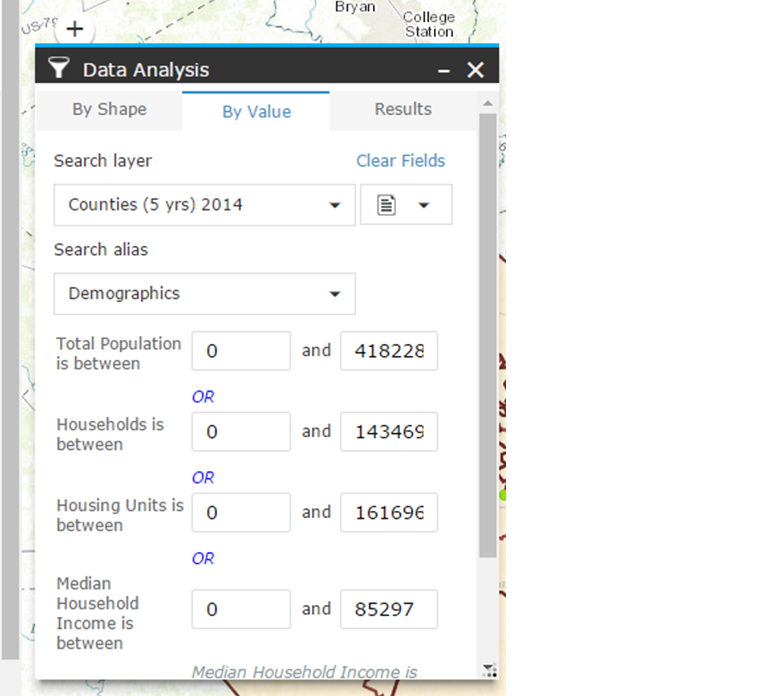
I use ‘between’ expression to set up a query, like 'Total population is between min and max'. My current max value is 8 numbers, and the input window is too narrow (See the picture). Is there any method to adjust the width of input window so that the whole max value can display? Or is that way to adjust the eSearch default window size? BTW, the theme is LaunchPad. Thanks a lot!
Lesi,
Are you using a dijit/form/Textarea or just a standard html Textarea?
Lei,
All widget can have their width set in the main config.json Example:
{
"position": {
"left": 55,
"top": 45,
"relativeTo": "map",
"width": 720
},
"placeholderIndex": 1,
"id": "_5",
"name": "ElevationProfile",
"label": "Elevation Profile",
"version": "2.0.1",
"IsController": false,
"uri": "widgets/ElevationProfile/Widget",
"config": "configs/ElevationProfile/config_Elevation Profile.json",
"icon": "widgets/ElevationProfile/images/icon.png?wab_dv=2.1",
"openAtStart": true
},
Hi Robert,
You are faster than the wind!!
Thanks a million for updating all your Custom Widgets to WAB Version 2.1 so quickly.
I made 8 test Web Apps to play around with your latest Custom Widgets as of 7/22/2016:
Enhanced Search Widget 2.1, Version 58 7/22/2016
https://community.esri.com/docs/DOC-1731
Enhanced Basemap Gallery Widget 2.1, Version 12 7/20/2016
https://community.esri.com/docs/DOC-2888
Google Street View Widget 2.1, Version 12 7/20/2016
https://community.esri.com/docs/DOC-2991
Identify Widget 2.1, Version 24 7/20/2016
https://community.esri.com/docs/DOC-3250
Elevation Profile Widget 2.1, Version 10 7/20/2016
https://community.esri.com/docs/DOC-3342
Map Progress Indicator Widget 2.1, Version 7 7/20/2016
https://community.esri.com/docs/DOC-6416
Enhanced Bookmark Widget 2.1, Version 5 7/20/2016
https://community.esri.com/docs/DOC-6889
Enhanced Locate Widget 2.1, Version 10 7/20/2016
https://community.esri.com/docs/DOC-7046
Popup Panel Widget 2.1, Version 9 7/20/2016
https://community.esri.com/docs/DOC-7355
Other Widgets:
Add Service Widget 1.2, Version 8 11/17/2015
https://community.esri.com/docs/DOC-6263
Add Shapefile Widget, Version 2 9/18/2015
https://community.esri.com/docs/DOC-6907
Zoom Previous Next Widget 1.1.1, Version 3 5/13/2015
https://community.esri.com/docs/DOC-6111
I made a test app for each of the 8 Themes in WAB 1.2
Foldable Theme:
http://www.tapasdas.com/Maps/Phones/app211/
Launchpad Theme:
http://www.tapasdas.com/Maps/Phones/app212/
Dart Theme:
http://www.tapasdas.com/Maps/Phones/app213/
Tab Theme:
http://www.tapasdas.com/Maps/Phones/app214/
Box Theme:
http://www.tapasdas.com/Maps/Phones/app215/
Jewelry Box Theme:
http://www.tapasdas.com/Maps/Phones/app216/
Billboard Theme:
http://www.tapasdas.com/Maps/Phones/app217/
Plateau Theme:
http://www.tapasdas.com/Maps/Phones/app218/
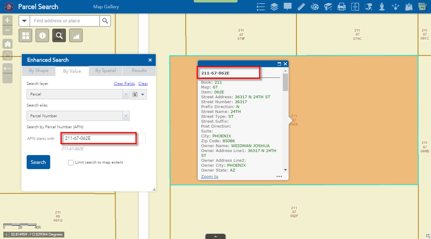
I was pleasantly surprised to find all the new features you have added to the Enhanced Search Widget.
Let's begin with the most popular and useful Foldable Theme.
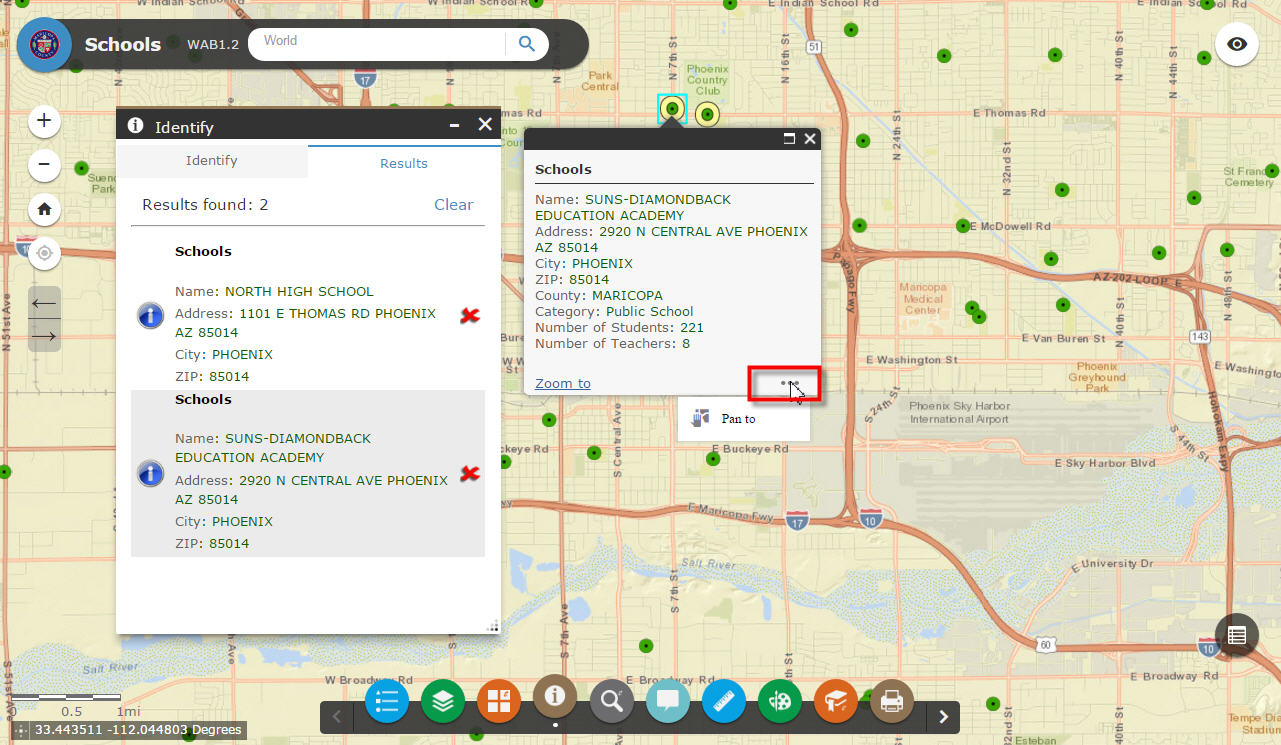
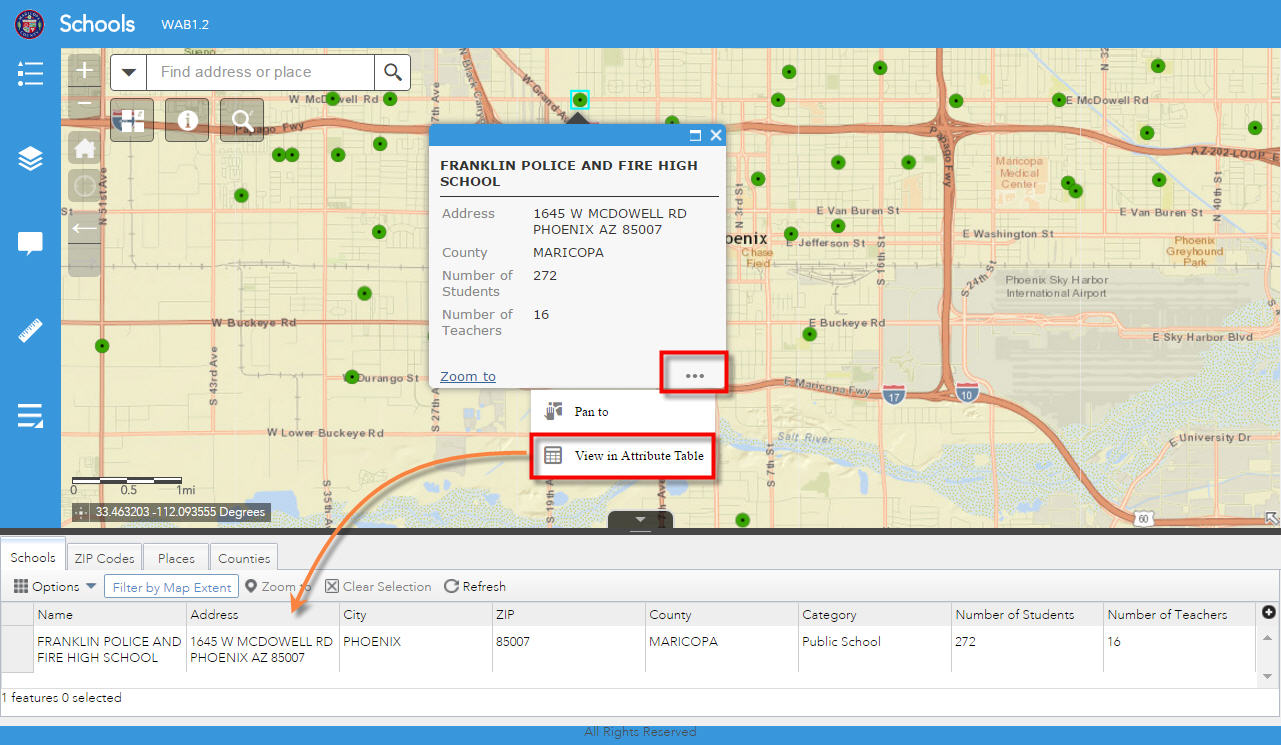
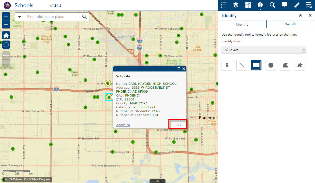
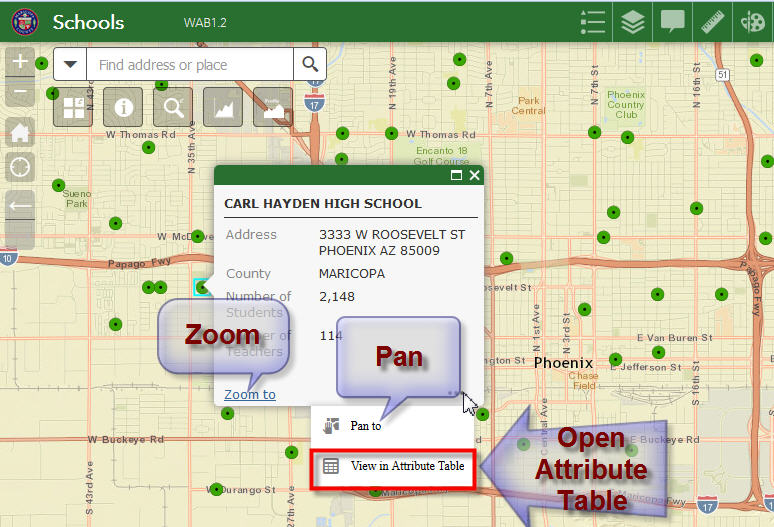
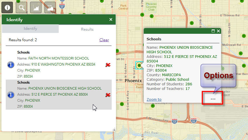
Moxie's team has added a new Options Button on the ESRI Popups.
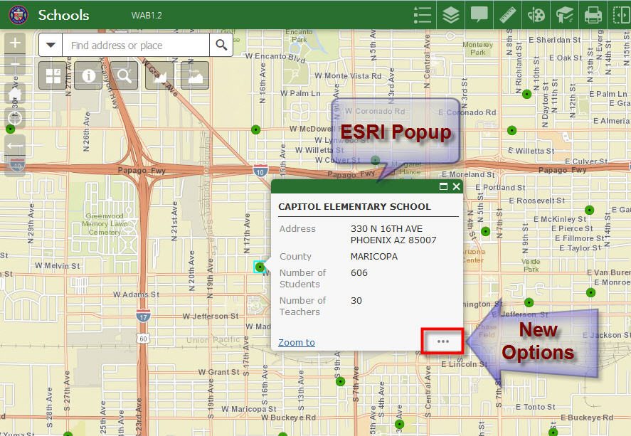
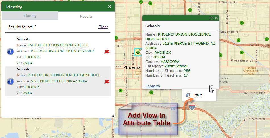
The user can click the Pan to option to move the graphic to the center of the map.
The user also has an option to open the Attribute Table and view the Attributes.
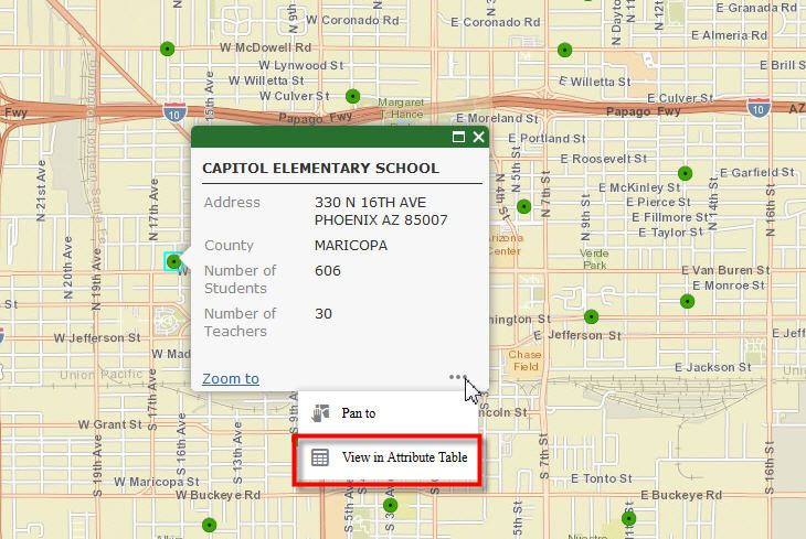
This is the quickest and most elegant way to display the attributes of a feature the user has selected.

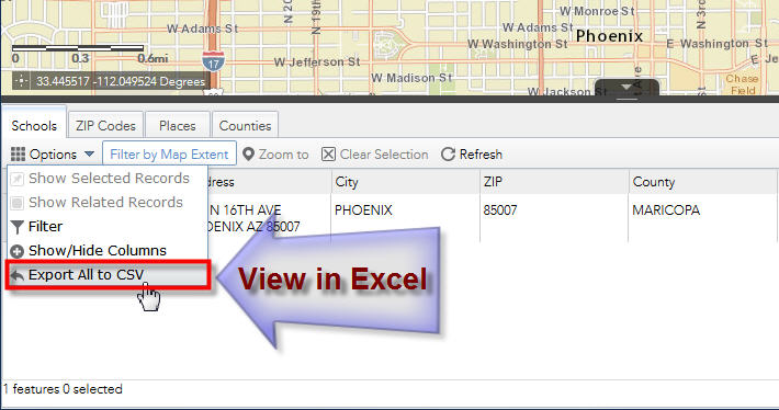
There is a handy shortcut to view the data in Excel.
I see that you have taken the Options Button to a whole new level in your Enhanced Search Widget version 2.1!!
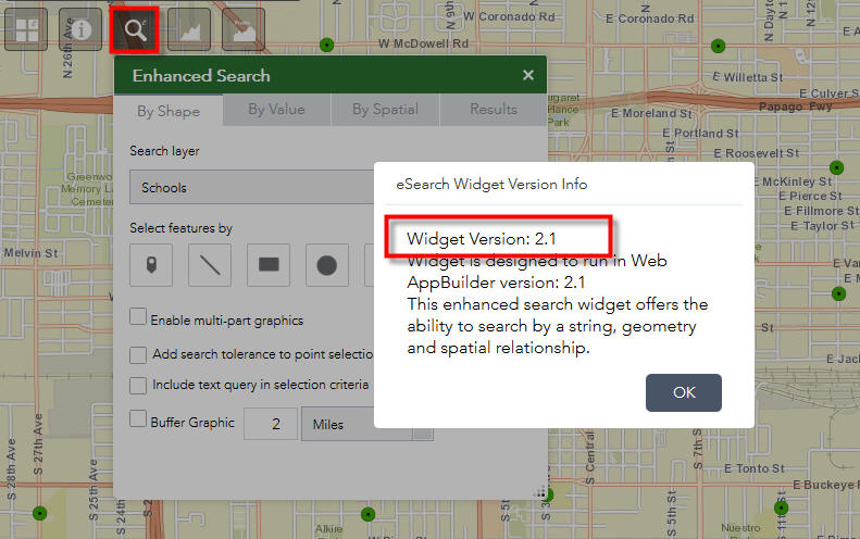
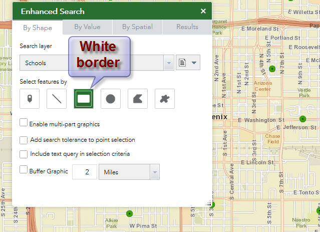
I like how a white border appears on the active tool.
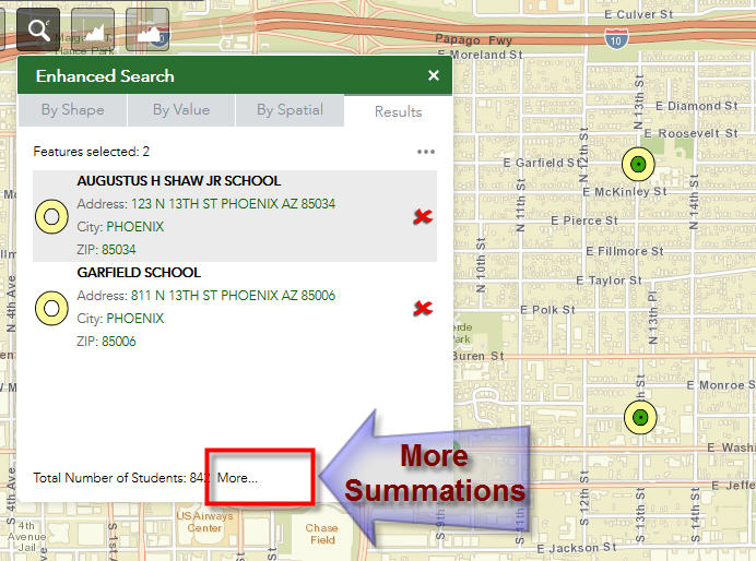
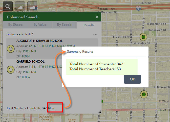
The More... button stills gives me additional summations
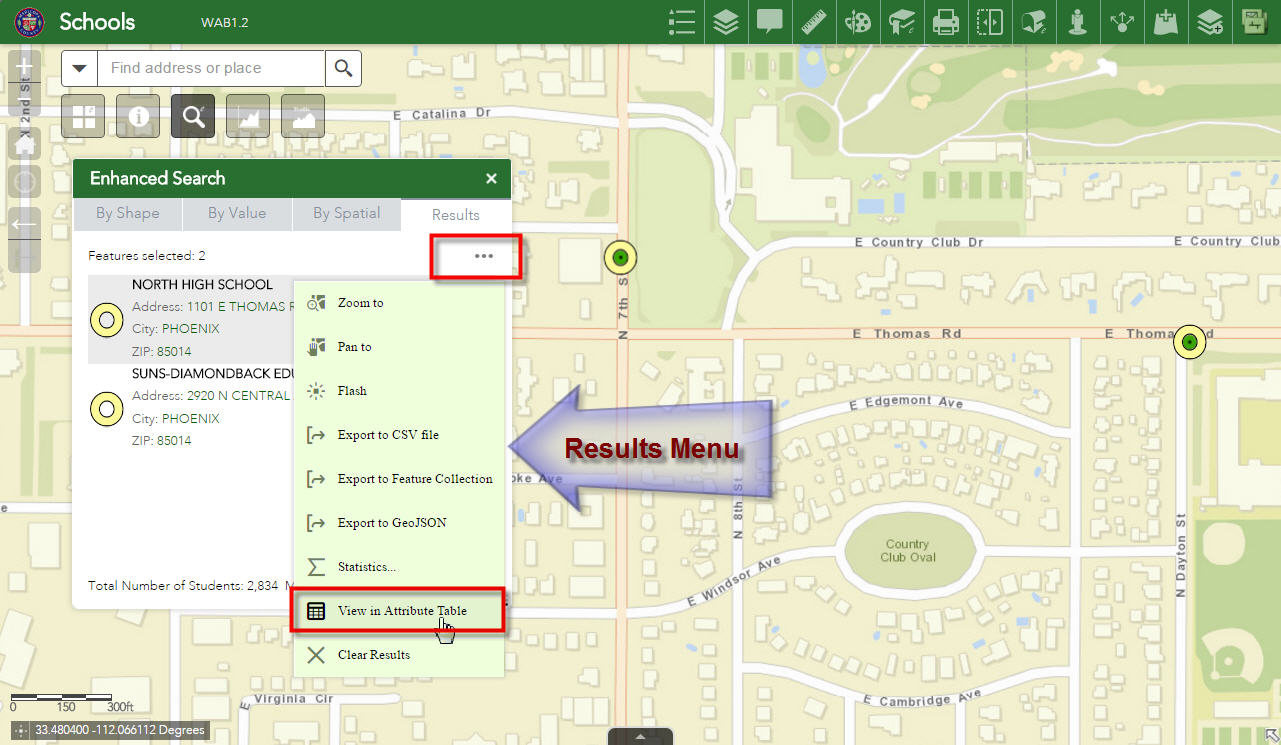
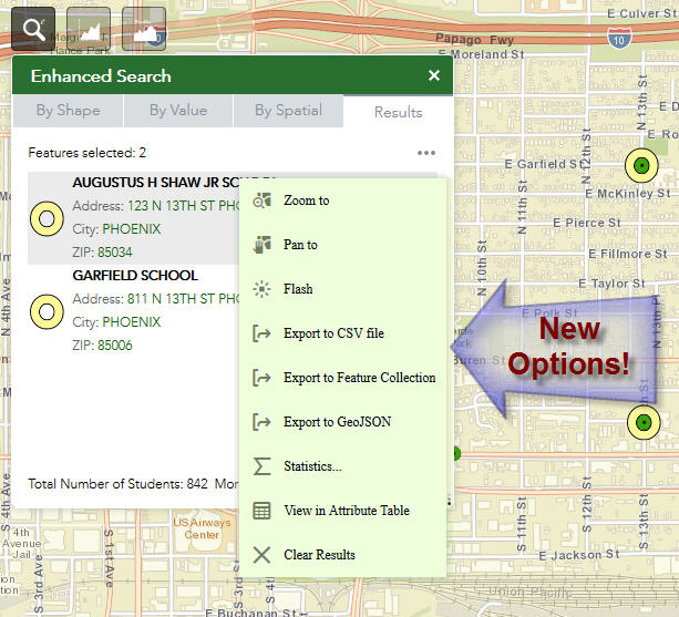
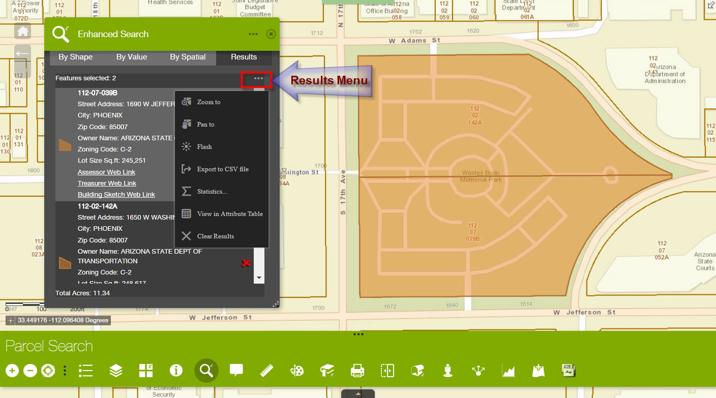
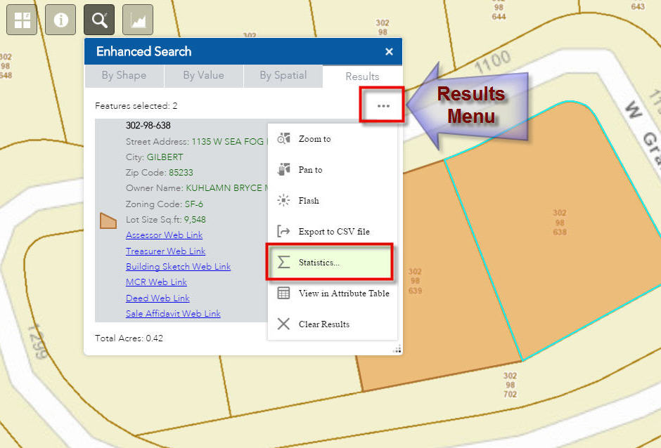
However, you have now implemented a brand new Results Menu.
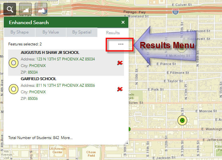
You have implemented all the options the user may ever want in a single menu that is always present in the Results Pane.
You deserve another MVP Award just for this feature alone!!
This is beyond my expectations.
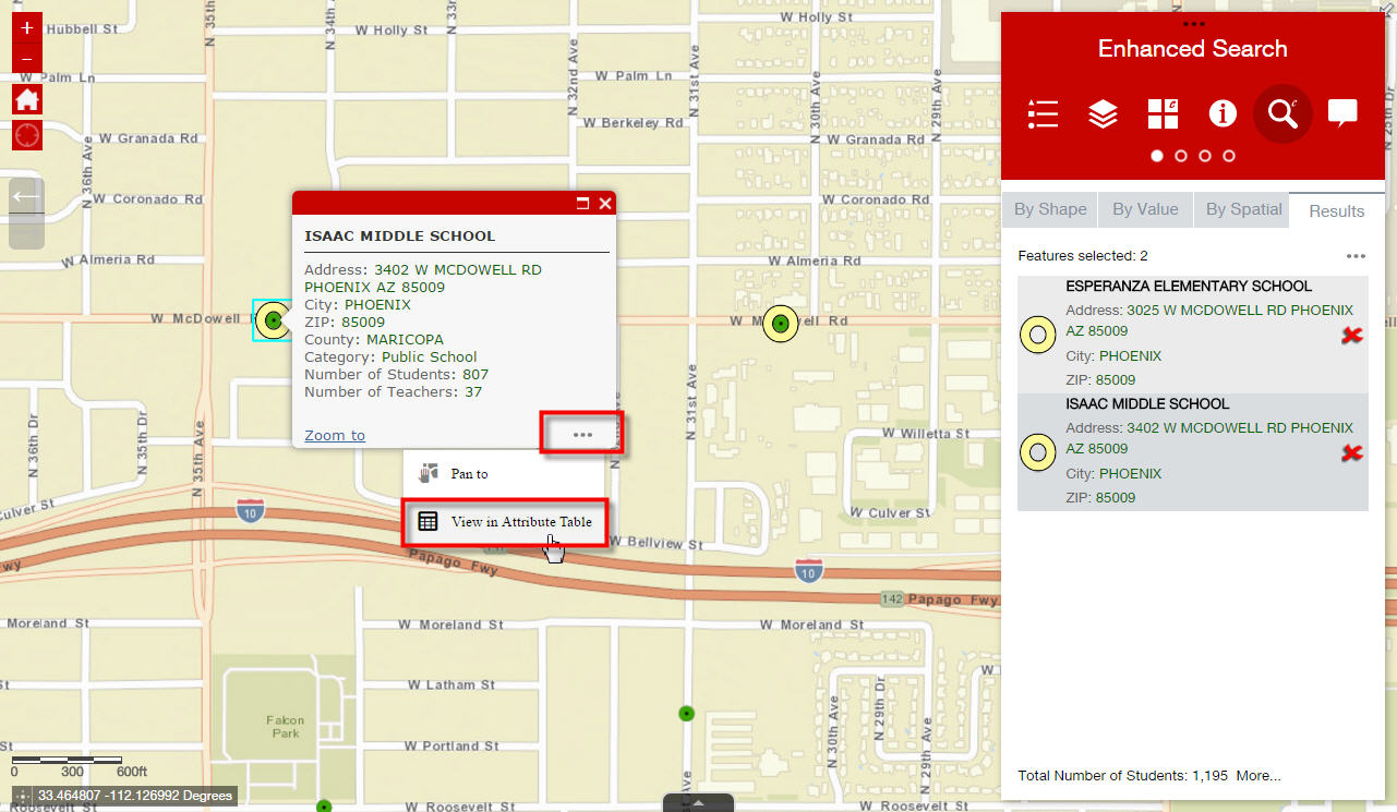
In addition to the Zoom and Pan functions, you have added a very handy Flash feature to differentiate the selected records from a crowded screen.
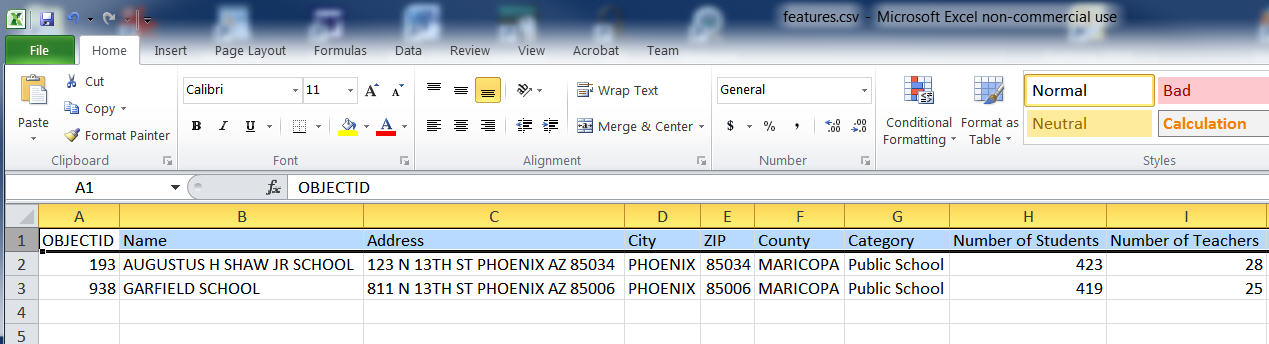
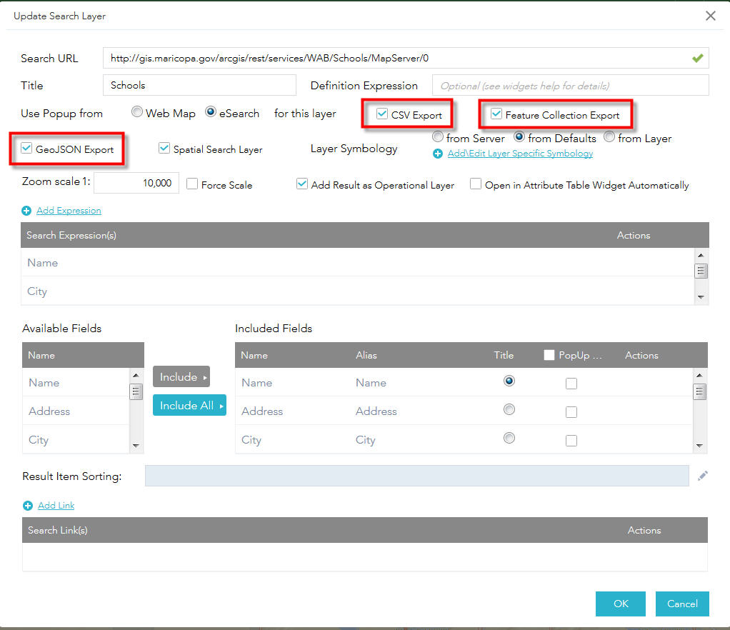
The Export to CSV will be the most used tool by our users.
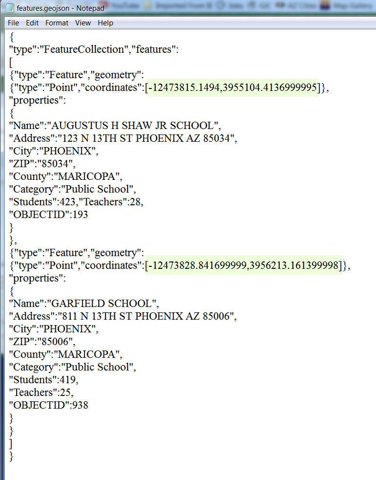
The export to GeoJSON will also be useful. This exports the geometry in addition to the attributes.
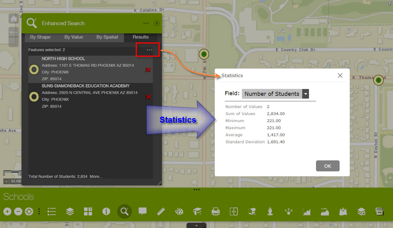
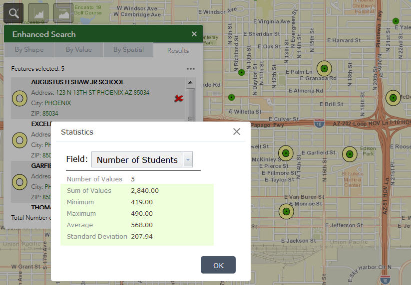
You have gone to town with the Statistics option that includes every possible metric.
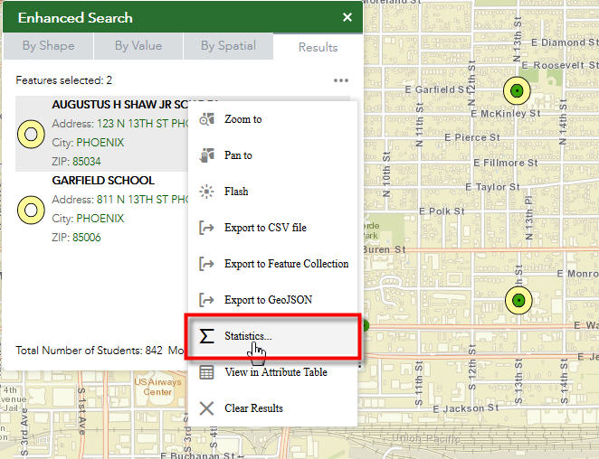
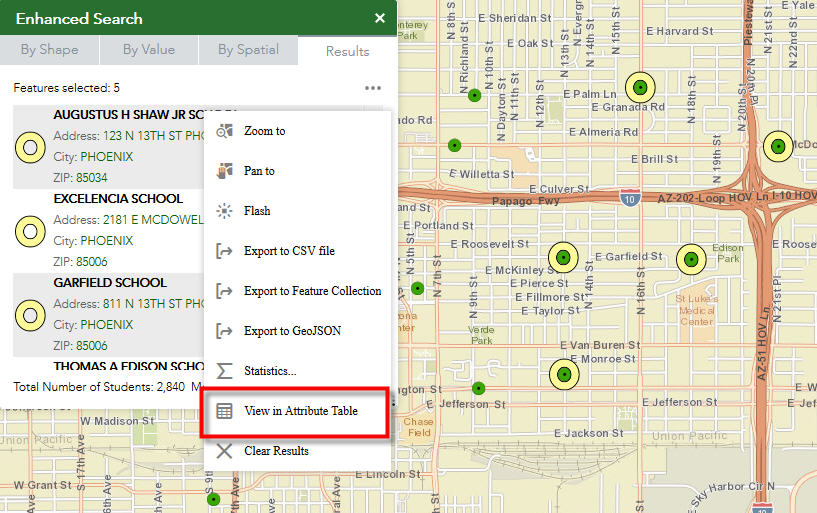
You have retained the View in Attribute Table option that now comes with every ESRI Popup.
I like how Moxie's teams has enhanced the Attribute Table Widget.
You can select and highlight individual records by clicking on the first column.
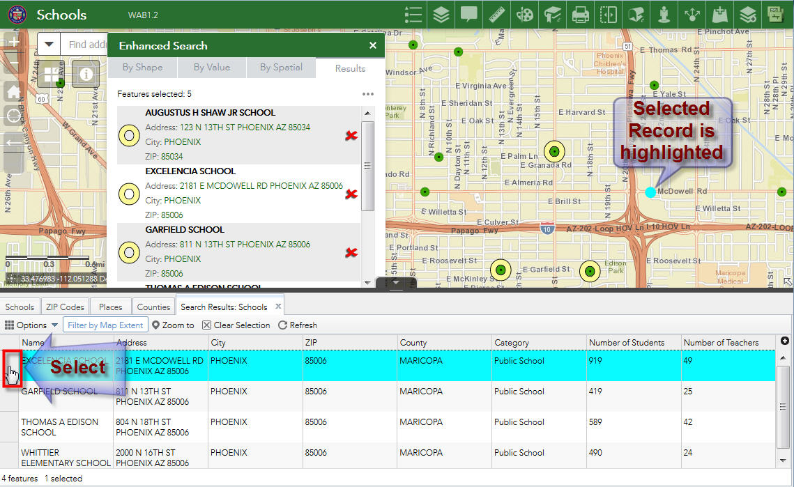
You can now Control Click and Shift Click for making multiple selections.
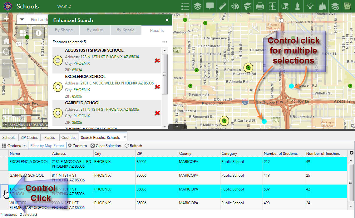
These are wonderful enhancements.
I like how you can configure the options you want to display in the Results Menu.
Robert, you have outdone yourself once again with this new version of the Enhanced Search Widget.
This is a programming masterpiece.
Tapas,
I am glad you like it. I can only take credit for my programming though. The whole action menu and most of the actions on that menu are all esri/Moxie's team (Flash, Statistics, PAN, etc). I knew when I read about FeatureActions in the 2.1 release that I had to add them to my widget. I had some initial trouble with the fact that the eSearch allowed for you to use a GraphicsLayer or a FeatureLayer as the results layer, because GLs did not support even simple actions like pan for some reason. But I found workarounds for most. I really like how the results menu cleans up the results page, which before could have had 4 different links on it (clear, clear buffer, export search url, export csv).
Hi Robert,
Great work on the update. I cant seem to export to CSV when a single selection has been made, exporting functions only seems to become active when multiple features are selected. Am I doing something wrong in my esearch setup.
cheers
Hi Robert,
Yes, the Results Page does look a lot cleaner by including all the options in the Results Menu. Moxie did a terrific job with the new FeatureActions in 2.1, and then you polished it up with your wizardry.
This has matured well beyond the original Flex implementation.
The ESRI Popups now include shortcuts to Zoom, Pan, and View in Attribute Table.
This is now a standard feature with Web AppBuilder 2.1
http://www.tapasdas.com/Maps/Phones/app211
When I use your Identify Widget version 2.1, make a selection, and open the Options Menu, I see shortcuts to Zoom and Pan,
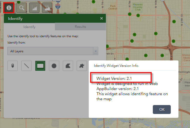
Will it be too much of work to add the View in Attribute Table button?
I know our users will ask for it in the Identify Widget the moment they see it working on the Enhanced Search Widget.
Hi Robert,
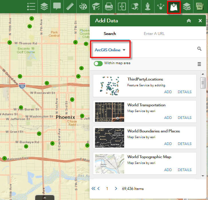
Moxie and Jianxia Song did a marvelous job with the new Add Data Widget.
This has the potential to replace the Add Service and Add Shapefile widget when fully implemented.
The above two custom widgets allow us to add Map Services and Zipped Shapefiles on the fly to a Web App. However, we also needed the ability to add CSV files.
There was a Load Excel and CSV files widget in the Flex Version that did that trick.
http://www.tapasdas.com/Maps/Desktops/web12/
Jianxia's Add Data Widget in WAB 1.2 is working like a charm!
http://www.tapasdas.com/Maps/Phones/app211
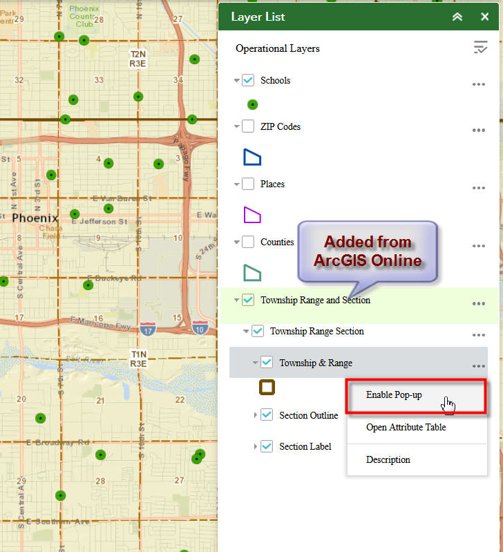
The interface makes it a child's play to add data from ArcGIS Online.
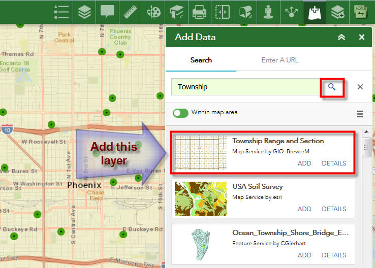
Here I am searching for the Township Layer
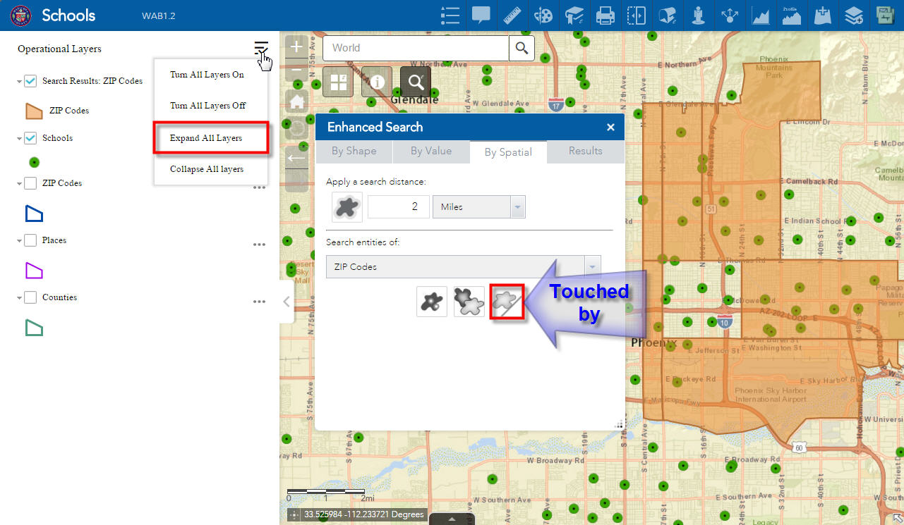
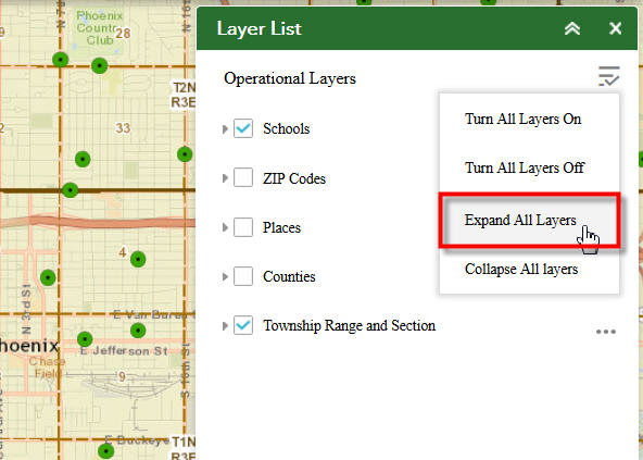
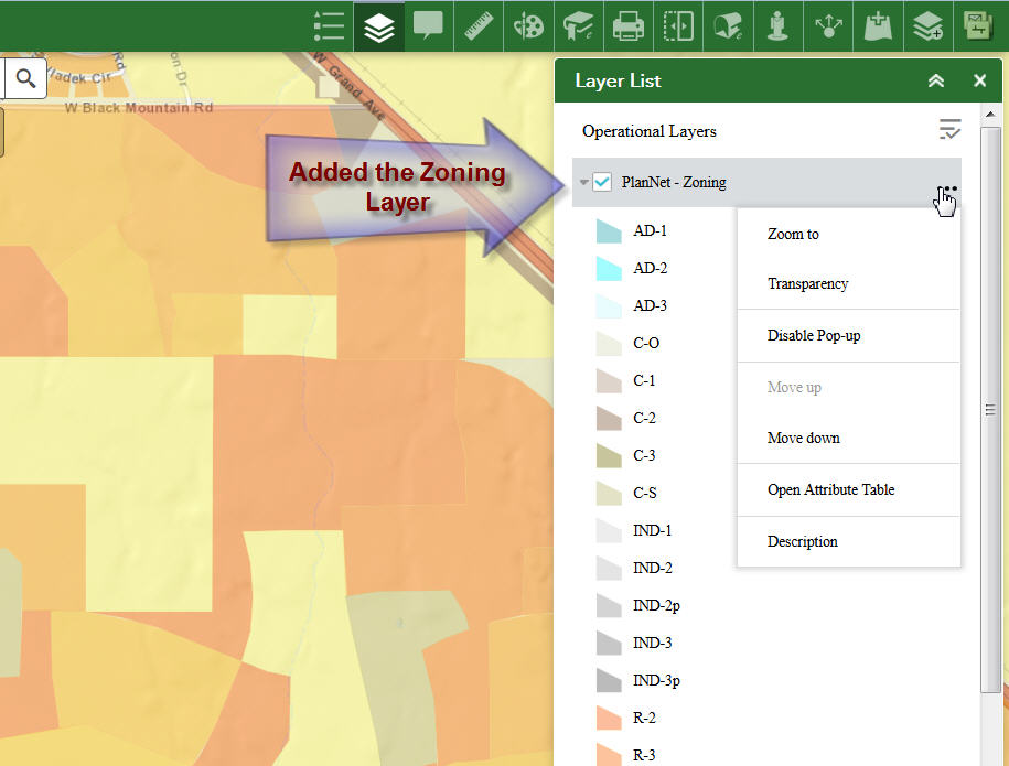
I like the option menu on the Layer List widget
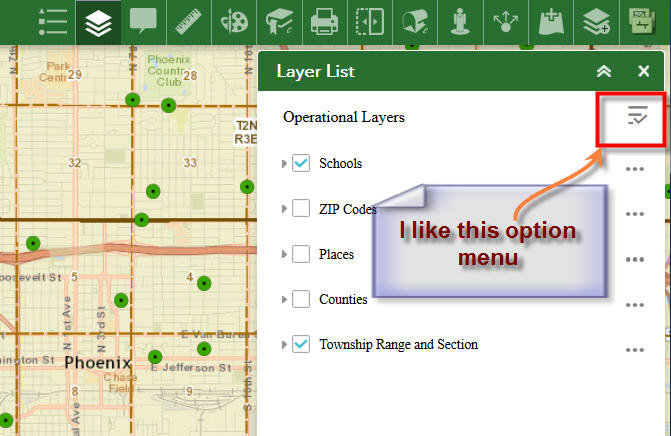
This makes it very easy to expand all the layers and view the legend.
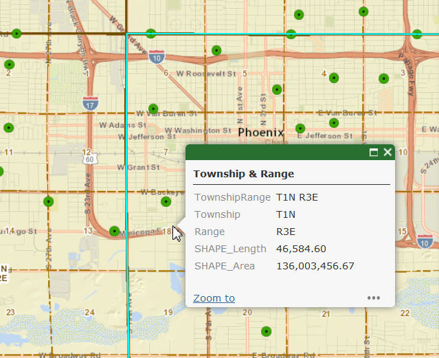
I can enable the Popups and view the attributes of the Township Layer I added from ArcGIS Online.
I can add any Dynamic Map Service if I happen to know the URL:
http://gis.maricopa.gov/arcgis/rest/services/PlanNet/Zoning/MapServer/3
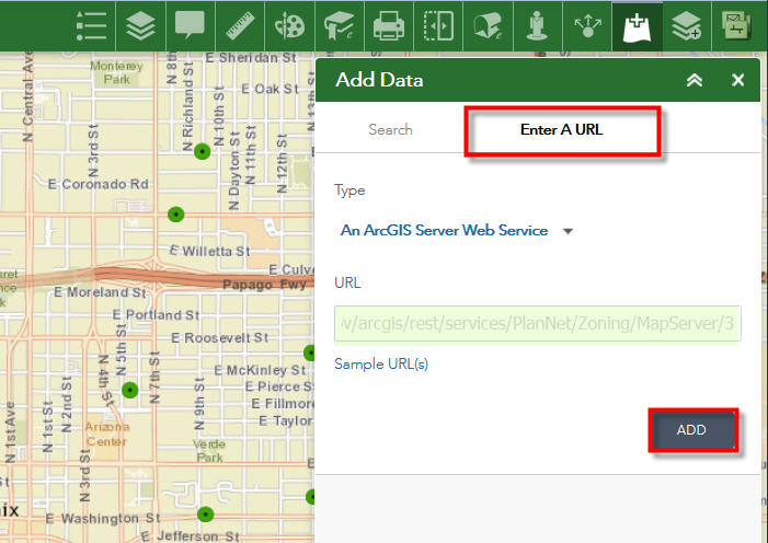
The Zoning Layer is now visible on the map
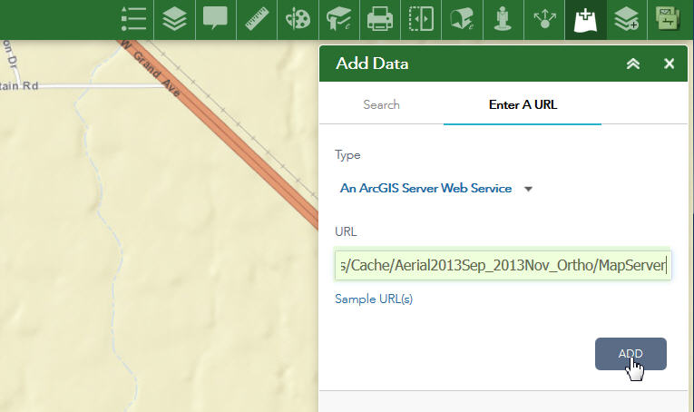
I can add any Tiled Map Service:
http://gis.maricopa.gov/arcgis/rest/services/Cache/Aerial2013Sep_2013Nov_Ortho/MapServer

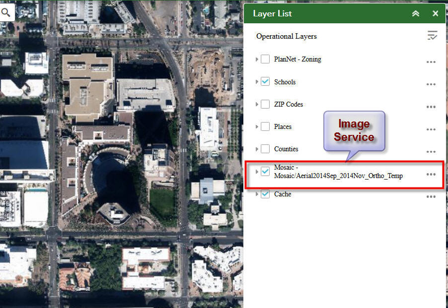
I can add any Image Service:
http://gis.maricopa.gov/arcgis/rest/services/Mosaic/Aerial2014Sep_2014Nov_Ortho_Temp/ImageServer
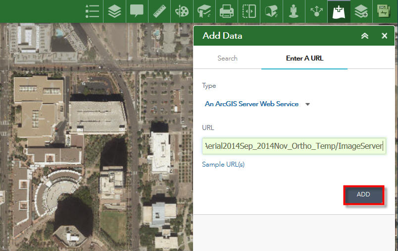
The Image Service masks out the Tiled Map Service.
I also have the option to move layers up or down if necessary.
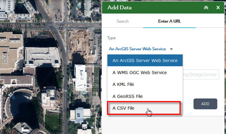
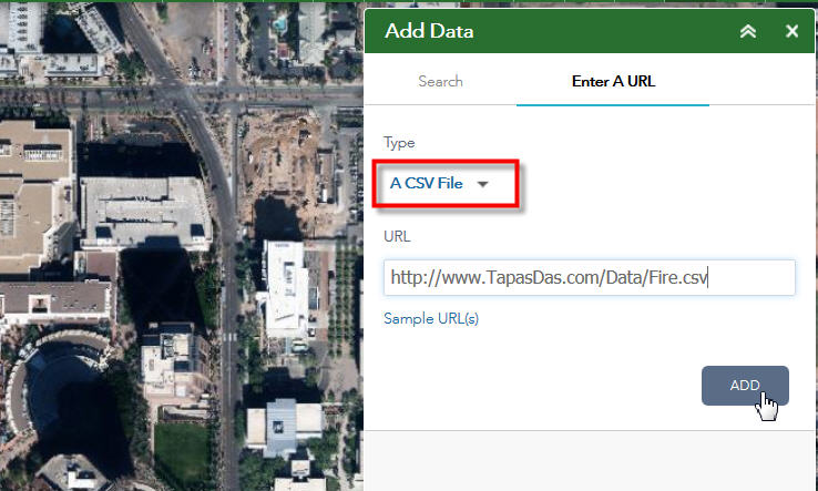
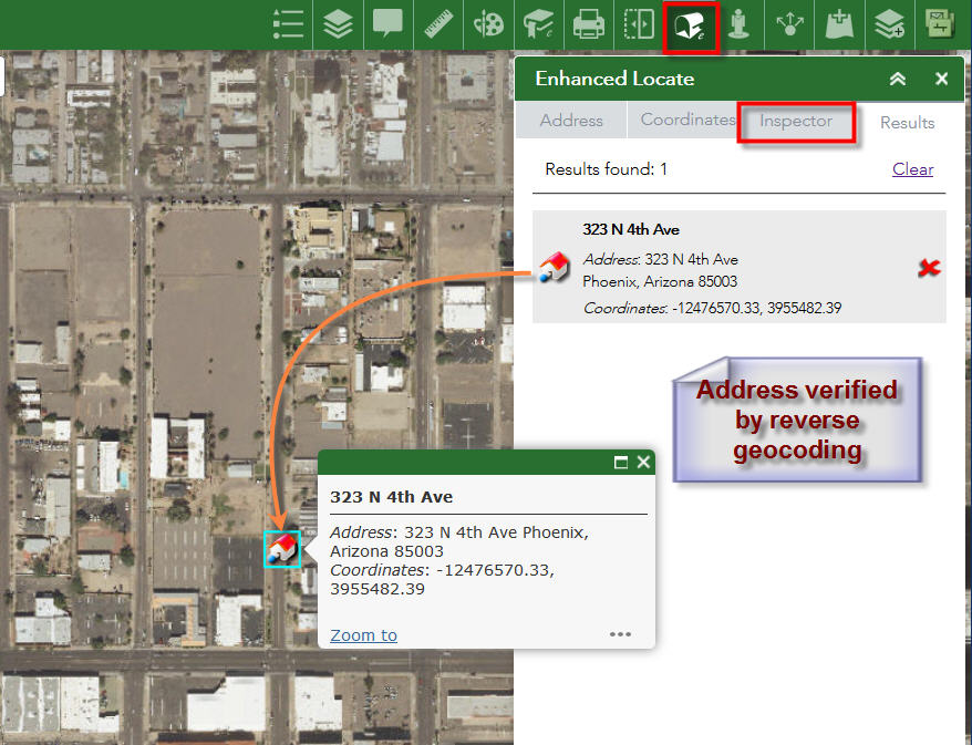
Thanks to Jianxia, I can even add data from CSV files to my web map:
Here is the CSV data for the Fire Stations:
http://www.TapasDas.com/Data/Fire.csv
The Fire Stations show up on the map as black circles.
The Address contained in the CSV file reads:
323 N 4TH AVE, PHOENIX AZ 85003
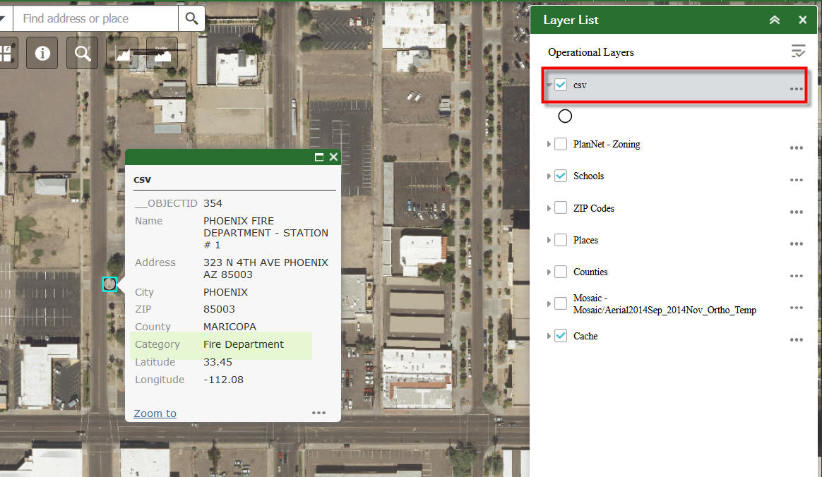
Using your Enhanced Locate Widget, I can reverse geocode this location to verify the address.
The address returned is a 100% match.
I am amazed how much one can do with these simple light-weight web apps.
Web based GIS is the future.
Hi Robert,
ESRI has added a Share Widget in WAB 2.1 that closely mimics your Custom Share Widget.
http://www.TapasDas.com/Maps/Phones/app211
One can configure this Widget to remove or include all 4 links.
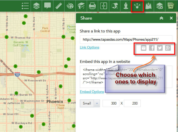
The user can specify which parameters to include in the link.
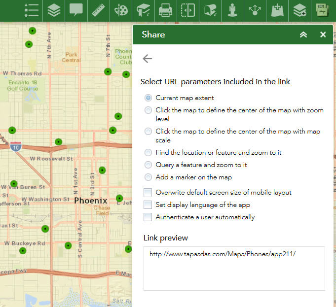
The user can set the size when embedding the app in a website.
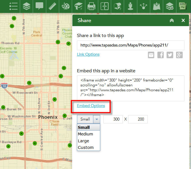
Since we have a naming conflict, perhaps you may want to rename your widget to eShare.
I see that this is the only widget you have not upgraded to version 2.1
Rod,
The CSV export I am using is now the esri default action and it seems that they do not enable it if you don't have more than one result. I will have to look into this.
Tapas,
I am kind of leaning to the fact my widget has been superseded by the new OTB Share widget. There is nothing that mine does that the new OTB one does not do.
I thought it may have been by design. If you can do something that would be great.
cheers
Rod
Rod,
The work around at the moment is to view in attribute table, and use the export to CSV in there.....That works for single selections
Baba
Hi Robert,
I tried to change the data type to dijit/form/Textarea and defined it in Widget.js. But that doesn't work. I don't know JavaScript enough to tell the difference between dijit/form/Textarea and regular html textarea. Which way would you suggest?
Thank you for your help!
Lesi
Lesi,
My recommendation is that you start a new thread so that you can post what you have attempted so far.
Hi, Robert,
I add the following in main config.json:
"position": {
"relativeTo": "map",
"left":200,
"width":720
},
"openAtStart": true
The "openAtStart" works; but width is not changed at all. "left":200 is not working, either. Is that because the theme is LaunchPad so it is not working? Thanks a lot!
Lei,
Launch pad does not allow you to make adjustments to the widgets width or position like other themes.
See these threads for code workarounds:
Layer List auto start location change
how to change the width and height of the custom widget pragmatically in launchpad theme?
Hi Robert - In my folded theme I am noticing that unless the results layer is added as an operational layer, the results menu is not enabled, or otherwise does not respond when clicked.
Thanks,
David
David,
Re-download the widget. If you got it right after I released that day I found that issue and re-released a fixed version.
Hi Robert, yes that did the trick. Um, fyi I notice here again that unless you add as operational, the options for statistics and view in attribute table are not present as a results menu option....
David,
Statistics and View in Attribute Table are not available for graphics layers.
That's right, you posted that above sorry about that . . .
Hi Robert,
Not sure if this is a bug in your latest esearch release, but I seem to be having date display issues when exporting to CSV via esearch. However if I export to CSV the same date field information using the attribute widget the dates display correctly in the csv file. Am I doing something wrong with my esearch setup for dates. Any advice would be useful.
cheers
Rod
Rod,
I started using WAB built in CSV export ability and it does not format dates. I see that the AT widget uses a completely different way of exporting to CSV. I will have to fix this in the next release.
Robert,
Love your eSearch widget - we've been using it since FlexViewer days... We ran into some performance issues recently and I'd humbly like to submit a few enhancement requests/ideas. What would be the best way to send them to you? Cheers, Keith.
Keith,
Just post them right here, or start a new discussion if you need the ability to attach something.
Hi Robert,
I just wanted to say thank you for your awesome Enhanced Search Widget that we are now using on every web application.
As an example, we recently replaced the GIS Viewer within Accela with a simple Web App built around eSearch 2.1.
Accela is a third party application that handles permits. It has something called the External Address/Parcel/Owner (XAPO) integration that allows you to tie into your Parcels Map Service. The user can search for a Parcel by Address, APN, or Owner and bring up the related permits within the Accela interface.
We built a web app in less than 4 hours that mimics that, but also adds a host of new functionality absent in the standard Accela implementation.
Our users love it!
Here is our Parcel Search web app using Enhanced Search Widget 2.1 built around the Foldable Theme:
http://www.tapasdas.com/Maps/Phones/app219/
This is the Launchpad Theme version:
http://www.tapasdas.com/Maps/Phones/app220
This is the Dart Theme version:
http://www.tapasdas.com/Maps/Phones/app221
This is the Jewelry Box Theme Version
http://www.tapasdas.com/Maps/Phones/app222
In addition to eSearch 2.1, I am also using Identify 2.1, Popup Panel 2.1.1, eLocate 2.1, eBasemap 2.1, and others.
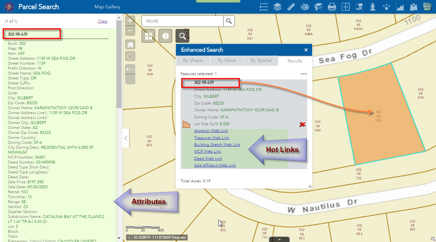
Just like in the Accela GIS Viewer, the user can now select and zoom to a Parcel by entering an Address, APN, or Owner name.
All the hot links to the Assessor’s Office, Treasurer’s Office, and County Recorder’s Office show up.
Your Popup Panel 2.1.1 makes it very convenient to display the long list of attributes.
All of this is functioning perfectly like a well-oiled machine. We could not have asked for a better solution.
However, I ran into one issue, and would like to run this by you for a possible future enhancement.
I am selecting 2 parcels by Shape in the Foldable Theme:
http://www.tapasdas.com/Maps/Phones/app219/
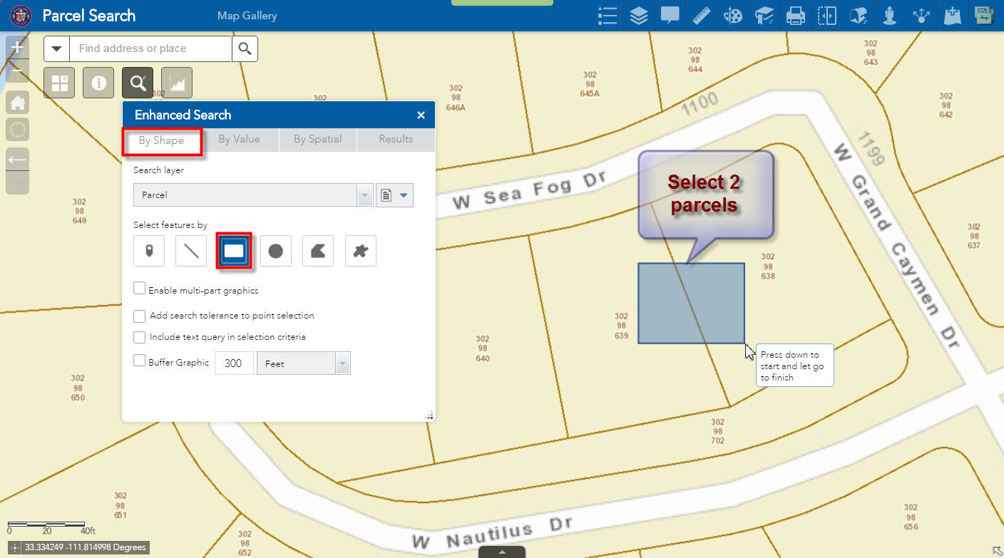
I have a short list of attributes. All the hot links work perfectly.
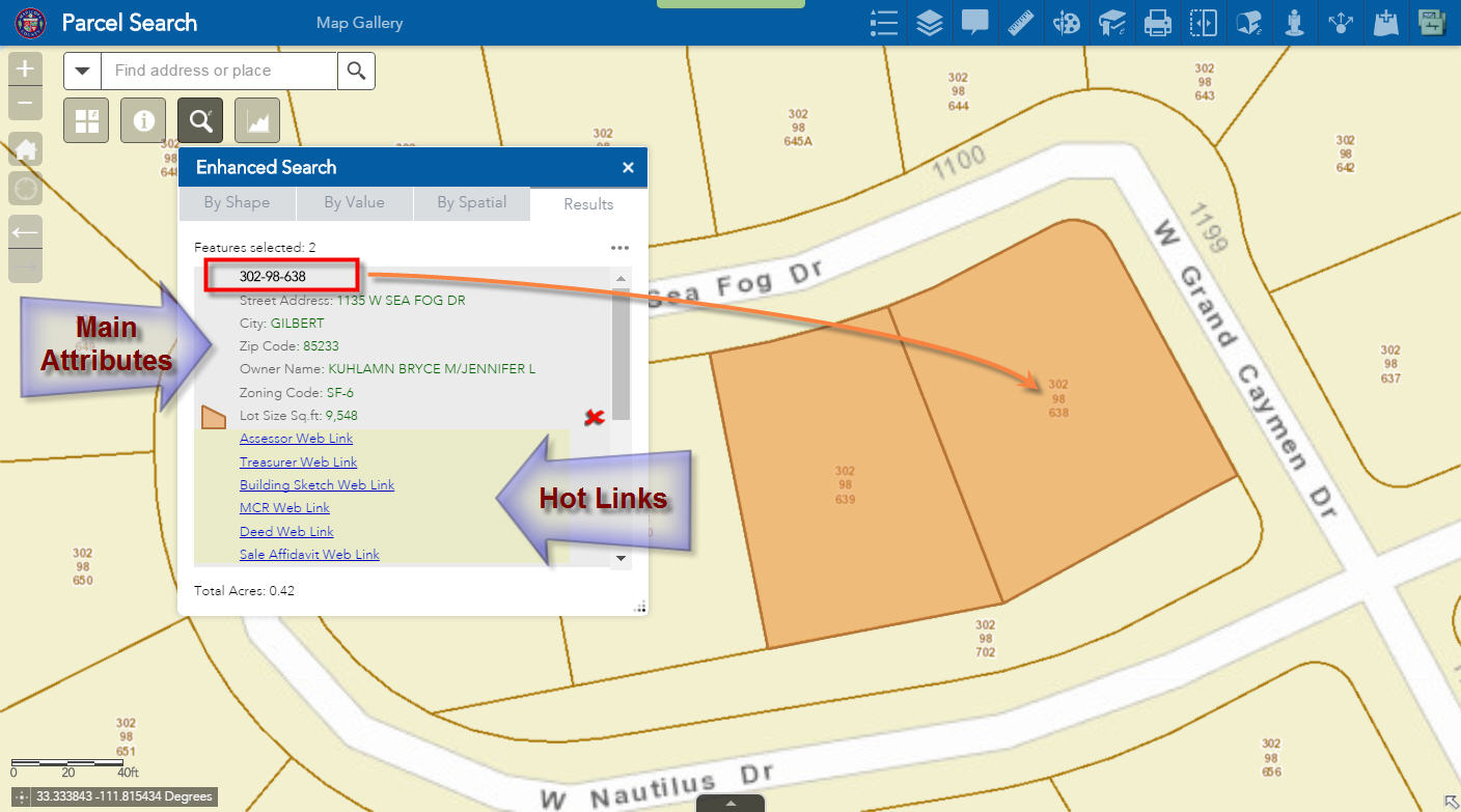
I can click on a selected record to view the long list of attributes in the Popup window.
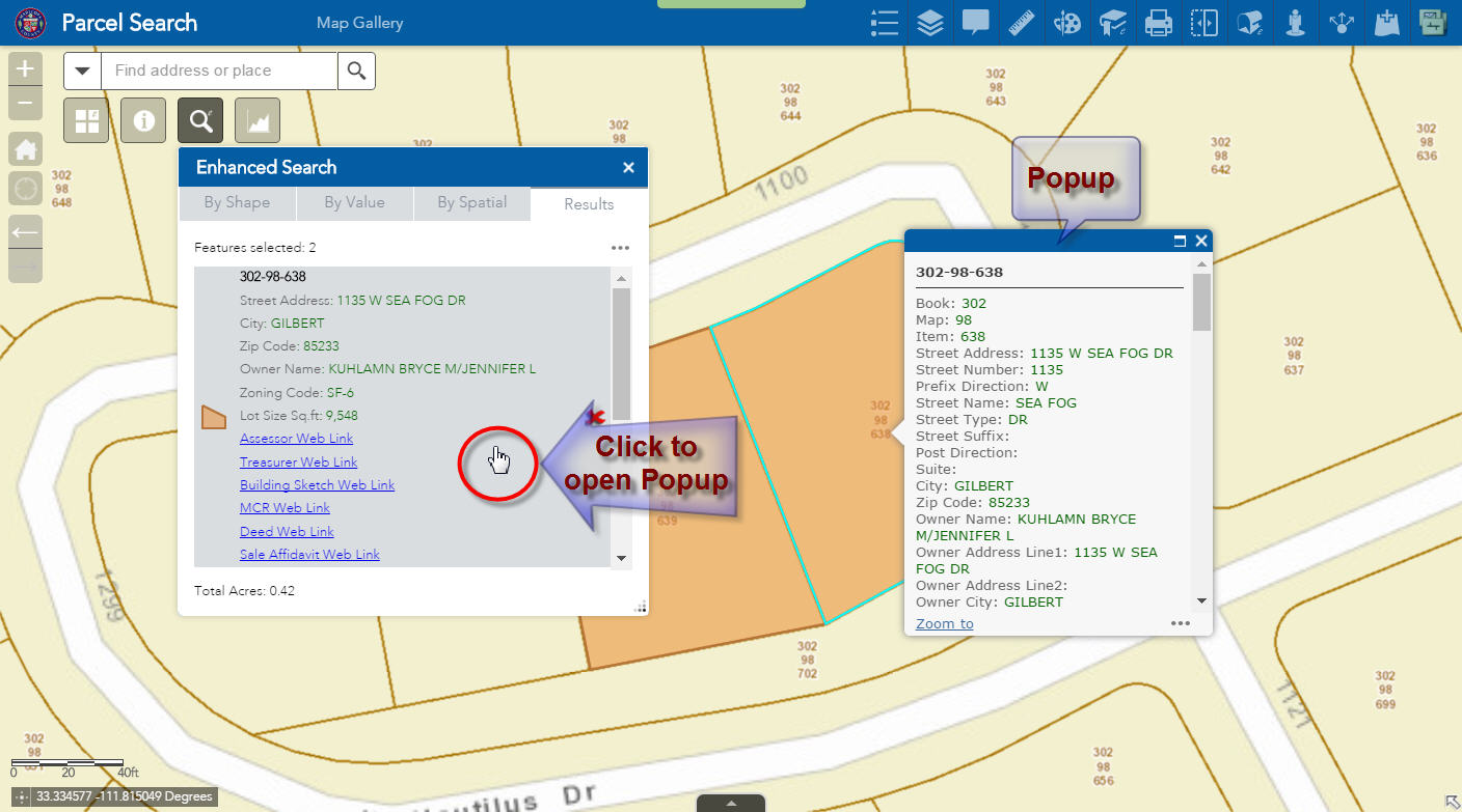
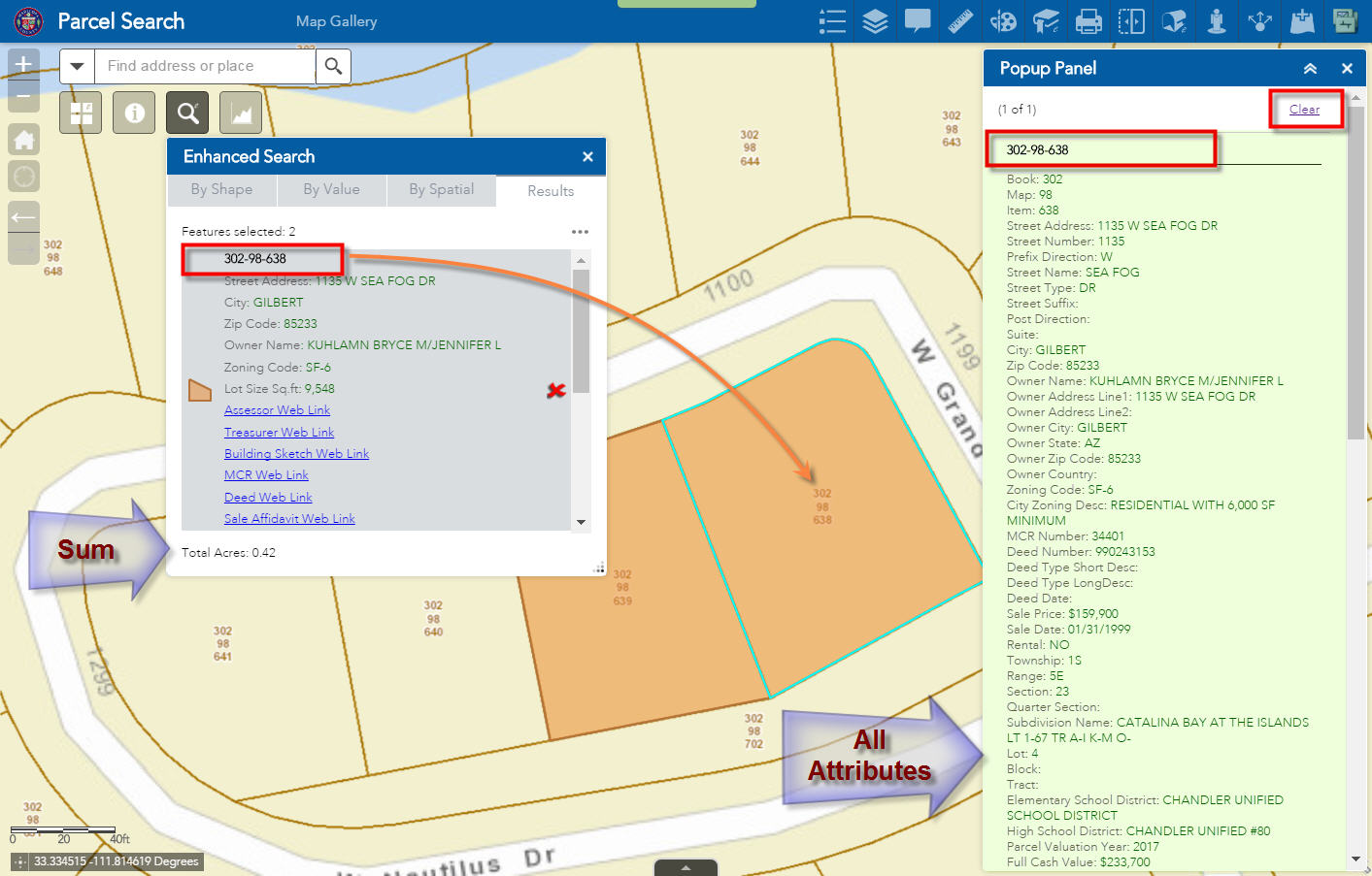
Opening the Popup Panel Widget makes it easier to browse through the long list of attributes.
Pressing Clear closes the Popup Panel.
I see a quick summation of the Total Acres of the selected parcels.
When I open the Results Menu, I get a list of handy shortcuts.
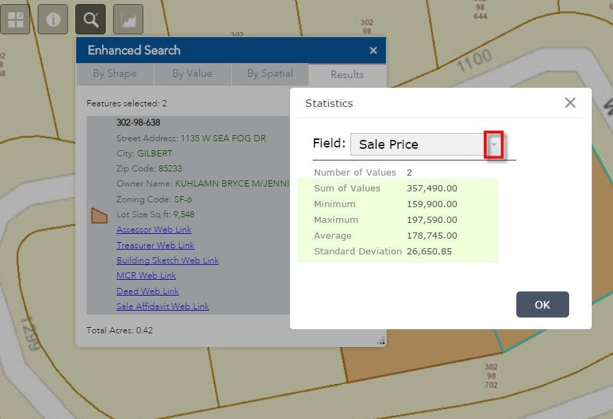
When I click on Statistics, I see an instant breakdown of the Sale Price.
So far, so good.
However, the moment the user clicks on the down arrow, they get to see too many choices!
I would like only these to show up:
Sale Price
Full Cash Value
Assessed Full Cash Value
Land Full Cash Value
Assessed Land Full Cash Value
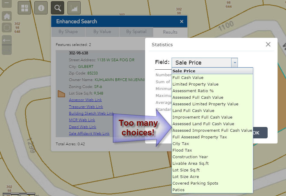
By default every numeric item is being included in the drop down list.
Can I have a way to enter a flag in the config.json file to show statistics for only the numeric items I want to display?
For example:
This enhancement will make it a lot easier for our users and tidy up the interface.
Wow TAPAS DAS,
Envy your detailed work, quite informative too. 
Hi Baba,
Thanks for the kind words!
Robert’s magical widgets for the Web AppBuilder completely transformed the way I build apps. I can now devote my time in creating custom apps on demand without having to write a single line of code or spend time in the Q&A process. It just works.
This has been a lifesaver for us.
Tapas,
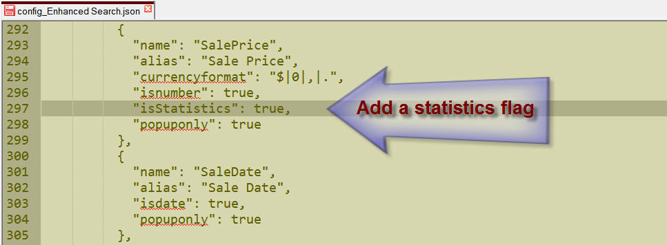
I like that idea. The only problem is that the statistics is an esri action and not part of eSearch. I will see what I can do to control the fields that go to it though.
Robert,
Ok, I understand that this is coming from ESRI.
But, if you could make your programming magic work to filter the fields that are shown in the listing of Statistics, that would be awesome.
Hi - is it possible to add a select by an existing layer selected polygon shape. so that it will select points based on another polygon layer and/or a selected set of polygons from an existing polygon layer/.
Yoav,
Have you looked a the spatial search option on the eSearch?
Here is the help link for that feature: Web AppBuilder for ArcGIS | Help - Enhanced Search widget | Spatial Search
I have looked. However I don't see where I can use an existing polygon (or a selected polygon from an existing layer) to base my selection. I can see that i can draw a poly manually but not use an existing one.
Hi Yoav - if you set your poly and point layers of interest as spatial selection layers in the eSearch you will be able to select a poly by attribute or by graphic and then use that selection to select your other layers.
David
Yoav,
The "By Spatial" works after a graphics or attribute selection is made in the widget. So you use a graphical selection or a attribute selection on one layer and then switch to the "By Spatial" tab and choose the other layer you want to select from and then click on the spatial relationship button you want to use. I don't see how this is not what you are asking for.
Robert, I had a longer post with details but I will first ask -- Did eSearch 1.3.02 support relates? It appears you added it at some point (eSearch widget and related tables ) i.e. would related info show up in the attributes and would I be able to make a Link out of a related attrib? I'm on WAB 1.2 and Server 10.2. Do you have a repo or archive of old widget versions? I didn't see them in your GitHub.
Kevin,
No unfortunately you are misinterperting that thread. Relates are not supported yet in the eSearch. I have begun work on it but there is a LOT of work to get to that point I first have to support flat (non spatial) tables and then some other things before I can add related table support. Relates will be added to the latest release only when I do get them added.
Robert Scheitlin, GISP - thank you for your reply! Are temporary (mxd) joins supported? (I'm guessing no, since those also were not returning results plus they don't work with AGOL identify anyway...but just wanted to check)
Kevin,
Yes joins will work as long as you can see the joined data in you fields listing on the REST endpoint of your map service then the eSearch can use that joined field.