- Home
- :
- All Communities
- :
- User Groups
- :
- Web AppBuilder Custom Widgets
- :
- Documents
- :
- Enhanced Locate Widget Version 2.16 - 08/21/2020
- Subscribe to RSS Feed
- Mark as New
- Mark as Read
- Bookmark
- Subscribe
- Printer Friendly Page
Enhanced Locate Widget Version 2.16 - 08/21/2020
Enhanced Locate Widget Version 2.16 - 08/21/2020
Here is another widget for the Web App Builder.
Web AppBuilder for ArcGIS | Help - eLocate Widget
Features:
- Locate and address (like the search widget, but gives you the ability to limit the address search to the maps current extent).
- Locate coordinates using user defined spatial reference coordinates (i.e. DMS, State Plane, Etc).
- Reverse Geocode capability called Address Inspection. Address Inspection is clicking on the map and getting the address of the map click point.
List of the latest enhancements and changes:
- Fixed issue with result tab being disabled and widget attempting to select the results tab.
- Fixed feature popups not working when the address inspector is activated and widget is closed.
- Add ability to specify a transform WKID.
- Added ability to specify the WKID that coordinates in the popup are displayed in.
Older Versions
Hi Robert,
We use your widget a lot, and it works flawlessly with WAB 2.12. After upgrading to WAB 2.15, the WKID can't be set. Even when I use the values from your example, I only get empty fields. Here is what it looks like:
Any help would be highly appreciated.
This is an issue that has been discussed a couple of time here. See this thread for the workaround.
I can't download the json file from here: https://gis.calhouncounty.org/wab/wkidDetails.json
The URL seems to be broken. Could you upload it somewhere else?
Many thanks in advance.
I just tested the link and it works fine.
I checked it using different PCs and different ISPs, the URL is unavailable. I can't access your Live Preview Site, either. Is it possible that calhouncounty.org uses geoblocking and it is inaccessible outside the US?
True I didn’t consider that. The way that you will have to fix this is to open that file and copy the text into a online JSON linter and find the syntax error in there or just copy that file from your older 2.13 or less version of WAB.
Dear Mr. Robert Scheitlin, GISP,
we are using enhanced locate widget in the field of water resources. Our need would be to display the coordinates of WGS and Hungarian projection (EOV) simultanously in the same map pop-up window.
F.e. When I specify WGS coordinates, I expect that EOV coordinates will be displayed at the same time as well in the pop-up.
I have tried to change the JS code, however it is still not solved. What do you advice? Thank you in advance! ![]()
Balazs
Balazs,
Here is a reply where someone asked a similar question and I answered already:
Dear Robert,
we have tried to change the code accordingly. The code is simple javascript. It is not clear, how could we change it so, that we can see the coordinates transformed into Hungarian projection.
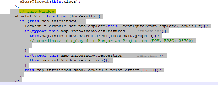
The related section for displaying the coordinates:
Balazs,
Not sure how that code has anything to with my widget... But in the code above you need to project the geometry to your desired wkid. So you need to use the Geometry service project method as shown in the code I referenced earlier.
esriConfig.defaults.geometryService.project(projParams, lang.hitch(this, function(results){https://developers.arcgis.com/javascript/3/jsapi/geometryservice-amd.html#project
Hi Robert,
Thanks for this great widget. I am having an issue with the "Inspect Address" tool - in the title where the address should be, I instead see "eLocate". This only occurs for locators created in ArcGIS Pro using the "POI" role. Is this something that can be fixed within the widget JS file?
That is the default behavior when the locator does not provide a address. This widget is not been designed or tested to work with POI locators from Pro. I could possibly provide to code change guidance if your locator is public for me to access and test against.
@RobertScheitlin__GISP, that would be wonderful. The locator is public and available here: https://public.sagis.org/arcgis/rest/services/Locators_Pro/MAD_POI_FullAddress/GeocodeServer
The "Point of Interest" is mapped to our Full Address field.
Robert,
Is there a new version of this, trying to add to Webapp Builder 2.20. When trying to configure the widget and add a map coordinate unit I get an error. Regardless of what WKID I put in the text input will remove the text and the text box becomes red. So I am unable to add a new coordinate system.
Error Message using developer tools.
Any help would be appreciated.
Thanks,
Jason
This is a bug in WAB since 2.13 or earlier. The Fix is noted in this thread.
Hi Robert,
I'm having a similar issue with not being able to add in the WKID when adding my own map coordinate unit. However I've added the tool as an appbuilder extension to my portal, so the custom widgets can be added into the portal web app builder (not dev edition) so where would you advise I add the new JSON to? I see it in the folder; Portal\apps\webappbuilder\stemapp\jimu.js\SpatialReference
any help is greatly appreciated!
I am not a portal user but that looks like the right path.
Dear Robert,
Thank you so much its a very good tool, unfortunately, I am not able to overcome this.
I am working from middle east, somehow, i am not able to download this file.
But I downloaded from the below site and tried also, unsuccessful 😞
https://dportalgis.vivienda.gob.pe:8443/app_dgppvu/dgppvu/VisorCRP/jimu.js/SpatialReference/
then, I tried modifying and use the json files, I tried both formats shown below, I modified and kept only WKID which are required for me.
--------------------1---------------------------------
{
"wkids":[3440,3857,4326,32640],
"labels":["PDO_1993_UTM_Zone_40N", "WGS_1984_Web_Mercator_Auxiliary_Sphere","GCS_WGS_1984", "WGS_1984_UTM_Zone_40N"],
"details":["PROJCS[\"PDO_1993_UTM_Zone_40N\",GEOGCS[\"GCS_PDO_1993\",DATUM[\"D_PDO_1993\",SPHEROID[\"Clarke_1880_RGS\",6378249.145,293.465]],PRIMEM[\"Greenwich\",0.0],UNIT[\"Degree\",0.0174532925199433]],PROJECTION[\"Transverse_Mercator\"],PARAMETER[\"False_Easting\",500000.0],PARAMETER[\"False_Northing\",0.0],PARAMETER[\"Central_Meridian\",57.0],PARAMETER[\"Scale_Factor\",0.9996],PARAMETER[\"Latitude_Of_Origin\",0.0],UNIT[\"Meter\",1.0]]","PROJCS[\"WGS_1984_Web_Mercator_Auxiliary_Sphere\",GEOGCS[\"GCS_WGS_1984\",DATUM[\"D_WGS_1984\",SPHEROID[\"WGS_1984\",6378137.0,298.257223563]],PRIMEM[\"Greenwich\",0.0],UNIT[\"Degree\",0.0174532925199433]],PROJECTION[\"Mercator_Auxiliary_Sphere\"],PARAMETER[\"False_Easting\",0.0],PARAMETER[\"False_Northing\",0.0],PARAMETER[\"Central_Meridian\",0.0],PARAMETER[\"Standard_Parallel_1\",0.0],PARAMETER[\"Auxiliary_Sphere_Type\",0.0],UNIT[\"Meter\",1.0]]","GEOGCS[\"GCS_WGS_1984\",DATUM[\"D_WGS_1984\",SPHEROID[\"WGS_1984\",6378137.0,298.257223563]],PRIMEM[\"Greenwich\",0.0],UNIT[\"Degree\",0.0174532925199433]]","PROJCS[\"WGS_1984_UTM_Zone_40N\",GEOGCS[\"GCS_WGS_1984\",DATUM[\"D_WGS_1984\",SPHEROID[\"WGS_1984\",6378137.0,298.257223563]],PRIMEM[\"Greenwich\",0.0],UNIT[\"Degree\",0.0174532925199433]],PROJECTION[\"Transverse_Mercator\"],PARAMETER[\"False_Easting\",500000.0],PARAMETER[\"False_Northing\",0.0],PARAMETER[\"Central_Meridian\",57.0],PARAMETER[\"Scale_Factor\",0.9996],PARAMETER[\"Latitude_Of_Origin\",0.0],UNIT[\"Meter\",1.0]]"]
}
------------------------------------------------------
second format
-------------------------2---------------------------
{
"wkids":[3440,3857,4326,32640],
"labels":["PDO_1993_UTM_Zone_40N", "WGS_1984_Web_Mercator_Auxiliary_Sphere","GCS_WGS_1984", "WGS_1984_UTM_Zone_40N"],
"details":["PROJCS['PDO_1993_UTM_Zone_40N',GEOGCS['GCS_PDO_1993',DATUM['D_PDO_1993',SPHEROID['Clarke_1880_RGS',6378249.145,293.465]],PRIMEM['Greenwich',0.0],UNIT['Degree',0.0174532925199433]],PROJECTION['Transverse_Mercator'],PARAMETER['False_Easting',500000.0],PARAMETER['False_Northing',0.0],PARAMETER['Central_Meridian',57.0],PARAMETER['Scale_Factor',0.9996],PARAMETER['Latitude_Of_Origin',0.0],UNIT['Meter',1.0]]","PROJCS['WGS_1984_Web_Mercator_Auxiliary_Sphere',GEOGCS['GCS_WGS_1984',DATUM['D_WGS_1984',SPHEROID['WGS_1984',6378137.0,298.257223563]],PRIMEM['Greenwich',0.0],UNIT['Degree',0.0174532925199433]],PROJECTION['Mercator_Auxiliary_Sphere'],PARAMETER['False_Easting',0.0],PARAMETER['False_Northing',0.0],PARAMETER['Central_Meridian',0.0],PARAMETER['Standard_Parallel_1',0.0],PARAMETER['Auxiliary_Sphere_Type',0.0],UNIT['Meter',1.0]]","GEOGCS['GCS_WGS_1984',DATUM['D_WGS_1984',SPHEROID['WGS_1984',6378137.0,298.257223563]],PRIMEM['Greenwich',0.0],UNIT['Degree',0.0174532925199433]]","PROJCS['WGS_1984_UTM_Zone_40N',GEOGCS['GCS_WGS_1984',DATUM['D_WGS_1984',SPHEROID['WGS_1984',6378137.0,298.257223563]],PRIMEM['Greenwich',0.0],UNIT['Degree',0.0174532925199433]],PROJECTION['Transverse_Mercator'],PARAMETER['False_Easting',500000.0],PARAMETER['False_Northing',0.0],PARAMETER['Central_Meridian',57.0],PARAMETER['Scale_Factor',0.9996],PARAMETER['Latitude_Of_Origin',0.0],UNIT['Meter',1.0]]"]
}
-------------------------------------------------------
I copied it in my [Install dir]
"C:\WebAppBuilder\ArcGISWebAppBuilder\server\apps\3\jimu.js\SpatialReference"
above shown both formats, I tried, somehow, it did not work.
Lastly, Is it possible for you to Just add two WKID (3440,32640) in the tool kit itself and upload the ZIP file, i will strait away use it.
So that it will be shown directly here
Could you please add these and upload zip file.
Looking forward to your help and I appreciate your support and help.
Thank you,
The file that you are having trouble downloading from my web server has been uploaded to esri's web server now. You will find the wkidDetails.json zip file in the downloads section above. That should resolve all you issues and you can configure your desired spatial references using the widgets settings dialogs.
Thanks for the prompt reply, please share the hyperlink, it would be great help to me and others too.
As I mentioned in my post to you the file you need is now located above along with the widget download.
Got it, thank you. I downloaded and copied in
Unfortunately, still not working.
For testing, I try to add the wkid which is already in the list, but still same issue., I cant go next field, Transform WKID or Name, the WKID deletes and give same error.
I want to clarify one more doubt,
Is this tool works for portal? or only AGOL ?
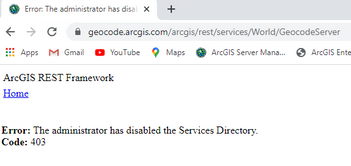
https://geocode.arcgis.com/arcgis/rest/services/World/GeocodeServer
Is this error linked to my below problem ?
I appreciate your support.
Dear Robert,
other observation, currently we are using Dev 2.21
where as the current version is 2.4
Does this have any impact, please advise me, Is it mandatory to upgrade Web App Builder Dev Edition to 2.4? or the tool can still work with 2.1?
Thank you,
@Aneel_Kumar_M To answer your question about Portal or AGOL this custom widget will only work in WAB Developer or Portal. Custom widgets are not allowed in AGOL. As far as version of WAB 2.21 or 2.24 either will work.
After you overwrote the wkidDetails.json file in the jimu client and the app folder that you are configuring the eLocate widget in did you restart and clear your browsers cache?
Dear Robert,
- I opened the application, removed the already configured tool
- saved and closed the bowser
- then opened the browser, then cleared the cache
- I gain added the tool to my application and saved
- then I tried to edit for changing the existing SR or to add new SR
- I got the same issue. is there anything else I need to do?
please advise, thank you for your support.
@Aneel_Kumar_M I am not sure what this issue is then. So the advice I have now is to just manually make the changes to the widgets json.
Open server\apps\3\configs\eLocate\config__x.json and change the wkid of the last point unit object (i.e.
{
        "wgs84option": "",
        "wkid": 26916,
        "ylabel": "Y:",
        "xlabel": "X:",
        "example": "608140.63, 3724298.41",
        "name": "NAD 1983 UTM 16N"
      }
to whatever wkid you are wanting and change the example and name properties as well. Restart WAB and you should be good to go.
Dear Robert,
Great, it worked, thank you so much.
Though, it was popping up permission error, for editing the config file, I try to edit in my local and overwrite it, but still file was not able to replace. So I did the below steps.
- Removed from the web app and saved it
- modified the config file in the eLocate widget folder
- Then added in to the web app
- tested and Its working now
I appreciate your continuous support.
Hi Robert. Referring to your response about USNG on 09-02-2016, is it possible to set up a USNG configuration in eLocate now? I'm in Developer 2.23, eLocate 2.16 and Server 10.9.1. If so, do you have information on how to do that? I'm coming up dry.
@AdamGebhart As there was never a demand for that except that one user it was never added.
Sounds good and I'll let our users know. Thanks for the reply.
Hello Robert!
I´m needing a WAB widget that calculates the distance between a point A and a point over a polyline layer, without using Network Analyst. I wonder if you have any widget that does this type of calculation.
I´ll really appreciate your help.
Regards,
Ermelinda
@ErmelindaEspinoza No I have not seem any capability to do this without Network Analyst.
IF ANYONE KNOWS or HAS VERSION 2.9. Please SHARE IT / upload it to this original thread 👇
Enhanced Locate Widget Version 2.16 - 08/21/2020
https://community.esri.com/t5/web-appbuilder-custom-widgets-documents/enhanced-locate-widget-version....
All the original links are broken.
I will tag @RobertScheitlin__GISP but I saw he has not logged on to the ESRI community since February of 2025.
Any help from the ESRI Community and this group would be greatly appreciated!
@Aneel_Kumar_M (by any chance do you still have it?)Looks like you were one of the last people in 2022 that communicated to Robert on this.
Thank you everyone in advance for your help!
The links have been repaired! Thank you @RobertScheitlin__GISP! Can download version 2.9. 👍
- « Previous
- Next »


