Turn on suggestions
Auto-suggest helps you quickly narrow down your search results by suggesting possible matches as you type.
Cancel
- Home
- :
- All Communities
- :
- Industries
- :
- State & Local Government
- :
- State & Local Government Questions
- :
- Re: Map Service Publishing Error
Options
- Subscribe to RSS Feed
- Mark Topic as New
- Mark Topic as Read
- Float this Topic for Current User
- Bookmark
- Subscribe
- Mute
- Printer Friendly Page
Map Service Publishing Error
Subscribe
6763
8
12-05-2012 03:46 AM
12-05-2012
03:46 AM
- Mark as New
- Bookmark
- Subscribe
- Mute
- Subscribe to RSS Feed
- Permalink
Hi all,
I am working with the Nov release of the LGIM and base maps. We have migrated our data over from the 10.0 model and are now working to publish the base maps as map services. In anticipation of a server upgrade we did not utilize the map services or apps for 10.0 opting to wait until we made a full transition to 10.1 SP1 (desktop and server).
The world of servers and map services is new to me. My GIS background until recently was in analysis and working with the data provided or created. I am excited to learn this side of GIS but have run into an issue when trying to publish the base maps as web services.
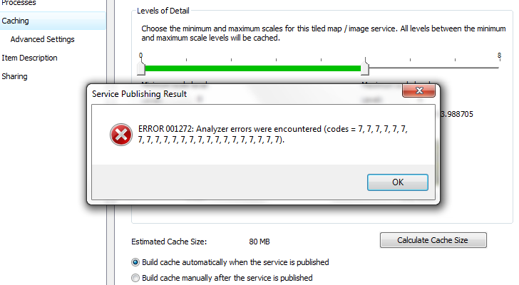
I have created several smaller test maps and published without any problems. I've been working with the General Purpose map as a test and for my learning. I've followed the instructions for publishing in the help files and all seems to go well until I get a critical Error 001272 (see image)
[ATTACH=CONFIG]19709[/ATTACH]
This comes during the "Creating Service Definition" part of the process. . In looking up the error code I came across a forum post that seemed to be similar in nature (Link to Forum Post). I've checked and both desktop and server have SP1 installed.
So question is, anyone else having this issue and what do I need to do, check, change to correct this error.
BTW when I run analyzer from the publish window I only get minor suggestions for improving performance and no errors.
Any thoughts and direction will be greatly appreciated.
Thanks,
DT
I am working with the Nov release of the LGIM and base maps. We have migrated our data over from the 10.0 model and are now working to publish the base maps as map services. In anticipation of a server upgrade we did not utilize the map services or apps for 10.0 opting to wait until we made a full transition to 10.1 SP1 (desktop and server).
The world of servers and map services is new to me. My GIS background until recently was in analysis and working with the data provided or created. I am excited to learn this side of GIS but have run into an issue when trying to publish the base maps as web services.
I have created several smaller test maps and published without any problems. I've been working with the General Purpose map as a test and for my learning. I've followed the instructions for publishing in the help files and all seems to go well until I get a critical Error 001272 (see image)
[ATTACH=CONFIG]19709[/ATTACH]
This comes during the "Creating Service Definition" part of the process. . In looking up the error code I came across a forum post that seemed to be similar in nature (Link to Forum Post). I've checked and both desktop and server have SP1 installed.
So question is, anyone else having this issue and what do I need to do, check, change to correct this error.
BTW when I run analyzer from the publish window I only get minor suggestions for improving performance and no errors.
Any thoughts and direction will be greatly appreciated.
Thanks,
DT
8 Replies
12-05-2012
10:29 AM
- Mark as New
- Bookmark
- Subscribe
- Mute
- Subscribe to RSS Feed
- Permalink
Okay an update.
I've been testing various options, settings, data layers today and found out the following. The error only occurs if somewhere in my map I have a definition query set that uses some type of physical measurement like length or area. I used the SHAPE.STArea() and SHAPE.STLength() in several layer definition queries. When I removed the definition queries the error went away and my sample map I created using just the layers in the reference feature set of the LGIM published as a map service with no issues.
To further test I went into my sample map and created a layer definition query based on a non measurement value. I used Facility Sites layer and set a definition query based on government facilities (to show only government facilities) I kept all other settings the same and published the map service. Like the one with all definition queries removed it published just fine.
So it looks like I have found what my problem is, layer definition queries using measurement values. Now I only have to figure out how to use those queries for better map drawing without getting the error message.
12-05-2012
11:31 AM
- Mark as New
- Bookmark
- Subscribe
- Mute
- Subscribe to RSS Feed
- Permalink
Just a quick easy question, did you remove the quotes from the SHAPE.STLength() and SHAPE.STArea() values? Also before you tried publishing did you click analyze to see if it came up with any errors? If it did or had some high notifications you might check those out to see if there is anything you can correct that might alleviate the critical error.
12-06-2012
08:33 AM
- Mark as New
- Bookmark
- Subscribe
- Mute
- Subscribe to RSS Feed
- Permalink
Just a quick easy question, did you remove the quotes from the SHAPE.STLength() and SHAPE.STArea() values? Also before you tried publishing did you click analyze to see if it came up with any errors? If it did or had some high notifications you might check those out to see if there is anything you can correct that might alleviate the critical error.
Good questions to check on. There were no quotes around the field names when published. Also I ran analyzer from ArcMap and from within the Service publishing window. Both times no Definition Query errors were reported. I did try once with quotes but of course that produced an syntax error on the query.
Today I went in and removed any Definition Queries that used the SHAPE.STArea() or SHAPE.STLength() fields at all map view scales. With them removed the map service published with no error. This is really strange to me since these fields are used in some of the SQL label definition processes but do not produce any error.
I'm good with removing the portion of Definition Queries that have this fields but concerned that it may have negative effects when we start to develop the various apps provided that hit off of these base maps.
So still looking for a way to make it work "out of the box"
Thanks for the reply.
12-10-2012
05:17 AM
- Mark as New
- Bookmark
- Subscribe
- Mute
- Subscribe to RSS Feed
- Permalink
I use those same fields in my basemaps so that's why I asked those questions because that's where I stumbled when we first set up our sde database. I would probably log a call with Customer Service on this one, it can be a long process especially if you're the first one to have the error, but it will hopefully produce results.
07-29-2013
05:24 AM
- Mark as New
- Bookmark
- Subscribe
- Mute
- Subscribe to RSS Feed
- Permalink
Duane,
Not to resurrect an old thread, but I just wanted to confirm that I am have encountered this same issue as well. Up until now, I have been publishing our local gov basemaps from a file gdb. We have since moved it to an enterprise database to help make the updating process a little easier. Since trying to publish the basemaps from the sde database, I have come across the same errors with the geometry queries on the SHAPE.STArea and SHAPE.STLength fields. I do find it odd that ESRI included these queries in their basemaps, and never came across the bug before release. Surely they must have tested in an enterprise environment?
Did you ever find a satisfactory workaround?
Thanks,
Andrew
08-05-2013
04:00 AM
- Mark as New
- Bookmark
- Subscribe
- Mute
- Subscribe to RSS Feed
- Permalink
Andrew,
We did find that the suggestion of saving as a Def Service file then publish the service from the Def file does work. Still a pain because we cannot overwrite teh existing service. So we have to delete the cache, then the service, then publish from an updated service def file when ever we want to update a cache. Slightly awkward workflow, but it does work.
Duane
08-26-2013
12:39 PM
- Mark as New
- Bookmark
- Subscribe
- Mute
- Subscribe to RSS Feed
- Permalink
Thanks for the response, Duane. I couldn't get that workflow to work for me, so I ended up just deleting my queries on the Shape fields. Makes my basemap look slightly sloppier, but it gets me past the bug.
08-27-2013
12:09 PM
- Mark as New
- Bookmark
- Subscribe
- Mute
- Subscribe to RSS Feed
- Permalink
This is a known issue at 10.1 (NIM082764) that has been resolved with the 10.2 release of ArcGIS for Server. To publish the General Purpose basemap (or any map service with an SDE data source and definition queries on geometry fields) using ArcGIS for Server 10.1, here are some suggested workarounds:
1. As you�??ve discovered, removing the definition query avoids the error message. You can also create alternate fields to use in the query. For example, a numeric field that holds the same values as the geometry field or a true/false field based on the threshold for the original query.
2. This issue has been resolved with the 10.2 release of ArcGIS for Server, so upgrading will allow you to use the original queries in the map documents (with modifications to correctly reference SDE fields, of course)
This is actually an ArcGIS for Server issue - not ArcGIS for Local Government. A related post with more information can be found on the Server forum:
ERROR 001272: Analyzer errors were encountered (codes = 7)
Cheers,
Allison M