- Home
- :
- All Communities
- :
- Developers
- :
- Python
- :
- Python Questions
- :
- Write ArcPy cursor results to a text file in diffe...
- Subscribe to RSS Feed
- Mark Topic as New
- Mark Topic as Read
- Float this Topic for Current User
- Bookmark
- Subscribe
- Mute
- Printer Friendly Page
Write ArcPy cursor results to a text file in different folders with a different name based on cursor condition. Define function is not working.Multiprocessing
- Mark as New
- Bookmark
- Subscribe
- Mute
- Subscribe to RSS Feed
- Permalink
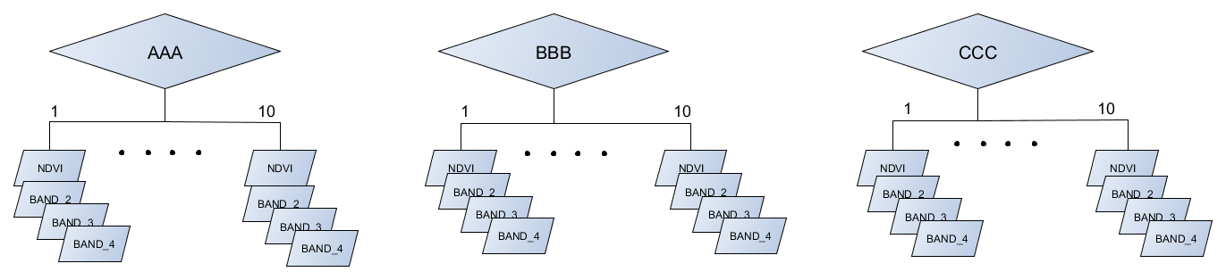
Middle section of the code, I separate the attribute value in a different category ("AAA","BBB","CCC") and every category have Ten land-use types, initially, I set Three land use type (LAND_10, LAND_20, LAND_30) for test code. Now I used the update cursor for different land-use type(LAND_10, LAND_20, LAND_30) , and saved the text file to there corresponding Land use folders(Like, Land_10 ....Land_30) under the "AAA" folder. similarly, this function I will use for categories "BBB","CCC" .
Initially, I write this code for category "AAA" but I want to use this function for category "BBB","CCC" by defining a function(uncheck all define function), but is not working. Below is my code please check it.
First of all, I want to reduce my code (Because I have 10 land type initially I write three) and the whole function I want to use as a defined function for a different category.
Another thing is Multiprocessing, Multithreading I want to use this function for the code because of initially my code takes much more time for one processes. In my case how to use the multiprocessing function.
please look at this matter and give me a suggestion to manipulate this code.
import datetime
start = datetime.datetime.now()
print 'start run: %s\n' % (start)
import arcpy ,os ,sys,csv,errno
from arcpy import env
from arcpy.sa import *
import datetime
import re
import glob
import itertools
arcpy.env.overwriteOutput = True
import multiprocessing as mp
print("Number of processors: ", mp.cpu_count())
cellsize = "F:\\DB_test_data\\TEST_RAY\\TEST1\\MOD02HKM_A2017001_0530_NDVI_AA.img"
d1="F:\\DB_test_data\\VAR2\\cldmask\\tt"
CLDMASK = glob.glob(d1 + os.sep + "*.Aerosol_Cldmask_Land_Ocean-Aerosol_Cldmask_Land_Ocean.tif")
CLDMASK.sort()
if CLDMASK is None:
print 'Could not open the CLDMASK raster files'
sys.exit(1)
else:
print 'The CLDMASK raster files was opened successfully'
#print CLDMASK
d2="F:\\DB_test_data\\TEST_RAY\\TEST1"
NDVI = glob.glob(d2 + os.sep + "*A2017001_0530_NDVI_AA.img")
NDVI.sort()
if NDVI is None:
print 'Could not open the NDVI raster files'
sys.exit(1)
else:
print 'The NDVI raster files was opened successfully'
#print NDVI
d3="F:\\DB_test_data\\VAR2\\IDL\\MOD02HKM\\TEST"
BAND1 = glob.glob(d3 + os.sep + "*A2017001_0530_006_BAND_1.img")
BAND1.sort()
if BAND1 is None:
print 'Could not open the BAND1 raster files'
sys.exit(1)
else:
print 'The BAND1 raster files was opened successfully'
#print BAND1
d4="F:\\DB_test_data\\VAR2\\IDL\\MOD02HKM\\TEST"
BAND2 = glob.glob(d4 + os.sep + "*A2017001_0530_006_BAND_2.img")
BAND2.sort()
if BAND2 is None:
print 'Could not open the BAND2 raster files'
sys.exit(1)
else:
print 'The BAND2 raster files was opened successfully'
#print BAND2
d4="F:\\DB_test_data\\VAR2\\IDL\\MOD09\\TEST"
BAND3 = glob.glob(d4 + os.sep + "*A2017001_0530_006_BAND_3.img")
BAND3.sort()
if BAND3 is None:
print 'Could not open the BAND3 raster files'
sys.exit(1)
else:
print 'The BAND3 raster files was opened successfully'
#print BAND3
d5="F:\\DB_test_data\\VAR2\\IDL\\MOD02HKM\\TEST"
BAND4 = glob.glob(d5 + os.sep + "*A2017001_0530_006_BAND_4.img")
BAND4.sort()
if BAND4 is None:
print 'Could not open the BAND4 raster files'
sys.exit(1)
else:
print 'The BAND4 raster files was opened successfully'
#print BAND4
d6 = r"F:\\DB_test_data\\VAR2\\MOD04_l2"
AOD = glob.glob(d6 + os.sep + "*Corrected_Optical_Depth_Land_2-Corrected_Optical_Depth_Land.tif")
AOD.sort()
if AOD is None:
print 'Could not open the AOD raster files'
sys.exit(1)
else:
print 'The AOD raster files was opened successfully'
Scale_factor = float(0.0010000000474974513)
add_offset = float(0.0)
Fill_value = float(-9999)
outdir="F:\\DB_test_data\\VAR4\\"
for a,b,c,d,e,f,g in zip (CLDMASK ,NDVI ,BAND1 ,BAND2 ,BAND3 ,BAND4,AOD):
print ("processing:"+ a)
arcpy.AddMessage("processing:{}".format(b.split('\\')[4][9:30]))
name = c.split("\\")
filename=name[6][9:33]
print filename
arcpy.AddMessage("processing:{}".format(d.split('\\')[6][9:33]))
arcpy.AddMessage("processing:{}".format(e.split('\\')[6][9:30]))
arcpy.AddMessage("processing:{}".format(f.split('\\')[6][9:33]))
print ("processing:"+ g)
#######################################################################
setnull =arcpy.gp.SetNull_sa(g,g, "in_memory/dat", "\"Value\" = -9999")
ras=arcpy.Raster(setnull)
Data=(ras-add_offset)*Scale_factor
da = Con((Data >= 0.0) & (Data <= 0.1),1)
# Process: Extract by Cloud_Mask
tempEnvironment0 = arcpy.env.cellSize
arcpy.env.cellSize = "MAXOF"
ndvi_msk=arcpy.gp.ExtractByMask_sa(b, a)
Band1_mask=arcpy.gp.ExtractByMask_sa(c, a)
Band2_mask=arcpy.gp.ExtractByMask_sa(d, a)
Band3_mask=arcpy.gp.ExtractByMask_sa(e, a)
Band4_mask=arcpy.gp.ExtractByMask_sa(f, a)
arcpy.env.cellSize = tempEnvironment0
# Process: Extract by Mask using AOD less than 0.1 value
tempEnvironment0 = arcpy.env.cellSize
arcpy.env.cellSize = cellsize
ndvi_msk1=arcpy.gp.ExtractByMask_sa(ndvi_msk, da)
Band1_mask1=arcpy.gp.ExtractByMask_sa(Band1_mask, da)
Band2_mask2=arcpy.gp.ExtractByMask_sa(Band2_mask, da)
Band3_mask3=arcpy.gp.ExtractByMask_sa(Band2_mask, da)
Band4_mask4=arcpy.gp.ExtractByMask_sa(Band2_mask, da)
arcpy.env.cellSize = tempEnvironment0
try:
# Raster to point
field ="VALUE"
Point=arcpy.RasterToPoint_conversion(ndvi_msk1,"in_memory/fileroot",field)
shape=arcpy.sa.ExtractMultiValuesToPoints(Point,[[ndvi_msk1,"NDVI"],[Band1_mask1,"Band1"],[Band2_mask2,"Band2"],
[Band3_mask3 ,"Band3"],[Band4_mask4,"Band4"]], "NONE")
#Add Two Fields Name and Name2
[arcpy.AddField_management(shape,field_name, "TEXT", field_length = 50)
for field_name in ["Name", "Name2"]]
arcpy.AddMessage("Successfully Added NAME fields ")
fieldss = ['Band1','Name']
with arcpy.da.UpdateCursor(shape, fieldss) as cursor:
for row in cursor:
if (row[0] > 0.02 and row[0] < 0.06):
row[1] = 'AAA'
print ("processing1:""{0:.8f}, {1}".format(row[0], row[1]))
elif (row[0] >= 0.06 and row[0] < 0.09):
row[1] = 'BBB'
# print ("processing1:""{0:.8f}, {1}".format(row[0], row[1]))
elif (row[0] >= 0.09):
row[1] = 'CCC'
else:
row[1] = 'NA'
# Update the cursor with the updated list
cursor.updateRow(row)
# Process: Select Layer By Attribute for separate the catagories "AAA","BBB,"CCC"
arcpy.MakeFeatureLayer_management(shape,"lyr1")
AAA = arcpy.SelectLayerByAttribute_management("lyr1", "NEW_SELECTION", "\"Name\" = 'AAA'")
print "Successfully Process : Select Layer By Attribute for AAA "
arcpy.MakeFeatureLayer_management(shape,"lyr2")
BBB = arcpy.SelectLayerByAttribute_management("lyr2", "NEW_SELECTION", "\"Name\" = 'BBB'")
print "Successfully Process : Select Layer By Attribute for BBB "
arcpy.MakeFeatureLayer_management(shape,"lyr3")
CCC = arcpy.SelectLayerByAttribute_management("lyr3", "NEW_SELECTION", "\"Name\" = 'CCC'")
print "Successfully Process : Select Layer By Attribute for CCC "
# Writing tables for categories("AAA","BBB,"CCC") and individual category have three Land type
# that will be save in different folder and their individual name
#------------------First we write category "AAA" and their indiviual land type--------------------------------------#
category="AAA"
file_name=filename
base_path = r"F:\\DB_test_data\\VAR4\\"
#def TableTotext(Input_Data,base_path,category,file_name):
#def Land_10():
land_use='LAND_10'
outdir = os.path.join(base_path,category,land_use)
if not os.path.exists(outdir):
print('\nCreating new output directory!\n'+outdir+'\n')
os.makedirs(outdir)
else:
print ("Directory already exists" )
ras_name = os.path.join(outdir,("{0}_{1}{2}_{3}".format(category,file_name,land_use,".txt")))
fields = ['NDVI', 'Band1', 'Band2','Band3','Name',"Name2"]
with open(ras_name, 'wb') as txtfile:
arcpy.AddMessage("fields Writing For landuse 10")
txtfile.write(" {0} {1} {2} {3} {4} {5}\n".format(fields[0],fields[1],fields[2],fields[3],fields[4],fields[5]))
with arcpy.da.UpdateCursor(AAA, fields) as cursor:
for row in cursor:
if (row[0] > 0.10 and row[0] < 0.20):
row[5] = 'landuse_10'
print ("processing_A:""{0:.8f} {1:.8f} {2:.8f} {3:.8f} {4} {5}".format(row[0],row[1],row[2], row[3],row[4],row[5]))
txtfile.write("{0:.8f} {1:.8f} {2:.8f} {3:.8f} {4} {5}\n".format(row[0],row[1],row[2], row[3],row[4],row[5]))
txtfile.close()
print ("Successfully save the landuse 10 " )
#return Land_10
#def Land_20():
land_use='LAND_20'
outdir = os.path.join(base_path,category,land_use)
if not os.path.exists(outdir):
print('\nCreating new output directory!\n'+outdir+'\n')
os.makedirs(outdir)
else:
print ("Directory already exists" )
ras_name = os.path.join(outdir,("{0}_{1}{2}_{3}".format(category,file_name,land_use,".txt")))
fields = ['NDVI', 'Band1', 'Band2','Band3','Name',"Name2"]
with open(ras_name, 'wb') as txtfile:
arcpy.AddMessage("fields Writing For landuse 20")
txtfile.write(" {0} {1} {2} {3} {4} {5}\n".format(fields[0],fields[1],fields[2],fields[3],fields[4],fields[5]))
with arcpy.da.UpdateCursor(AAA, fields) as cursor:
for row in cursor:
if (row[0] >= 0.20 and row[0] < 0.50):
row[5] = 'landuse_20'
print ("processing_B:""{0:.8f} {1:.8f} {2:.8f} {3:.8f} {4} {5}".format(row[0],row[1],row[2], row[3],row[4],row[5]))
txtfile.write("{0:.8f} {1:.8f} {2:.8f} {3:.8f} {4} {5}\n".format(row[0],row[1],row[2], row[3],row[4],row[5]))
txtfile.close()
print ("Successfully save the landuse 20 " )
#return Land_20
#def Land_30():
land_use='LAND_30'
outdir = os.path.join(base_path,category,land_use)
if not os.path.exists(outdir):
print('\nCreating new output directory!\n'+outdir+'\n')
os.makedirs(outdir)
else:
print ("Directory already exists" )
ras_name = os.path.join(outdir,("{0}_{1}{2}_{3}".format(category,file_name,land_use,".txt")))
fields = ['NDVI', 'Band1', 'Band2','Band3','Name',"Name2"]
with open(ras_name, 'wb') as txtfile:
arcpy.AddMessage("fields Writing For landuse 30")
txtfile.write(" {0} {1} {2} {3} {4} {5}\n".format(fields[0],fields[1],fields[2],fields[3],fields[4],fields[5]))
with arcpy.da.UpdateCursor(AAA, fields) as cursor:
for row in cursor:
if (row[0] >= 0.50):
row[5] = 'landuse_30'
print ("processing_C:""{0:.8f} {1:.8f} {2:.8f} {3:.8f} {4} {5}".format(row[0],row[1],row[2], row[3],row[4],row[5]))
txtfile.write("{0:.8f} {1:.8f} {2:.8f} {3:.8f} {4} {5}\n".format(row[0],row[1],row[2], row[3],row[4],row[5]))
txtfile.close()
print ("Successfully save the landuse 30 " )
#return LAND_30
#------------------Second we write category "BBB" and their indiviual land type--------------------------------------#
print "Code is OK"
except:
print "Error in Code"
print arcpy.GetMessages()
print 'finished run: %s\n\n' % (datetime.datetime.now() - start)
Solved! Go to Solution.
- Mark as New
- Bookmark
- Subscribe
- Mute
- Subscribe to RSS Feed
- Permalink
Can I assume that my code has no further improvement in this context and I will Write more Ten geoprocess functions? Another thing, there is any option to use the multiprocessing function? Please, sir, give me a final suggestion regarding this code because I am waiting for it. Joshua Bixby Dan PattersonXander Bakker
- Mark as New
- Bookmark
- Subscribe
- Mute
- Subscribe to RSS Feed
- Permalink
Its a complex task to analyse your code, its very long as you say!
But, I looked at GeoProcess 1, 2 and 3. They looked the same except you change a couple of variable: (You will know better what changes in each function)
land_use='LAND_10'land_use='LAND_30' if (row[0] >= 0.20 and row[0] < 0.50):if (row[0] > 0.10 and row[0] < 0.20):etc etc.
So, if the functions are doing the same thing, with slightly different variables, table names, etc. Then no, you should not code 10 more functions, you should add an extra variable to your code.
def geoprocess(base_path,category,file_name,file, land_use, tolerance_minimum, tolerance_maximum):Then, you can reuse this function as you need by "Calling" it from the main script. e.g.
process1 = geoprocess(base_path,category,file_name,file,'LAND_10', 0.2, 0.5)process2 = geoprocess(base_path,category,file_name,file,'LAND_20', 0.1, 0.2)process3 = geoprocess(base_path,category,file_name,file,'LAND_30', etc, etc)process4 = geoprocess(etc)
- Mark as New
- Bookmark
- Subscribe
- Mute
- Subscribe to RSS Feed
- Permalink
Luke Webb sir I am trying to flow your instruction as per your mentioning comments. I seem that geoprocesses 1,2,3 have a different different argument.
geoprocess1 have greater than and less than sign
if (row[0] > 0.10 and row[0] < 0.20):geoprocess2 have greater than equal and less than sign
if (row[0] >= 0.20 and row[0] < 0.50):geoprocess3 have greater than equal sign
if (row[0] >= 0.50):That's why we cannot write one single def function for every geoprocess(1 to3) please check this code
import datetime
start = datetime.datetime.now()
print 'start run: %s\n' % (start)
import arcpy ,os ,sys,csv,errno
from arcpy import env
from arcpy.sa import *
import datetime
import re
import glob
import itertools
arcpy.env.overwriteOutput = True
import multiprocessing
print("Number of processors: ", multiprocessing.cpu_count())
try:
point_shp=r"F:\\DB_test_data\\VAR4\\VAR4.shp"
[arcpy.AddField_management(point_shp,field_name, "TEXT", field_length = 50)
for field_name in ["Name", "Name2"]]
arcpy.AddMessage("Successfully Added NAME fields ")
fieldss = ['Band1','Name']
with arcpy.da.UpdateCursor(point_shp, fieldss) as cursor:
for row in cursor:
if (row[0] > 0.02 and row[0] < 0.05):
row[1] = 'AAA'
print ("processing1:""{0:.8f}, {1}".format(row[0], row[1]))
elif (row[0] >= 0.05 and row[0] < 0.09):
row[1] = 'BBB'
## print ("processing1:""{0:.8f}, {1}".format(row[0], row[1]))
elif (row[0] >= 0.09):
row[1] = 'CCC'
else:
row[1] = 'NA'
# Update the cursor with the updated list
cursor.updateRow(row)
# Process: Select Layer By Attribute for separate the catagories "AAA","BBB,"CCC"
arcpy.MakeFeatureLayer_management(point_shp,"lyr1")
AAA = arcpy.SelectLayerByAttribute_management("lyr1", "NEW_SELECTION", "\"Name\" = 'AAA'")
print "Successfully Process : Select Layer By Attribute for AAA "
arcpy.MakeFeatureLayer_management(point_shp,"lyr2")
BBB = arcpy.SelectLayerByAttribute_management("lyr2", "NEW_SELECTION", "\"Name\" = 'BBB'")
print "Successfully Process : Select Layer By Attribute for BBB "
arcpy.MakeFeatureLayer_management(point_shp,"lyr3")
CCC = arcpy.SelectLayerByAttribute_management("lyr3", "NEW_SELECTION", "\"Name\" = 'CCC'")
print "Successfully Process : Select Layer By Attribute for CCC "
category="xxx"
file_name="MOD02HKM_2017_01"
base_path = r"F:\\DB_test_data\\VAR4\\"
Input_Data = point_shp
def geoprocess (Input_Data,base_path,category,land_use,tolerance_minimum, tolerance_maximum):
#land_use='LAND_10'
outdir = os.path.join(base_path,category,land_use)
if not os.path.exists(outdir):
try:
print('\nCreating new output directory!\n'+outdir+'\n')
os.makedirs(outdir)
except OSError:
print ("Creation of the directory failed" )
else:
print ("Successfully created the directory" )
ras_name = os.path.join(outdir,("{0}_{1}{2}_{3}".format(category,file_name,land_use,".txt")))
fields = ['grid_code', 'Band1', 'Band2','Band3','Name',"Name2"]
with open(ras_name, 'wb') as txtfile:
arcpy.AddMessage("fields Writing For landuse 10")
txtfile.write(" {0} {1} {2} {3} {4} {5}\n".format(fields[0],fields[1],fields[2],fields[3],fields[4],fields[5]))
with arcpy.da.UpdateCursor(Input_Data, fields) as cursor:
for row in cursor:
if (row[0] > tolerance_minimum and row[0] < tolerance_maximum):
row[5] = land_use
print ("processing_A:""{0:.8f} {1:.8f} {2:.8f} {3:.8f} {4} {5}".format(row[0],row[1],row[2], row[3],row[4],row[5]))
txtfile.write(" {0:.8f} {1:.8f} {2:.8f} {3:.8f} {4} {5}\n".format(row[0],row[1],row[2], row[3],row[4],row[5]))
txtfile.close()
print ("Successfully save the landuse 10 " )
print "Code is OK"
except:
print "Error in code"
def main(base_path,category,file_name,file):
geoprocess(base_path,category,file_name,file, 'LAND_10', 0.1, 0.20)
geoprocess(base_path,category,file_name,file, 'LAND_20', 0.20,0.50)
geoprocess(base_path,category,file_name,file, 'LAND_30', 0.50, tolerance_maximum)
try:
if __name__ == '__main__':
t1=time.time()
main(base_path,"AAA",file_name,AAA)
main(base_path,"BBB",file_name,BBB)
main(base_path,"CCC",file_name,CCC)
print "serial processing took:",time.time()-t1
print "serial processing is OK"
except:
print "Error in serial processing"
print arcpy.GetMessages()
print 'finished run: %s\n\n' % (datetime.datetime.now() - start)
- Mark as New
- Bookmark
- Subscribe
- Mute
- Subscribe to RSS Feed
- Permalink
Each of your geoprocess functions is 31 lines, and they effectively only differ from each other in 1 line. Writing the same 30+ lines of code 10 times not only takes up unnecessary space, it makes reading and maintaining the code much more difficult. I suggest you take the label, e.g., 'LAND_30', and the conditional check and make them parameters of the function; then, you can loop and call the function 10 times instead of creating 10 separate but nearly identical functions.
- Mark as New
- Bookmark
- Subscribe
- Mute
- Subscribe to RSS Feed
- Permalink
Thank you, sir, for your swift response. I will try to make this conditional loop as per your instruction.
- Mark as New
- Bookmark
- Subscribe
- Mute
- Subscribe to RSS Feed
- Permalink
Joshua Bixby sir, I am a little bit confused to write your mentioning for loop and conditional statement for different geoprocess(1,2,3).
arcpy.MakeFeatureLayer_management(shape,"lyr1")
AAA = arcpy.SelectLayerByAttribute_management("lyr1", "NEW_SELECTION", "\"Name\" = 'AAA'")
print "Successfully Process : Select Layer By Attribute for AAA "
arcpy.MakeFeatureLayer_management(shape,"lyr2")
BBB = arcpy.SelectLayerByAttribute_management("lyr2", "NEW_SELECTION", "\"Name\" = 'BBB'")
print "Successfully Process : Select Layer By Attribute for BBB "
arcpy.MakeFeatureLayer_management(shape,"lyr3")
CCC = arcpy.SelectLayerByAttribute_management("lyr3", "NEW_SELECTION", "\"Name\" = 'CCC'")
print "Successfully Process : Select Layer By Attribute for CCC "
# Writing tables for categories("AAA","BBB,"CCC") and individual category have three Land type
# that will be save in different folder and their individual name
#------------------First we write category "AAA" and their indiviual land type--------------------------------------#
def geoprocess1(base_path,category,file_name,file):
try:
land_use='LAND_10'
outdir = os.path.join(base_path,category,land_use)
if not os.path.exists(outdir):
try:
print('\nCreating new output directory!\n'+outdir+'\n')
os.makedirs(outdir)
except OSError:
print ("Creation of the directory failed" )
else:
print ("Successfully created the directory" )
ras_name = os.path.join(outdir,("{0}_{1}{2}_{3}".format(category,file_name,land_use,".txt")))
fields = ['grid_code', 'Band1', 'Band2','Band3','Name',"Name2"]
with open(ras_name, 'wb') as txtfile:
arcpy.AddMessage("fields Writing For landuse 10")
txtfile.write(" {0} {1} {2} {3} {4} {5}\n".format(fields[0],fields[1],fields[2],fields[3],fields[4],fields[5]))
with arcpy.da.UpdateCursor(file, fields) as cursor:
for row in cursor:
if (row[0] > 0.10 and row[0] < 0.20):
row[5] = 'landuse_10'
print ("processing_A:""{0:.8f} {1:.8f} {2:.8f} {3:.8f} {4} {5}".format(row[0],row[1],row[2], row[3],row[4],row[5]))
txtfile.write(" {0:.8f} {1:.8f} {2:.8f} {3:.8f} {4} {5}\n".format(row[0],row[1],row[2], row[3],row[4],row[5]))
txtfile.close()
print ("Successfully save the landuse 10 " )
print('Sucess: geoprocess1 complete!')
except Exception as err:
print('Error: unable to complete geoprocess1')
print(err)
def geoprocess2(base_path,category,file_name,file):
try:
land_use='LAND_20'
outdir = os.path.join(base_path,category,land_use)
if not os.path.exists(outdir):
try:
print('\nCreating new output directory!\n'+outdir+'\n')
os.makedirs(outdir)
except OSError:
print ("Creation of the directory failed" )
else:
print ("Successfully created the directory" )
ras_name = os.path.join(outdir,("{0}_{1}{2}_{3}".format(category,file_name,land_use,".txt")))
fields = ['grid_code', 'Band1', 'Band2','Band3','Name',"Name2"]
with open(ras_name, 'wb') as txtfile:
arcpy.AddMessage("fields Writing For landuse 20")
txtfile.write(" {0} {1} {2} {3} {4} {5}\n".format(fields[0],fields[1],fields[2],fields[3],fields[4],fields[5]))
with arcpy.da.UpdateCursor(file, fields) as cursor:
for row in cursor:
if (row[0] >= 0.20 and row[0] < 0.50):
row[5] = 'landuse_20'
print ("processing_B:""{0:.8f} {1:.8f} {2:.8f} {3:.8f} {4} {5}".format(row[0],row[1],row[2], row[3],row[4],row[5]))
txtfile.write(" {0:.8f} {1:.8f} {2:.8f} {3:.8f} {4} {5}\n".format(row[0],row[1],row[2], row[3],row[4],row[5]))
txtfile.close()
print ("Successfully save the landuse 20 " )
print('Sucess: geoprocess2 complete!')
except Exception as err:
print('Error: unable to complete geoprocess2')
print(err)
def geoprocess3(base_path,category,file_name,file):
try:
land_use='LAND_30'
outdir = os.path.join(base_path,category,land_use)
if not os.path.exists(outdir):
try:
print('\nCreating new output directory!\n'+outdir+'\n')
os.makedirs(outdir)
except OSError:
print ("Creation of the directory failed" )
else:
print ("Successfully created the directory" )
ras_name = os.path.join(outdir,("{0}_{1}{2}_{3}".format(category,file_name,land_use,".txt")))
fields = ['grid_code', 'Band1', 'Band2','Band3','Name',"Name2"]
with open(ras_name, 'wb') as txtfile:
arcpy.AddMessage("fields Writing For landuse 30")
txtfile.write(" {0} {1} {2} {3} {4} {5}\n".format(fields[0],fields[1],fields[2],fields[3],fields[4],fields[5]))
with arcpy.da.UpdateCursor(file, fields) as cursor:
for row in cursor:
if (row[0] >= 0.50):
row[5] = 'landuse_30'
print ("processing_C:""{0:.8f} {1:.8f} {2:.8f} {3:.8f} {4} {5}".format(row[0],row[1],row[2], row[3],row[4],row[5]))
txtfile.write(" {0:.8f} {1:.8f} {2:.8f} {3:.8f} {4} {5}\n".format(row[0],row[1],row[2], row[3],row[4],row[5]))
txtfile.close()
print ("Successfully save the landuse 30 " )
print('Sucess: geoprocess3 complete!')
except Exception as err:
print('Error: unable to complete geoprocess3')
print(err)
def main(base_path,category,file_name,file):
geoprocess1(base_path,category,file_name,file)
geoprocess2(base_path,category,file_name,file)
geoprocess3(base_path,category,file_name,file)
#category="AAA"
file_name=filename
base_path = r"F:\\DB_test_data\\VAR4\\"
try:
if __name__ == "__main__":
t1=time.time()
main(base_path,"AAA",file_name,AAA)
main(base_path,"BBB",file_name,BBB)
main(base_path,"CCC",file_name,CCC)
print "serial processing took:",time.time()-t1- Mark as New
- Bookmark
- Subscribe
- Mute
- Subscribe to RSS Feed
- Permalink
You mention there are 10 categories, how do you define them all?
- Mark as New
- Bookmark
- Subscribe
- Mute
- Subscribe to RSS Feed
- Permalink
Code flow
Sir Joshua Bixby if you notice my previous code here initially I define three land type corresponding Geoprocesses 1,2,3
def geoprocess1(base_path,category,file_name,file,land_use):
try:
#land_use='LAND_10'
outdir = os.path.join(base_path,category,land_use)
if not os.path.exists(outdir):
try:
print('\nCreating new output directory!\n'+outdir+'\n')
os.makedirs(outdir)
except OSError:
print ("Creation of the directory failed" )
else:
print ("Successfully created the directory" )
ras_name = os.path.join(outdir,("{0}_{1}{2}_{3}".format(category,file_name,land_use,".txt")))
fields = ['grid_code', 'Band1', 'Band2','Band3','Name',"Name2"]
with open(ras_name, 'wb') as txtfile:
arcpy.AddMessage("fields Writing For landuse 10")
txtfile.write(" {0} {1} {2} {3} {4} {5}\n".format(fields[0],fields[1],fields[2],fields[3],fields[4],fields[5]))
with arcpy.da.UpdateCursor(file, fields) as cursor:
for row in cursor:
if (row[0] > 0.10 and row[0] < 0.20):
row[5] = land_use
print ("processing_A:""{0:.8f} {1:.8f} {2:.8f} {3:.8f} {4} {5}".format(row[0],row[1],row[2], row[3],row[4],row[5]))
txtfile.write(" {0:.8f} {1:.8f} {2:.8f} {3:.8f} {4} {5}\n".format(row[0],row[1],row[2], row[3],row[4],row[5]))
txtfile.close()
print ("Successfully save the landuse 10 " )
print('Sucess: geoprocess1 complete!')
except Exception as err:
print('Error: unable to complete geoprocess1')
print(err)
def geoprocess2(base_path,category,file_name,file,land_use):
try:
#land_use='LAND_20'
outdir = os.path.join(base_path,category,land_use)
if not os.path.exists(outdir):
try:
print('\nCreating new output directory!\n'+outdir+'\n')
os.makedirs(outdir)
except OSError:
print ("Creation of the directory failed" )
else:
print ("Successfully created the directory" )
ras_name = os.path.join(outdir,("{0}_{1}{2}_{3}".format(category,file_name,land_use,".txt")))
fields = ['grid_code', 'Band1', 'Band2','Band3','Name',"Name2"]
with open(ras_name, 'wb') as txtfile:
arcpy.AddMessage("fields Writing For landuse 20")
txtfile.write(" {0} {1} {2} {3} {4} {5}\n".format(fields[0],fields[1],fields[2],fields[3],fields[4],fields[5]))
with arcpy.da.UpdateCursor(file, fields) as cursor:
for row in cursor:
if (row[0] >= 0.20 and row[0] < 0.50):
row[5] = land_use
print ("processing_B:""{0:.8f} {1:.8f} {2:.8f} {3:.8f} {4} {5}".format(row[0],row[1],row[2], row[3],row[4],row[5]))
txtfile.write(" {0:.8f} {1:.8f} {2:.8f} {3:.8f} {4} {5}\n".format(row[0],row[1],row[2], row[3],row[4],row[5]))
txtfile.close()
print ("Successfully save the landuse 20 " )
print('Sucess: geoprocess2 complete!')
except Exception as err:
print('Error: unable to complete geoprocess2')
print(err)
def geoprocess3(base_path,category,file_name,file,land_use):
try:
#land_use='LAND_30'
outdir = os.path.join(base_path,category,land_use)
if not os.path.exists(outdir):
try:
print('\nCreating new output directory!\n'+outdir+'\n')
os.makedirs(outdir)
except OSError:
print ("Creation of the directory failed" )
else:
print ("Successfully created the directory" )
ras_name = os.path.join(outdir,("{0}_{1}{2}_{3}".format(category,file_name,land_use,".txt")))
fields = ['grid_code', 'Band1', 'Band2','Band3','Name',"Name2"]
with open(ras_name, 'wb') as txtfile:
arcpy.AddMessage("fields Writing For landuse 30")
txtfile.write(" {0} {1} {2} {3} {4} {5}\n".format(fields[0],fields[1],fields[2],fields[3],fields[4],fields[5]))
with arcpy.da.UpdateCursor(file, fields) as cursor:
for row in cursor:
if (row[0] >= 0.50):
row[5] = land_use
print ("processing_C:""{0:.8f} {1:.8f} {2:.8f} {3:.8f} {4} {5}".format(row[0],row[1],row[2], row[3],row[4],row[5]))
txtfile.write(" {0:.8f} {1:.8f} {2:.8f} {3:.8f} {4} {5}\n".format(row[0],row[1],row[2], row[3],row[4],row[5]))
txtfile.close()
print ("Successfully save the landuse 30 " )and it defines into the main function as like this.
def main(base_path,category,file_name,file):
geoprocess1(base_path,category,file_name,file,"LAND_10")
geoprocess2(base_path,category,file_name,file,"LAND_20")
geoprocess3(base_path,category,file_name,file,"LAND_30")Further, I use this main function Into the three categories "AAA","BBB","CCC".
try:
if __name__ == "__main__":
t1=time.time()
main(base_path,"AAA",file_name,AAA)
main(base_path,"BBB",file_name,BBB)
main(base_path,"CCC",file_name,CCC)
print "serial processing took:",time.time()-t1Initially, you can make the for loop and conditional statement for different geoprocess(1,2,3) after that I will make another seven geoprocesses.
- Mark as New
- Bookmark
- Subscribe
- Mute
- Subscribe to RSS Feed
- Permalink
Thank you so much, sir. That's a great trick. I will manipulate my code as per your instruction.
Sir have any way to use the multiprocessing function in the main function(Combine of GeoProcess 1 to 10)?
- Mark as New
- Bookmark
- Subscribe
- Mute
- Subscribe to RSS Feed
- Permalink
You are getting ahead of yourself by focusing on multiprocessing. Optimize the code for serial/single processing, then look into using multiprocessing. Also, multiprocessing will not give you the gains you expect. If all of the threads or processes are accessing the same dataset or datasets on the same disks, you will get I/O contention at the file system level. The I/O contention will cause the threads or processes to wait. You will likely see speed increases of 3x or less, and I have even seem multiprocessing be slower than single processing when the analysis is disk I/O intensive.