- Home
- :
- All Communities
- :
- Developers
- :
- Python
- :
- Python Questions
- :
- Re: Unexpected Behavior with arcpy.addDataFromPath
- Subscribe to RSS Feed
- Mark Topic as New
- Mark Topic as Read
- Float this Topic for Current User
- Bookmark
- Subscribe
- Mute
- Printer Friendly Page
Unexpected Behavior with arcpy.addDataFromPath
- Mark as New
- Bookmark
- Subscribe
- Mute
- Subscribe to RSS Feed
- Permalink
Working on a work-around for another conundrum and tried the following:
import arcpy
x = some X
y = some Y
point = arcpy.Point(x,y)
ptGeometry = arcpy.PointGeometry(point)
feature_class = arcpy.CreateFeatureclass_management("in_memory", "tempfc", "POINT")[0]
with arcpy.da.InsertCursor(feature_class, ["SHAPE@XY"]) as cursor:
cursor.insertRow(ptGeometry)
aprx = arcpy.mp.ArcGISProject("CURRENT")
symbologyLayer = r"<some path>...\someSymbology.lyrx"
arcpy.management.ApplySymbologyFromLayer(feature_class,symbologyLayer)
# Interestingly, the following works too
#arcpy.ApplySymbologyFromLayer_management(feature_class,symbologyLayer)
map = aprx.listMaps()[0]
map.addDataFromPath(feature_class)
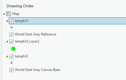
So this works great in that I'm getting a symbol plotted where I needed. But it does that three (3) times giving me the following output.
Now, I realize I could try and control the place of insertion by using addLayer() and using the LYRX file directly after updating its data source. But the above output is not what I would expect based on what I'm doing. What's going on there?
Solved! Go to Solution.
Accepted Solutions
- Mark as New
- Bookmark
- Subscribe
- Mute
- Subscribe to RSS Feed
- Permalink
Regarding these lines:
arcpy.management.ApplySymbologyFromLayer(feature_class,symbologyLayer)
# Interestingly, the following works too
#arcpy.ApplySymbologyFromLayer_management(feature_class,symbologyLayer)Line #01 and Line #04 call the exact same geoprocessing tool, so you should expect them to both work. Line #01 represents the new syntax that Esri is pushing with Pro while Line #04 represents the original/legacy syntax.
The default for arcpy.env.addOutputsToMap is True, and I am guessing you are using the defaults, so lines #10, #18, and #24 in your code snippet will all add layers to the TOC, which is what you are seeing.
- Mark as New
- Bookmark
- Subscribe
- Mute
- Subscribe to RSS Feed
- Permalink
C:\....Your_Install_path...\Resources\ArcPy\arcpy\management.py
arcpy.management.ApplySymbologyFromLayer.__esri_toolname__
'ApplySymbologyFromLayer_management'
arcpy.management.ApplySymbologyFromLayer.__module__
'arcpy.management'
# ---- same
arcpy.ApplySymbologyFromLayer_management.__esri_toolname__
'ApplySymbologyFromLayer_management'
arcpy.ApplySymbologyFromLayer_management.__module__
'arcpy.management'
# ---- and finally
arcpy.management.ApplySymbologyFromLayer.__code__
<code object ApplySymbologyFromLayer at 0x00000158E26CDA50, file
"C:\arc_pro\Resources\ArcPy\arcpy\management.py", line 8520>
Lots to explore in those folders, especially the new toolbox structure
C:\....Your_Install_path...\Resources\ArcToolBox\toolboxes\Data Management Tools.tbx\ApplySymbologyFromLayer.tool
... sort of retired...
- Mark as New
- Bookmark
- Subscribe
- Mute
- Subscribe to RSS Feed
- Permalink
Good stuff, Dan. This wasn't the first time I got close to sifting through those folders. But I'll be back to the JSAPI tomorrow, so I'm doomed to a life of limited understahding!
- Mark as New
- Bookmark
- Subscribe
- Mute
- Subscribe to RSS Feed
- Permalink
I was beginning to wonder something like this... whether some "actions" are implied. Glad you bring
arcpy.env.addOutputsToMap
to my attention. Will take a look. Thanks!
- Mark as New
- Bookmark
- Subscribe
- Mute
- Subscribe to RSS Feed
- Permalink
On second though, this might explain why the behavior is even different as part of a geoprocessing service... maybe server Python/arcpy has different environmental settings by defaul? I will have to look at that, too.