- Home
- :
- All Communities
- :
- Developers
- :
- Python
- :
- Python Questions
- :
- Re: How can get the actual Cell Size form "Analysi...
- Subscribe to RSS Feed
- Mark Topic as New
- Mark Topic as Read
- Float this Topic for Current User
- Bookmark
- Subscribe
- Mute
- Printer Friendly Page
How can get the actual Cell Size form "Analysis Cell Size" parameter
- Mark as New
- Bookmark
- Subscribe
- Mute
- Subscribe to RSS Feed
- Permalink
I am trying to build a Python Toolbox. I need to get the cell size using the following code snippet. Using this parameter you can directly enter the cell size as a number or pick a GIS layer to let the ArcPy to calculate the cell size (If the layer is raster, it will be same as the raster's cell size, otherwise it will be the minimum extent /250).
It is working well and I can use the defined parameter (cell_Size) as Cellsize in any tool (i.e. "Point to Raster"). In my program I need the cell size value (as number) however when you use "cell_Size.valueAsText", you get just the root of the layer as string!
I need the property that I can get the calculated cell size by ArcPy. I tried "cell_Size.Cellsize" , "cell_Size.size" etc. but they are not working.
    # First parameter
    cell_Size = arcpy.Parameter(
    displayName = "Cell Size",
    name = "cell_Size",
    datatype = "Analysis Cell Size",
    parameterType="Required",
    direction="Input ")
Solved! Go to Solution.
- Mark as New
- Bookmark
- Subscribe
- Mute
- Subscribe to RSS Feed
- Permalink
Actually, I have seen this type of behavior. It is possible to select a featureclass to determine the cellsize. Not in the geoprocessing environment, but in other parts.
Maybe you could try something like:
def GetCellSize(user_cell_size):
try:
# parse to double
cell_size = float(user_cell_size)
except:
# not a numeric value
desc = arcpy.Describe(user_cell_size)
if hasattr(desc, "datasetType"):
if desc.datasetType == 'FeatureClass':
extent = desc.extent
max_size = max(extent.width, extent.height)
cell_size = max_size / 250.0
elif desc.datasetType == 'RasterDataset':
raster = arcpy.Raster(user_cell_size)
cell_size = (raster.meanCellHeight + raster.meanCellWidth) / 2.0
else:
cell_size = None
return cell_size- Mark as New
- Bookmark
- Subscribe
- Mute
- Subscribe to RSS Feed
- Permalink
Thank you,
Do you know how can filter just Raster layers during the parameter definition as follows:
cell_Size = arcpy.Parameter(
displayName="Cell Size",
name="cell_Size",
datatype="Analysis Cell Size",
parameterType="Required",
direction="Input")
I tried
cell_Size.filter.list = ["Raster"]But it does not work
- Mark as New
- Bookmark
- Subscribe
- Mute
- Subscribe to RSS Feed
- Permalink
Have look at the datatypes listed here: Defining parameter data types in a Python toolbox—Geoprocessing and Python | ArcGIS Desktop
- Mark as New
- Bookmark
- Subscribe
- Mute
- Subscribe to RSS Feed
- Permalink
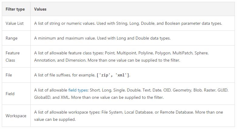
Right know, I found out that we can not use the "Raster" as filter. It is really weird!
Take a look at the following table:
- Mark as New
- Bookmark
- Subscribe
- Mute
- Subscribe to RSS Feed
- Permalink
So, it's not possible to use "DERasterDataset", like in the example mentioned here: Defining parameter data types in a Python toolbox—Geoprocessing and Python | ArcGIS Desktop
- Mark as New
- Bookmark
- Subscribe
- Mute
- Subscribe to RSS Feed
- Permalink
Yes, however, when you are developing a python toolbox and using "Analysis Cell Size" parameter to get the cell size, it shows you every thing!
- Mark as New
- Bookmark
- Subscribe
- Mute
- Subscribe to RSS Feed
- Permalink
If you set the cell size environment to the result of valueAsText and the parameter is a raster path, the value set will be the raster's meanCellHeight (as string).
>>> from arcpy import env
>>> env.cellSize = "copy_ras"
>>> env.cellSize
u'10'If the user does not select a dataset but instead leaves it at Maximum of Inputs, etc. will be a number or a string "MAXOF", "MINOF", etc.
arcpy.env.cellSize = cell_Size.valueAsText
try:
cell_Size = float(env.cellSize)
except:
arcpy.AddError("Cell size not numeric: {}".format(cell_Size))You could do this test in the parameter validation if you wanted to trap it before the tool runs.
Another approach I have used is to define my cell size parameter as Double and used parameter validation to have it default to the environment cell size (if set).
- Mark as New
- Bookmark
- Subscribe
- Mute
- Subscribe to RSS Feed
- Permalink
Yes, After few days struggling, finally, I used Double as cell size.
- Mark as New
- Bookmark
- Subscribe
- Mute
- Subscribe to RSS Feed
- Permalink
mrnikfal If this was your solution, please mark my answer as correct so others can find it, thanks.
- Mark as New
- Bookmark
- Subscribe
- Mute
- Subscribe to RSS Feed
- Permalink
double/float.... as a parameter, see the first post
- « Previous
-
- 1
- 2
- Next »
- « Previous
-
- 1
- 2
- Next »