- Home
- :
- All Communities
- :
- Developers
- :
- Python
- :
- Python Questions
- :
- Re: create line-chord from higher point to lower
- Subscribe to RSS Feed
- Mark Topic as New
- Mark Topic as Read
- Float this Topic for Current User
- Bookmark
- Subscribe
- Mute
- Printer Friendly Page
- Mark as New
- Bookmark
- Subscribe
- Mute
- Subscribe to RSS Feed
- Permalink
1). Hello i want to create 2 species of line. The first i created it with straight segment form editing tools, as for the second i want it to have the same start and end point but to be drawn as a chord on the terrain, and not on the surface of it, to calculate the difference of their heights.Any help? Should i use traverse editing tool for that?
Solved! Go to Solution.
Accepted Solutions
- Mark as New
- Bookmark
- Subscribe
- Mute
- Subscribe to RSS Feed
- Permalink
You can use this code:
import arcpy

fc_in = r"C:\Forum\test.gdb\Polyline_chord"
fc_out = r"C:\Forum\test.gdb\Polyline_straight"

sr = arcpy.Describe(fc_in).spatialReference

lines = []
with arcpy.da.SearchCursor(fc_in, ("SHAPE@")) as curs:
    for row in curs:
        polyline_in = row[0]
        polyline_out = arcpy.Polyline(arcpy.Array([polyline_in.firstPoint, polyline_in.lastPoint]), sr)
        lines.append(polyline_out)

    arcpy.CopyFeatures_management(lines, fc_out)
Kind regards, Xander
- Mark as New
- Bookmark
- Subscribe
- Mute
- Subscribe to RSS Feed
- Permalink
Can you explain what exactly it is you mean by "chord"? If you have a picture to explain what you are after that would be helpful too.
- Mark as New
- Bookmark
- Subscribe
- Mute
- Subscribe to RSS Feed
- Permalink
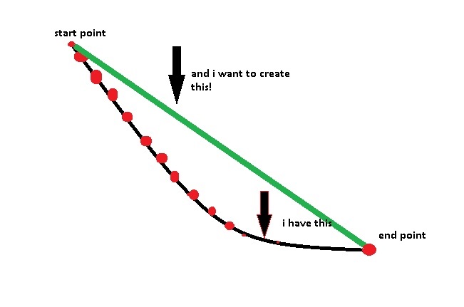
i want to create the green line which will be precisly above the black line, because i want to calculate the differences at their altitudes at the points with red colour
- Mark as New
- Bookmark
- Subscribe
- Mute
- Subscribe to RSS Feed
- Permalink
You can use this code:
import arcpy

fc_in = r"C:\Forum\test.gdb\Polyline_chord"
fc_out = r"C:\Forum\test.gdb\Polyline_straight"

sr = arcpy.Describe(fc_in).spatialReference

lines = []
with arcpy.da.SearchCursor(fc_in, ("SHAPE@")) as curs:
    for row in curs:
        polyline_in = row[0]
        polyline_out = arcpy.Polyline(arcpy.Array([polyline_in.firstPoint, polyline_in.lastPoint]), sr)
        lines.append(polyline_out)

    arcpy.CopyFeatures_management(lines, fc_out)
Kind regards, Xander