- Home
- :
- All Communities
- :
- Industries
- :
- Public Safety
- :
- Public Safety Blog
- :
- FirstNet's App Challenge Meets Esri Web Apps
FirstNet's App Challenge Meets Esri Web Apps
- Subscribe to RSS Feed
- Mark as New
- Mark as Read
- Bookmark
- Subscribe
- Printer Friendly Page
By Mike King, Industry Manager, CAD/Law Enforcement, Esri
Hundreds of technology and government professionals gathered at the APCO Public Safety Broadband Summit in Washington, DC, in May 2017. A great deal of attention was focused on the keynote address by FirstNet CEO Michael Poth, and the audience showed much interest in the organization's preparations for nationwide broadband deployment.
Following Poth, Mark Golaszewski, FirstNet director of applications, revealed a number of goals for application development including a strategy to have apps that enable users in public safety to adopt and leverage the technologies of the commercial marketplace, a vision to propagate innovation, and an ecosystem that allows FirstNet and the commercial community to offer the best available tools and technologies available.
Golaszewski declared that these "high-priority" applications needed to include GIS mapping and the ability to visualize large volumes of data with the Internet of Things (IoT). The apps should be able to synthesize actionable information in operational viewers and include information such as computer-aided dispatch (CAD) data, vehicle locations, and other sensor data in a connected or unconnected, secure environment.
Esri had an opportunity to offer our GIS strategy for Next Generation 911 (NG911) immediately following the FirstNet presentation, and we took advantage of the timing to show how we are answering the FirstNet challenge with out-of-the-box web applications, tools, and templates. Since most government agencies are using Esri for their geospatial responsibilities, taking advantage of these free tools (for license holders) makes good fiscal sense, and those in attendance were counseled to speak with their jurisdictional GIS staff to see what licensing was available already.
The remainder of this blog will focus on a few of those FirstNet challenges, with examples of how Esri's web applications are answering the call, sometimes in a matter of hours.
Situational Awareness—Esri's out-of-the-box templates provide powerful ways to visualize data from a host of services: agencies' own internal data services, enterprise GIS, demographics, other sensor data feeds, and information in formats as simple as spreadsheets stored on a computer's desktop.
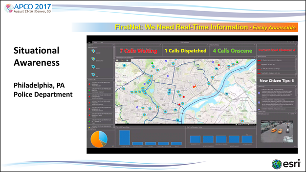
This example—calls for service from the Philadelphia, Pennsylvania, Police Department—was built in a day using Esri's Operations Dashboard for ArcGIS (a free template for license holders.) The dashboard shows a number of important things. In the upper left corner, we see Waze data being visualized on 1 of 12 maps that include street data, aerial imagery, and topography. Across the top is the current CAD queue, and in the middle of the left side, we see current CAD calls for service. Customizable metrics are displayed across the bottom of the screen, with video from 1 of 939 cameras appearing in the lower right corner. Above the closed circuit television (CCTV) image, in the center, is the Citizen Tips section, and above that is a report of all road closures in the city.
Operational dashboards like this are available to download for free and configure if you are an Esri license holder and can consume data hosted on-premises, in the cloud, on a desktop, or through a hybrid approach.
Portable Reporting with Credentialing—Esri provides tools for agencies to easily develop web applications for use in the field on iOS, Android, and Windows devices. These mobile apps enable data collection and allow greater collaboration among agencies, leading to increased understanding. The example below shows how one agency used ArcGIS out of the box to develop a tool for intelligence gathering in a serial killer investigation.

Information Synthesis—Analyzing large volumes of data is difficult. As we embrace the challenge to visualize and analyze larger datasets, including sensor data found through the IoT, the need for tools and technologies that handle big data becomes more critical. Insights for ArcGIS makes the exploration, analysis, and iteration of such data easier than ever with its drag-and-drop capabilities, the infusion of demographic data, and guided workflows. Now big data doesn't seem so big. This example shows billions of financial records being analyzed. At Esri, we say, "Rather than look for a needle in a haystack, simply burn down the haystack, pick up the needle, and move on to the next question."

Analyzing and Interpreting Sensor Data—As the IoT continues to bloom, more data is becoming available each day. By using an enterprise GIS, public safety professionals can begin to examine and understand how one type of data interacts with or influences another. This example shows Waze data in Budapest, Hungary, and examines the reliability of Waze against other public media surrounding major events.

Embracing NG911 Data—As more information becomes available through NG911, public safety professionals will need the ability to consume and analyze the data, sometimes on the fly. Enterprise GIS enables users to do just that, and challenges like 3D and indoor routing are surmountable now.
Esri is pleased to support the first responders who will rely on FirstNet, and we will continue to invest in research and development to assist the first responder community. For more information on the tools and templates available through Esri, visit esri.com/industries/public-safety and resources.arcgis.com/en/home/
You must be a registered user to add a comment. If you've already registered, sign in. Otherwise, register and sign in.