Runtime Team,
(Using Esri.ArcGISRuntime 100.6/WPF)
I have an application where I'm showing various assets (vehicles, people, etc) moving around a map. To accomplish this, I'm using a GraphicsOverlay with a UniqueValueRenderer. Everything seems to be working well, except when I'm zoomed in on an asset (zoom level doesn't seem to make a difference), the defined label is not always moving along with the symbol. This seems that it may have something to do with label weights, and the label waiting to be in an area where it has enough room to render. I need this label to always be moving along with the graphic, even if it is showing up on top of other labels defined in the map, I'm guessing this may be something I'm missing in the label definition?
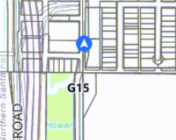
See in the image how the label G15 is significantly behind the symbol. Eventually, it will seemingly randomly catch up to it.
StringBuilder gphLabelsBuilder <SPAN class="operator token">=</SPAN> <SPAN class="keyword token">new</SPAN> <SPAN class="token class-name">StringBuilder</SPAN><SPAN class="punctuation token">(</SPAN><SPAN class="punctuation token">)</SPAN><SPAN class="punctuation token">;</SPAN>
gphLabelsBuilder<SPAN class="punctuation token">.</SPAN><SPAN class="token function">AppendLine</SPAN><SPAN class="punctuation token">(</SPAN><SPAN class="string token">"{"</SPAN><SPAN class="punctuation token">)</SPAN><SPAN class="punctuation token">;</SPAN>
<SPAN class="comment token">// Define a labeling expression that will show the unit attribute value</SPAN>
gphLabelsBuilder<SPAN class="punctuation token">.</SPAN><SPAN class="token function">AppendLine</SPAN><SPAN class="punctuation token">(</SPAN><SPAN class="string token">"\"labelExpressionInfo\": {"</SPAN><SPAN class="punctuation token">)</SPAN><SPAN class="punctuation token">;</SPAN>
gphLabelsBuilder<SPAN class="punctuation token">.</SPAN><SPAN class="token function">AppendLine</SPAN><SPAN class="punctuation token">(</SPAN><SPAN class="string token">"\"expression\": \"return $feature.Header;\"},"</SPAN><SPAN class="punctuation token">)</SPAN><SPAN class="punctuation token">;</SPAN>
<SPAN class="comment token">// Align labels horizontally</SPAN>
gphLabelsBuilder<SPAN class="punctuation token">.</SPAN><SPAN class="token function">AppendLine</SPAN><SPAN class="punctuation token">(</SPAN><SPAN class="string token">"\"labelPlacement\": \"esriServerPointLabelPlacementAboveCenter\","</SPAN><SPAN class="punctuation token">)</SPAN><SPAN class="punctuation token">;</SPAN>
<SPAN class="comment token">// Use a green bold text symbol</SPAN>
gphLabelsBuilder<SPAN class="punctuation token">.</SPAN><SPAN class="token function">AppendLine</SPAN><SPAN class="punctuation token">(</SPAN><SPAN class="string token">"\"symbol\": {"</SPAN><SPAN class="punctuation token">)</SPAN><SPAN class="punctuation token">;</SPAN>
gphLabelsBuilder<SPAN class="punctuation token">.</SPAN><SPAN class="token function">AppendLine</SPAN><SPAN class="punctuation token">(</SPAN><SPAN class="string token">"\"color\": [0,0,0,255],"</SPAN><SPAN class="punctuation token">)</SPAN><SPAN class="punctuation token">;</SPAN>
gphLabelsBuilder<SPAN class="punctuation token">.</SPAN><SPAN class="token function">AppendLine</SPAN><SPAN class="punctuation token">(</SPAN><SPAN class="string token">"\"font\": {\"size\": 10, \"weight\": \"bold\"},"</SPAN><SPAN class="punctuation token">)</SPAN><SPAN class="punctuation token">;</SPAN>
gphLabelsBuilder<SPAN class="punctuation token">.</SPAN><SPAN class="token function">AppendLine</SPAN><SPAN class="punctuation token">(</SPAN><SPAN class="string token">"\"haloColor\": [255,255,255,255],"</SPAN><SPAN class="punctuation token">)</SPAN><SPAN class="punctuation token">;</SPAN>
gphLabelsBuilder<SPAN class="punctuation token">.</SPAN><SPAN class="token function">AppendLine</SPAN><SPAN class="punctuation token">(</SPAN><SPAN class="string token">"\"haloSize\": 1,"</SPAN><SPAN class="punctuation token">)</SPAN><SPAN class="punctuation token">;</SPAN>
gphLabelsBuilder<SPAN class="punctuation token">.</SPAN><SPAN class="token function">AppendLine</SPAN><SPAN class="punctuation token">(</SPAN><SPAN class="string token">"\"type\": \"esriTS\"}"</SPAN><SPAN class="punctuation token">)</SPAN><SPAN class="punctuation token">;</SPAN>
gphLabelsBuilder<SPAN class="punctuation token">.</SPAN><SPAN class="token function">AppendLine</SPAN><SPAN class="punctuation token">(</SPAN><SPAN class="string token">"}"</SPAN><SPAN class="punctuation token">)</SPAN><SPAN class="punctuation token">;</SPAN>
GraphicOverlay<SPAN class="punctuation token">.</SPAN>LabelsEnabled <SPAN class="operator token">=</SPAN> <SPAN class="keyword token">true</SPAN><SPAN class="punctuation token">;</SPAN>
GraphicOverlay<SPAN class="punctuation token">.</SPAN>LabelDefinitions<SPAN class="punctuation token">.</SPAN><SPAN class="token function">Add</SPAN><SPAN class="punctuation token">(</SPAN>LabelDefinition<SPAN class="punctuation token">.</SPAN><SPAN class="token function">FromJson</SPAN><SPAN class="punctuation token">(</SPAN>gphLabelsBuilder<SPAN class="punctuation token">.</SPAN><SPAN class="token function">ToString</SPAN><SPAN class="punctuation token">(</SPAN><SPAN class="punctuation token">)</SPAN><SPAN class="punctuation token">)</SPAN><SPAN class="punctuation token">)</SPAN><SPAN class="punctuation token">;</SPAN><SPAN class="line-numbers-rows"><SPAN></SPAN><SPAN></SPAN><SPAN></SPAN><SPAN></SPAN><SPAN></SPAN><SPAN></SPAN><SPAN></SPAN><SPAN></SPAN><SPAN></SPAN><SPAN></SPAN><SPAN></SPAN><SPAN></SPAN><SPAN></SPAN><SPAN></SPAN><SPAN></SPAN><SPAN></SPAN><SPAN></SPAN></SPAN> This is how the label is being defined, the GraphicOverlay object is of type GraphicsOverlay with the rendering mode dynamic.
Hopefully an obvious property I'm missing in the label definition JSON?
EDIT: If it matters, I'm updating the graphic location by grabbing the Graphic from the GraphicsOverlay by its unique identifier (FirstOrDefault with Label), and setting the Geometry property to a new MapPoint created with the new coordinates.
Furthermore, I would like to ask if this is the best practice for displaying rapidly changing data on a map? All examples I've been able to find on anything relatively close to this use case seem to use GraphicsOverlays/Symbols, but I wanted to see if there's a known better practice.

