- Home
- :
- All Communities
- :
- Products
- :
- ModelBuilder
- :
- ModelBuilder Questions
- :
- Re: Calculate and use extent of feature class in m...
- Subscribe to RSS Feed
- Mark Topic as New
- Mark Topic as Read
- Float this Topic for Current User
- Bookmark
- Subscribe
- Mute
- Printer Friendly Page
Calculate and use extent of feature class in model builder for geoprocessing task
- Mark as New
- Bookmark
- Subscribe
- Mute
- Subscribe to RSS Feed
- Permalink
Hello
I have a series of models. One of the models creates/overwrites a feature class based on a user selection of features. A second tool is trying to run an 'Union' tool using the extents of the feature class mentioned. Initially I had extents of feature class as an environment input into Union in my model, however, I found that I have to revalidate the model every time before I run, otherwise it just uses the same extents coordinates.
I tried using the 'Calculate Value' saving value as 'Extent' object to recalculate the extent and use that everytime, but it doesnt work. It runs without errors but does not appear to use the extents Im trying to pass through. Ive tried several syntax options but none work.
Any ideas on how to do this? Below is very simple model

Solved! Go to Solution.
Accepted Solutions
- Mark as New
- Bookmark
- Subscribe
- Mute
- Subscribe to RSS Feed
- Permalink
(I realize this is a somewhat old question, but having just run into the issue today, I wanted to make sure there's a googleable answer for the next time it stymies me!)
This is a weird one, and the esri documentation is uncharacteristically unhelpful. Here's what I found that worked...
Basically, the function needs to return a string, not an extent object; the output type is being set to enable you to chain items in ModelBuilder but isn't actually relevant to the value you return! What worked for me was to return a string in the format "xmin ymin xmax ymax" and set the output type to Extent. Arcpy/ModelBuilder are smart enough to know from the output type that you should be able to use the output of your function as input to an Extent parameter of another tool, and are also smart enough to handle the coercion from the string formatting of the extent to the expected Extent object.

- Mark as New
- Bookmark
- Subscribe
- Mute
- Subscribe to RSS Feed
- Permalink
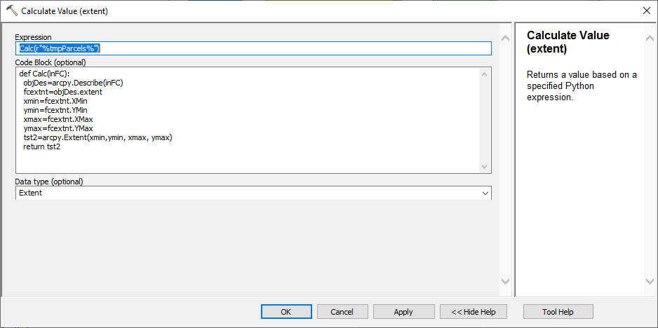
Those extent objects can be a bit tricky, I might amend it to something like:
#create a copy of extent object to modify
new_extent = objDes.extent
#set values for extent object
new_extent.XMin = objDes.extent.XMin
new_extent.XMax = objDes.extent.XMax
new_extent.YMin = objDes.extent.YMin
new_extent.YMax = objDes.extent.YMax
return new_extent
No idea if that will work as I struggle with these also. You may just want to run the 'Feature envelope to polygon' tool on the data then use that polygon as the extent if not.
- Mark as New
- Bookmark
- Subscribe
- Mute
- Subscribe to RSS Feed
- Permalink
Hi David - thanks for the suggestion, but unfortunately trying to set the values didnt seem to work either. Ill look into the envelope option - that sounds promising.
Thanks again
- Mark as New
- Bookmark
- Subscribe
- Mute
- Subscribe to RSS Feed
- Permalink
(I realize this is a somewhat old question, but having just run into the issue today, I wanted to make sure there's a googleable answer for the next time it stymies me!)
This is a weird one, and the esri documentation is uncharacteristically unhelpful. Here's what I found that worked...
Basically, the function needs to return a string, not an extent object; the output type is being set to enable you to chain items in ModelBuilder but isn't actually relevant to the value you return! What worked for me was to return a string in the format "xmin ymin xmax ymax" and set the output type to Extent. Arcpy/ModelBuilder are smart enough to know from the output type that you should be able to use the output of your function as input to an Extent parameter of another tool, and are also smart enough to handle the coercion from the string formatting of the extent to the expected Extent object.
- Mark as New
- Bookmark
- Subscribe
- Mute
- Subscribe to RSS Feed
- Permalink
This worked great! Thank you for posting Jeffrey.
- Mark as New
- Bookmark
- Subscribe
- Mute
- Subscribe to RSS Feed
- Permalink
Thanks for this workaround! Create Fishnet and Grid Index Features both have this same problem in ModelBuilder. It would be nice if the input extent text auto-populated when running the model like it does when you run the standalone tool. It seems silly to need a multiple-line Python script just to pass on the extent of a feature class to a tool, but I haven't found a better way.
- Mark as New
- Bookmark
- Subscribe
- Mute
- Subscribe to RSS Feed
- Permalink
I am trying to get the extension using this post.
From a Feature Set that the user will populate (add a colon) and use as an extension to get a slope smaller in size.


The problem is that I only get the extension of the first point when I use the Feature set (append). And not the extension of the two generated points; so the cut extension of the slope raster is smaller than the one I am interested in.

Can you find the reason why? Thank you
- Mark as New
- Bookmark
- Subscribe
- Mute
- Subscribe to RSS Feed
- Permalink
Your cursor is capturing the shape of the first point. I believe that if you want the extent of the union of both points, you want to get the extent from arcpy.Describe() on the feature set.