- Home
- :
- All Communities
- :
- Products
- :
- Mapping
- :
- Mapping Questions
- :
- Re: Help analyzing a map
- Subscribe to RSS Feed
- Mark Topic as New
- Mark Topic as Read
- Float this Topic for Current User
- Bookmark
- Subscribe
- Mute
- Printer Friendly Page
Help analyzing a map
- Mark as New
- Bookmark
- Subscribe
- Mute
- Subscribe to RSS Feed
- Permalink
So, I'm looking to build maps for personal use using ArcMap 10.1. These would be used as trail maps to navigate local trail systems. I want to base my map's style off another I've found online. I'm looking for help breaking down that found map. It's posted below.
Note - I'm searching for help deducing the layers, and their type, not the title, legend, pictures, compass, and description
What what I see in terms of layers includes:
1. Raster - topographic. Is there style name for this sort of topographic map (contour lines and elevation divided by color).
2. GPS Data of trails
3. Civil Boundries
4. Hydrology
I think the most impressive part of this map is the raster data. Any suggestions on where I could find such data for upstate New York with high enough resolution to have the maps printed.
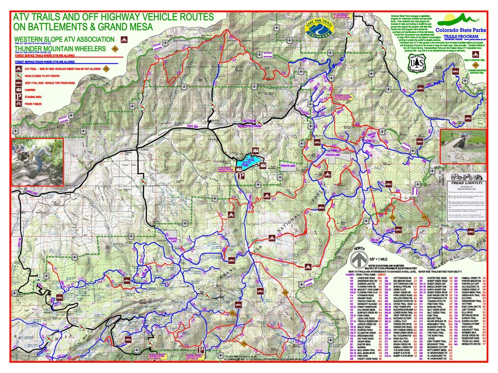
Thanks to the guys at Colorado State Park Trail Program for building this great map!
- Mark as New
- Bookmark
- Subscribe
- Mute
- Subscribe to RSS Feed
- Permalink
Raster: Your raw elevation data could be from files in many formats, or even in a different data model--vector. Think of a TIN (triangulated irregular network) surface. But often they are called DEMs (Digital elevation models) and are in a raster formats. This surface looks like it has a color ramp applied to it--changing from green to white/light gray with elevation. Then off this you have contours (lines of constant elevation) generated and also a hillshade (this is the part that makes it look 3D by making shadows on the surface as if cast by the sun).
Vector: You have polygon data (most likely) for your park boundaries, lakes, etc. Polylines for your roads, streams, and paths. And lastly, Points for your camp sites, picnic tables, etc.
I would look for the elevation data on you state government's web pages and then I would look at the USGS data.
For the vector: I would look at the state's data and maybe the park's. Often organizations have some sort of GIS data portal or clearinghouse. New York is a big state they are sure to have something.
Okay, hope that gets you started.
- Mark as New
- Bookmark
- Subscribe
- Mute
- Subscribe to RSS Feed
- Permalink
Hi Daniel,
Are you familiar with this site for hydrography data?
- Mark as New
- Bookmark
- Subscribe
- Mute
- Subscribe to RSS Feed
- Permalink
Marcus - thank you! Have you noticed any of my other posts?
This site is really great - it's almost what exactly what I'm looking for. The ability to set the orthoimagery parameters the subsequently download the corresponding data is really easy and fast! I don't know if other mapping tools have this option,I have never noticed it before, but it's a great feature.Thank you!
I downloaded so of the topo data to play around with. It came in geopdf filestype, (only available option for topo data). I'll next have to figure out how to convert geopdf into a form that's legible to ArcMap 10.1.
- Mark as New
- Bookmark
- Subscribe
- Mute
- Subscribe to RSS Feed
- Permalink
Daniel, I am glad you might be able to make some use of the USGS site that I mentioned. Actually the part that I thought might be the most immediately useful for you was the hydrography vector data. I am including an image of a quick map I put together using only a single 3 meter DEM raster and the USGS hydrography vector data.
I created hillshade and contours using the Surface toolbox in the Spatial Analyst toolset (ArcMap 10.1). I applied standard elevation color ramp symbology to the DEM layer, made it partially transparent, and placed it over the hillshade layer. Then I placed the vector layers (hillshade and hydrography) on top of that. Its pretty rough, but may give an idea of some of the potential of DEM data for your purposes. It should allow for a lot more customization than using a pre-made topo basemap.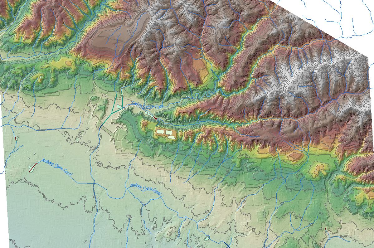
- Mark as New
- Bookmark
- Subscribe
- Mute
- Subscribe to RSS Feed
- Permalink
Thank you for the hep breaking down the map Forest, and for the quick vocab lesson on GIS. I'm learning a lot here on this forum.
DEM seems to come standard in black and white, but building in a color ramp seems intuitively easy if there is associated elevation change data. Is it the case that DEMs generally come with associated elevation change data useful to change the color ramp from black/white to green/white? I'll check the NYS Clearinghouse website for DEM data (I don't think triangulated irregular network data is what I'm looking for), if I can't find it there I will check the US Geological Survay website for data.
I will have to ask others about whether contour lines can be built in using a ArcMap function, or does one have to acquire a datalayer for contour data.
- Mark as New
- Bookmark
- Subscribe
- Mute
- Subscribe to RSS Feed
- Permalink
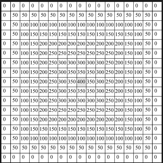
Yes, you do not want a TIN, I was just trying to point out that elevation data does not have to be in a raster. And yes all DEMs will have elevation data in them. Think of a black and white digital image that you would take with your camera. Each pixel has a value that repentants how much light the sensor detected. So, in a DEM each pixel has a value, but instead of it being a measurement of reflected light it is a measurement of elevation.
Extra 001 - An Exercise in Digital Elevation/Terrain Models
And yes one can make coutures with ArcGIS quickly. There are a few ways to do this in Arc, but bellow is one way.
http://resources.arcgis.com/EN/HELP/MAIN/10.1/index.html#//01030000001q000000
- Mark as New
- Bookmark
- Subscribe
- Mute
- Subscribe to RSS Feed
- Permalink
Daniel,
Don't forget to look for points of interest such as campgrounds and trail heads.
Your example map also has Mountain range names and major rds.
- Mark as New
- Bookmark
- Subscribe
- Mute
- Subscribe to RSS Feed
- Permalink
The particular map that shows the topography are historic USGS Topo Maps, you should be able to download them in your area of interest and clip them to the boundary you need.
See:
USGS Historical Topographic Maps | topoView
Luckily these are available as GeoTIFF, as well as GeoPDF, so much easier to handle in ArcMap
Now that map also seems to have a hillshading beneath it to help enhance the look of the elevation data, there are some online layers for hillshade, but you will likely want to download your own and clip to a custom extent. You should be able to find that, and many other vector layers here
- Mark as New
- Bookmark
- Subscribe
- Mute
- Subscribe to RSS Feed
- Permalink
Great this is great news, thanks for the detail. I will look into these for my map. I'm thinking that I'll try shooting for DEM data, but I'm thinking that my computer will have a hard time processing the data - and that historic USGS Topo Maps may be the better option given disc space.
What does it mean to "clip" a historic USGS topo map? Do you mean to assign long/lat coordinate systems to the corners while over a baselayer?