- Home
- :
- All Communities
- :
- Industries
- :
- Land Records and Valuation
- :
- Land Records and Valuation Questions
- :
- Re: Bad COGO?
- Subscribe to RSS Feed
- Mark Topic as New
- Mark Topic as Read
- Float this Topic for Current User
- Bookmark
- Subscribe
- Mute
- Printer Friendly Page
- Mark as New
- Bookmark
- Subscribe
- Mute
- Subscribe to RSS Feed
- Permalink
Hello,
I've been watching the Land Records Meetup videos and they have been a great help so far in helping me migrate our data to a LGIM parcel fabric. Bad COGO values are mentioned several times and it's recommended that they be removed, but are they talking about just the distances (which I understand) or the distances and the angles?
Thanks!
Solved! Go to Solution.
Accepted Solutions
- Mark as New
- Bookmark
- Subscribe
- Mute
- Subscribe to RSS Feed
- Permalink
Anna,
Bad COGO values refer to both bearings and distances. What you describe does not happen directly within the parcel fabric editing environment, but it could happen in older legacy systems. Then when importing that data from those systems into the fabric, those "mismatch" values get imported into the parcel fabric. This will result in parcels with a poor parcel misclose.
The Parcel Fabric Quality Control add-in can help to find these cases and, optionally, recalculate the values based on a filter that you set up.
-Tim
- Mark as New
- Bookmark
- Subscribe
- Mute
- Subscribe to RSS Feed
- Permalink
How do you determine what a bad COGO value is? That seems like it would be a good amount of analysis work in itself.
- Mark as New
- Bookmark
- Subscribe
- Mute
- Subscribe to RSS Feed
- Permalink
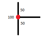
The example given in the video is the "back lot problem". A line that was originally drawn in as 100 feet is now broken into two 50 foot sections by an adjoining lot. Kind of like this:
The original line would still have 100 in the distance field and that can throw off the measurement tools in the parcel fabric, as far as I can tell from the videos. I don't have any experience with them yet 😕
- Mark as New
- Bookmark
- Subscribe
- Mute
- Subscribe to RSS Feed
- Permalink
Anna,
Bad COGO values refer to both bearings and distances. What you describe does not happen directly within the parcel fabric editing environment, but it could happen in older legacy systems. Then when importing that data from those systems into the fabric, those "mismatch" values get imported into the parcel fabric. This will result in parcels with a poor parcel misclose.
The Parcel Fabric Quality Control add-in can help to find these cases and, optionally, recalculate the values based on a filter that you set up.
-Tim