- Home
- :
- All Communities
- :
- Services
- :
- Implementing ArcGIS
- :
- Implementing ArcGIS Questions
- :
- Re: Minimum Bounding Geometry Irregular Polygon Le...
- Subscribe to RSS Feed
- Mark Topic as New
- Mark Topic as Read
- Float this Topic for Current User
- Bookmark
- Subscribe
- Mute
- Printer Friendly Page
Minimum Bounding Geometry Irregular Polygon Length & Width
- Mark as New
- Bookmark
- Subscribe
- Mute
- Subscribe to RSS Feed
- Permalink
Hi everyone,
First time poster. I am a student learning GIS and attempting to use it on a project I wish to pursue. It involves mapping many irregular polygon (couple of thousand). I need to be able to extract the length and width of the polygons to start with. I know I can get a length using geometry and then divide by 2 to get the average length.
I have been doing a lot of research online and have been attempting to use the bounding containers tool from data management. I am using ArcGIS 10.4 for Desktop. I am unsure though whether I am getting correct data from using the tool.
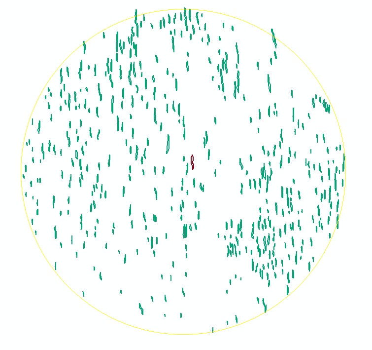
I opted to use rectangle by width, when I run it I only get intermittent data in the MGB Width field, either it has some data or is a zero. There are approximately 440 polygons in the first table. Attached are images of the polygons and a sample of the table output.
Any help would be greatly appreciated as I am now at my wits end. I just need to accurately get the length and width of the polygons. I will have to do it for varying numbers of polygons another 17 times.
Thanks
- Mark as New
- Bookmark
- Subscribe
- Mute
- Subscribe to RSS Feed
- Permalink
Your coordinates are in decimal degrees. It is best to use projected coordinate systems.
Try Bounding Containers with the Minimum, Area, bounding Rectangle option... If I remember, the axes lengths are calculated already. Limitation until I get it fixed is that shapefiles for input and output
- Mark as New
- Bookmark
- Subscribe
- Mute
- Subscribe to RSS Feed
- Permalink
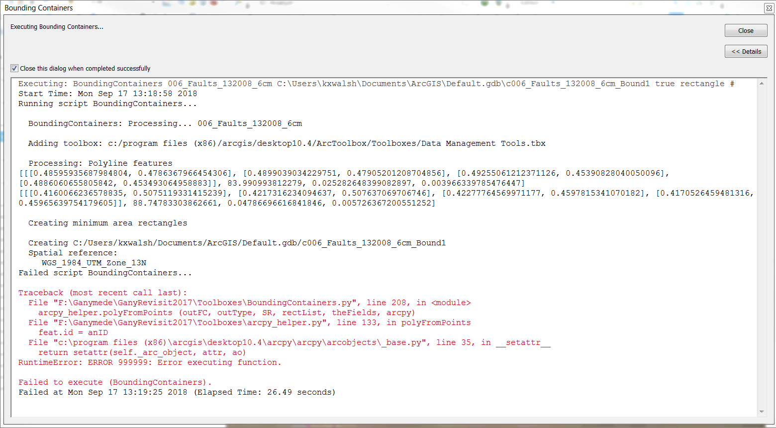
My geographic coordinate system is GCS_WGS_1984 and I use a Projected Coordinate System of WGS_1984_UTM_Zone_13N. I am using a shapefile overlaying a TIFF file to create the polygons. When I try and run the bounding containers on ArcMap 10.4 my dialog box does not have an option of minimum and area; it only has rectangle. I have attached a screenshot of the dialog box and then the error I received when I run the toolbox. I apologize but I have very little knowledge of GIS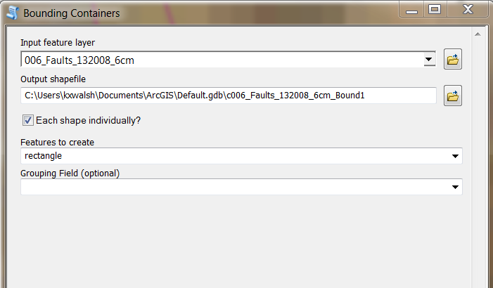
- Mark as New
- Bookmark
- Subscribe
- Mute
- Subscribe to RSS Feed
- Permalink
Your coordinates are in decimal degrees and you can't put a shapefile into a geodatabase as you have, it has to go into a folder (put a *.shp file extension on it)
- Mark as New
- Bookmark
- Subscribe
- Mute
- Subscribe to RSS Feed
- Permalink
Hi Mr Patterson, apologies for my late reply. I am using a shape file and folder, it was what I inherited. I am attaching an image of the type of polygon I am working with. Ideally, I would like to get a maximum width and a length for a mid-line down the center of the polygon. Is this possible in ArcGIS 10.4 desktop or even at all?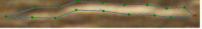
- Mark as New
- Bookmark
- Subscribe
- Mute
- Subscribe to RSS Feed
- Permalink
It seems to be over an image source.
How many of these polygons do you have to work with?
Are they all elongated like that? If so they might be a candidate for a Minimum Area Bounding Ellipse... which I have a toolbox for but only for ArcGIS Pro
- Mark as New
- Bookmark
- Subscribe
- Mute
- Subscribe to RSS Feed
- Permalink
Yes sir, I have a tiff with a shape-file overlain. On this particular shape-file there are approximately 1300 polygons; all generally oriented the same direction and usually long and narrow. I initially thought about an ellipse as being the best but obviously not an option in 10.4. Next I thought about using the Convex Hull but it doesn't return a width value for every polygon, see attached where some of the widths are zero. This is also the case if I use the rectangles. Only envelope returns a width for every polygon, however, that width is usually larger than the actual width.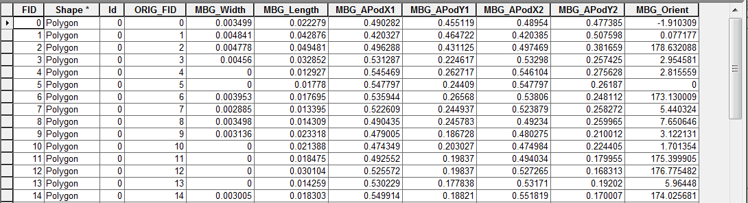
I am sure it is not an easily programmed solution. The number of vertices is not constant so trying to use x,y coordinates of each vertex to try and calculate the width is not trivial. I guess I will have to just use envelope. Rectangle by width would probably be the best fit but it also fails to return widths for some of the polygons.
- Mark as New
- Bookmark
- Subscribe
- Mute
- Subscribe to RSS Feed
- Permalink
Just as a side note, looking at the resulting MBG polygons, they do not in any way seem to be the logical result of the input polygons. The fact that they extent towards both side is very strange. Do you have data there? Are the polygon multipart by any way. Could you share a sample of your data to run some tests?

- Mark as New
- Bookmark
- Subscribe
- Mute
- Subscribe to RSS Feed
- Permalink
Hi Mr Bakker, what would you require? Would an export of an attribute table prior to running MBG be good?
- Mark as New
- Bookmark
- Subscribe
- Mute
- Subscribe to RSS Feed
- Permalink
Hi Ken Walsh , (it's just Xander please, Mr Bakker makes me feel sooo old) 😉
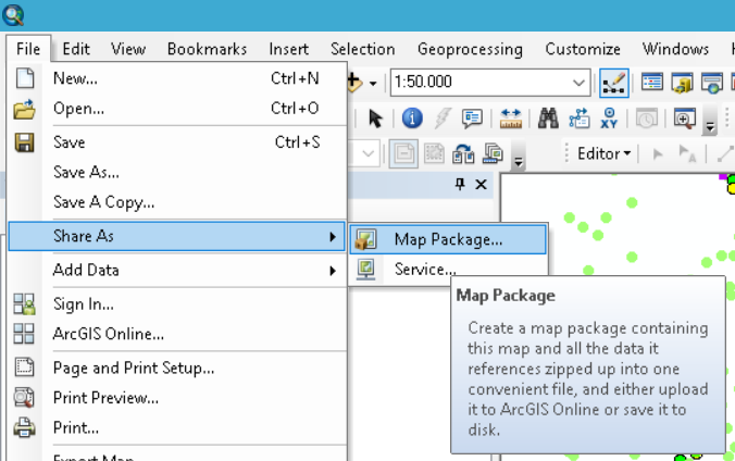
An export of the attributes would not include the geometry and the geometry is necessary to investigate what is happening. So you could select a couple of polygons that are representative for your data and export the selection to either a shapefile or featureclass inside a new file geodatabase or better, use the Share As, Map Package option with just a small set of your data in your ArcMap session (to avoid sharing all your data in case you don't want that):