- Home
- :
- All Communities
- :
- Services
- :
- Implementing ArcGIS
- :
- Implementing ArcGIS Questions
- :
- Re: 2 layers, points and polygons. If point is ins...
- Subscribe to RSS Feed
- Mark Topic as New
- Mark Topic as Read
- Float this Topic for Current User
- Bookmark
- Subscribe
- Mute
- Printer Friendly Page
2 layers, points and polygons. If point is inside the polygon, replace point layer with polygon?
- Mark as New
- Bookmark
- Subscribe
- Mute
- Subscribe to RSS Feed
- Permalink
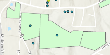
I have a shapefile that plots with points and another that plots parcels using polygons. I'm trying to figure out how to display the points as polygons, i.e. if the point is within the polygon, it creates a polygon and replaces the point. They are in two separate layers. Thanks!
Solved! Go to Solution.
Accepted Solutions
- Mark as New
- Bookmark
- Subscribe
- Mute
- Subscribe to RSS Feed
- Permalink
I would select by location where the point intersects the polygons, switch the selection then export the points as a new shapefile.
- Mark as New
- Bookmark
- Subscribe
- Mute
- Subscribe to RSS Feed
- Permalink
a shapefile or feature class can only be a point, line or polygon, not a combination of them.
- Mark as New
- Bookmark
- Subscribe
- Mute
- Subscribe to RSS Feed
- Permalink
Thanks for the reply David. Is there another way to convert the point shapefile to a polygon shapefile?
- Mark as New
- Bookmark
- Subscribe
- Mute
- Subscribe to RSS Feed
- Permalink
are you in pro, arcmap or agol?
you could buffer the points into a circle, or then turn that into another shape etc. but it really depends what you need to achieve.
- Mark as New
- Bookmark
- Subscribe
- Mute
- Subscribe to RSS Feed
- Permalink
I'm in Pro.
I've pasted an image below to clarify. I've turned the two layers on. What I want is to assign the polygon surrounding the point to replace the point in the layer containing the points. The end goal is when I select the layer which used to contain points, it displays the parcel polygon instead.

- Mark as New
- Bookmark
- Subscribe
- Mute
- Subscribe to RSS Feed
- Permalink
I would select by location where the point intersects the polygons, switch the selection then export the points as a new shapefile.
- Mark as New
- Bookmark
- Subscribe
- Mute
- Subscribe to RSS Feed
- Permalink
Thank you David!