- Home
- :
- All Communities
- :
- User Groups
- :
- GIS for Geology
- :
- Questions
- :
- Re: What is the recommended procedure on mapping f...
- Subscribe to RSS Feed
- Mark Topic as New
- Mark Topic as Read
- Float this Topic for Current User
- Bookmark
- Subscribe
- Mute
- Printer Friendly Page
What is the recommended procedure on mapping fractures in ArcGIS (ArcMap 10.2.2)?
- Mark as New
- Bookmark
- Subscribe
- Mute
- Subscribe to RSS Feed
- Permalink
I would like to map microfractures in a sample using ArcGIS.
Available Data: A micrograph of the sample under REM (BSE Mode) in a raster format (.jpeg). The contrast was set in a way that the fractures are easy to see. (Black lines over white grains). The raster is not projected, but the scale is known. How can I project the raster accordingly and set the scale?
Goal of the study: To calculate the number of fractures (approx.) and to construct a map of the space orientation of the fractures in order to get an indication of their source.
There seems to be no clear tutorials or literature discussing this method on the forums and discussion boards on the internet. So I hope I find my answer here. Could someone please guide me through the needed steps. I have basic knowledge of ArcGIS.
Thank you in advance and let's keep making the world a happier place
Hasso
- Mark as New
- Bookmark
- Subscribe
- Mute
- Subscribe to RSS Feed
- Permalink
Picture? see your other post for georeferencing comments. If you have <100, onscreen digitizing would be your quickest and best bet since the brain is better than any algorithm to perform that task.
- Mark as New
- Bookmark
- Subscribe
- Mute
- Subscribe to RSS Feed
- Permalink
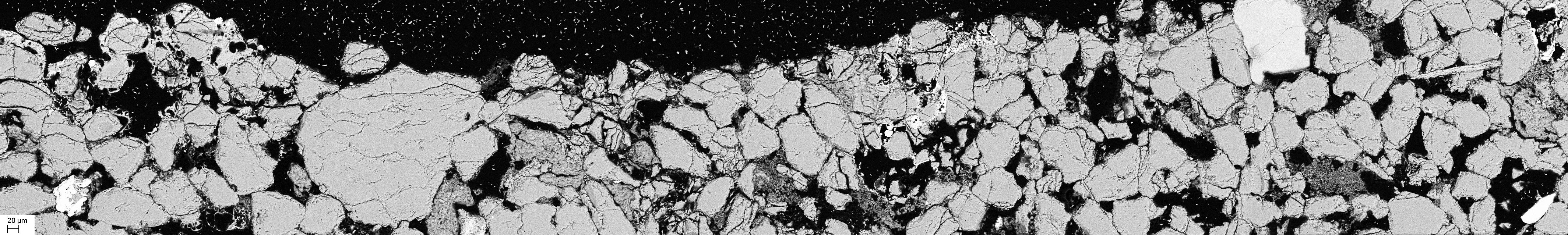
Hello Mr Patterson again and thank you for the support,
here is an example of the fractures I want to map.
- Mark as New
- Bookmark
- Subscribe
- Mute
- Subscribe to RSS Feed
- Permalink
Well if you are talking about the fractures on the bounding features, then you are going to have a problem. You have speckle in the large black areas, so any filtering is going to cause problems in the other areas.. As a start, you could try looking at filters to remove some of the background noise and enhance fractures...
http://desktop.arcgis.com/en/desktop/latest/tools/spatial-analyst-toolbox/how-filter-works.htm
- Mark as New
- Bookmark
- Subscribe
- Mute
- Subscribe to RSS Feed
- Permalink
Hello Mr. Patterson,
thank you again for taking the time to help me out. I will try to use filters to clean up the image. However, would it be perhaps possible to map these fractures manually using polylines? If so, how can I then analyze the overall orientation of the polylines?
Thank you in advance
- Mark as New
- Bookmark
- Subscribe
- Mute
- Subscribe to RSS Feed
- Permalink
Yes...just digitize them on-screen using the image as your basemap...most people try to avoid this and look for a solution to "automagically" do this for them 
- Mark as New
- Bookmark
- Subscribe
- Mute
- Subscribe to RSS Feed
- Permalink
Yes, it's of course much more time consuming to do it manually but I think I can manage. So once I have all my polylines how can I analyze their orientations and distribution? is there a tool for that? Also should I have all my polylines in one single shape file?
- Mark as New
- Bookmark
- Subscribe
- Mute
- Subscribe to RSS Feed
- Permalink
there is no one tool for that. I suggest that you open ArcToolbox and explore the functionality in the Data Management tools for a start... focus on those that allow you to determine/calculate the geometric properties of features. Once you have a handle on the information you can get using the basic tools, it may be necessary to write scripts to perform various tasks.
For example "orientation"
- from just the start and end points?
- a regression line fit to the polyline nodes?
- with respect to North? or the Cartesian axis?
- do all at once? or one at a time?
- do you want to cluster features since orientation of features could be spatially dependent?
etc
- Mark as New
- Bookmark
- Subscribe
- Mute
- Subscribe to RSS Feed
- Permalink
Alright, I'll look into it. But I just want to quantify the orientation with respect to North. So like saying for example 343 fractures have 10 angle and so on. Here is an example of how my plot should look like:
http://fas.org/irp/imint/docs/rst/Sect2/originals/Fig2_44.jpg
Thank you for your help, I'll dig into it.