- Home
- :
- All Communities
- :
- Products
- :
- Geoprocessing
- :
- Geoprocessing Questions
- :
- What causes contour lines in this Viewshed?
- Subscribe to RSS Feed
- Mark Topic as New
- Mark Topic as Read
- Float this Topic for Current User
- Bookmark
- Subscribe
- Mute
- Printer Friendly Page
- Mark as New
- Bookmark
- Subscribe
- Mute
- Subscribe to RSS Feed
- Permalink
- Report Inappropriate Content
I have produced a viewshed output here. What causes the (what appears to be) contour lines?
The raster surface was derived from 1m lidar data.
Can this be remedied? What would a good workaround be?
Edit: England
Solved! Go to Solution.
- Mark as New
- Bookmark
- Subscribe
- Mute
- Subscribe to RSS Feed
- Permalink
- Report Inappropriate Content
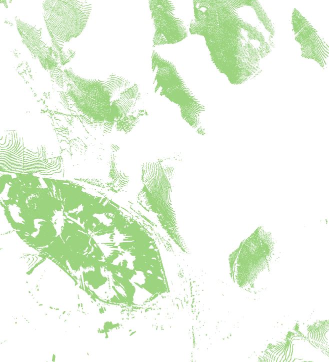
With the DEM data in your area of interest, the following are some of the experiments I did in order to see the source of the contouring effects.
1. With the original DEM at 2m resolution, I ran the Visibility tool and I can reproduce the contouring effects in the output (rendered using Orange color in below). The contouring effect in the Visibility output is due to the presence of terraces in the data, which is visible in the hillshade/elevation background.

2. After the DEM is resampled to 5m resolution using the Nearest Neighbor method, I ran the Visibility tool again and the new output based on the 5m resolution still has some contouring effects, as shown below:

3. After the DEM is resampled to 10m resolution using the Bilinear method, I ran the Visibility tool again and the new output based on the 10m resolution is free of contouring effects, as shown below:

4. With the original 2m DEM, I changed the observer height to 10 meters, and re-ran the Visibility tool. The new Visibility output (purple) is overlayed underneath the original Visibility output (orange) as follows. The new output (purple) contains less contouring effects:

5. With the original 2m DEM, I changed the observer height to 20 meters, and re-ran the Visibility tool. The new Visibility output (purple) is overlayed underneath the original Visibility output (orange) as follows. The new output (purple) contains even less contouring effects:

In summary,
(1) For the given DEM (2m with terrace like landform), the tool is producing correct results. Only the edges of the terrace is visible, not the top, which is producing contouring effect.
(2) You can change the observer height (if applicable) to see the top of the terrace.
(3) Or, you can change the resolution of the DEM with the bilinear resampling method to remove the terraces from the DEM and make it smoother, which will remove the contouring effect. However, by doing so, you will be changing your DEM, which may or may not be appropriate for your analysis.
Please let me know if you have additional questions.
Thanks
Xuguang Wang
- Mark as New
- Bookmark
- Subscribe
- Mute
- Subscribe to RSS Feed
- Permalink
- Report Inappropriate Content
Thank you Xuguang.
It's rather frustrating having a DSM and DTM at such an excellent resolution and not being able to use them to their maximum effectiveness - or, having a clean output!
Nonetheless - thank you for taking the time to dive into this.
All the best.
- Mark as New
- Bookmark
- Subscribe
- Mute
- Subscribe to RSS Feed
- Permalink
- Report Inappropriate Content
Hi,
To completely fix the contouring effects issue, please select '32 bit float' for the Pixel Type parameter when you run the Mosaic To New Raster tool. This way the elevation data will be free of terraces. Once the terraces are gone, the output viewshed will be free of contouring effects.
(By default, the Mosaic To New Raster tool seems to be using an integer pixel type for the output elevation raster, which truncates the elevation values into integers and introduces the terraces.)
The following is the viewshed result obtained using the new 2m elevation raster (that is created using the '32 bit float' output pixel type when running the Mosaic To New Raster tool):

As we can see, this viewshed result does not contain any contouring effects.
Please let me know if there is additional questions.
Thanks,
Xuguang Wang
- « Previous
-
- 1
- 2
- Next »
- « Previous
-
- 1
- 2
- Next »