Turn on suggestions
Auto-suggest helps you quickly narrow down your search results by suggesting possible matches as you type.
Cancel
- Home
- :
- All Communities
- :
- Products
- :
- Geoprocessing
- :
- Geoprocessing Questions
- :
- Re: Unselecting features using Model Builder
Options
- Subscribe to RSS Feed
- Mark Topic as New
- Mark Topic as Read
- Float this Topic for Current User
- Bookmark
- Subscribe
- Mute
- Printer Friendly Page
10-04-2013
06:25 AM
- Mark as New
- Bookmark
- Subscribe
- Mute
- Subscribe to RSS Feed
- Permalink
I have tried so many different things to try and unselect some of my data in my model and I can't get it to work. It anyone can help I would much appreciate it. I need to unselect the features (places (2)) that are contained in the counties (counties(2)) that were first selected.
Thanks
[ATTACH=CONFIG]28045[/ATTACH]
Thanks
[ATTACH=CONFIG]28045[/ATTACH]
Solved! Go to Solution.
17 Replies
06-22-2021
12:19 PM
- Mark as New
- Bookmark
- Subscribe
- Mute
- Subscribe to RSS Feed
- Permalink
Also works in Pro

10-10-2013
04:47 AM
- Mark as New
- Bookmark
- Subscribe
- Mute
- Subscribe to RSS Feed
- Permalink
1. Create two layers based on the same Counties feature class. I will call them Layer 1 and Layer 2 to keep it straight.
2. Select your County of interest in Layer 1. Use the Create New Selection option is Select By Attributes or get a user selection.
3. On Layer 1 Select By Location on itself (Layer 1) and apply the Intersect option without any buffer or a very small positive buffer (say 1 foot) and select against itself. This will be the selection of the County itself plus every County that adjoins the original County. Use the Create New Selection option.
4. Select by Location against Layer 2 using the Layer 1 feature selection as the location to base the search on and apply the Intersect option without any buffer or a very small positive buffer (say 1 foot). Use the Create New Selection option. This will be the selection of every County that is out as far as 2 Counties away from the original County including all Counties within that boundary.
5. Select by Location against Layer 2 using the Layer 1 feature selection as the location to base the search on and apply a -1 foot (or very small negative) buffer to the selection. Use the Remove From Selection option. This will remove all Counties that included the County itself and the first ring of Counties surrounding it (Layer 1 Selection). Layer 2 now contains every County that is 2 Counties away from the original and only those Counties.
6. To transfer the selection of Layer 2 back to Layer 1 use Layer 2 as the feature selection you want to select against Layer 1 and apply a -1 (or very small negative) buffer to the Layer 2 feature selection. Use the Create New Selection option.
No new features had to be created. This assumes your County layer is topologically correct and that no gaps or overlaps exist along any shared border between any two Counties.
This can be done with real layers in a map or with inmemory layers, so Layer 1 could be a real map layer and Layer 2 could be an inmemory layer if you don't want it to actually appear in your map, and by using step 6 the final result will appear in Layer 1 in your map.
These are the steps you would have to follow to do this manually in Desktop to achieve the effect you want (except that in Desktop there would not be any inmemory layer and you would have to have 2 real layers that were based on the same feature class in your map).
10-10-2013
05:38 AM
- Mark as New
- Bookmark
- Subscribe
- Mute
- Subscribe to RSS Feed
- Permalink
Thanks for taking the time to look at it! I understand what you did in the model but it's not working.
10-10-2013
06:32 AM
- Mark as New
- Bookmark
- Subscribe
- Mute
- Subscribe to RSS Feed
- Permalink
Richard, I got to step 4 and tried to run the model just to see if it would work up to that point and it didn't. I did have to change the step 2 Select by Attribute to Location to select a point interactively. I tried both methods of Interact (with and without the buffer) and neither worked.
10-10-2013
06:50 AM
- Mark as New
- Bookmark
- Subscribe
- Mute
- Subscribe to RSS Feed
- Permalink
Richard, I got to step 4 and tried to run the model just to see if it would work up to that point and it didn't. I did have to change the step 2 Select by Attribute to Location to select a point interactively. I tried both methods of Interact (with and without the buffer) and neither worked.
Maybe selecting against itself only works in Desktop and not ModelBuilder, so just go from Layer 1 to Layer 2 instead of Layer 1 to Layer 1. Just keep track of where the selection I described is located and keep transferring selections back and forth until you have a selection in the correct layer at the end.
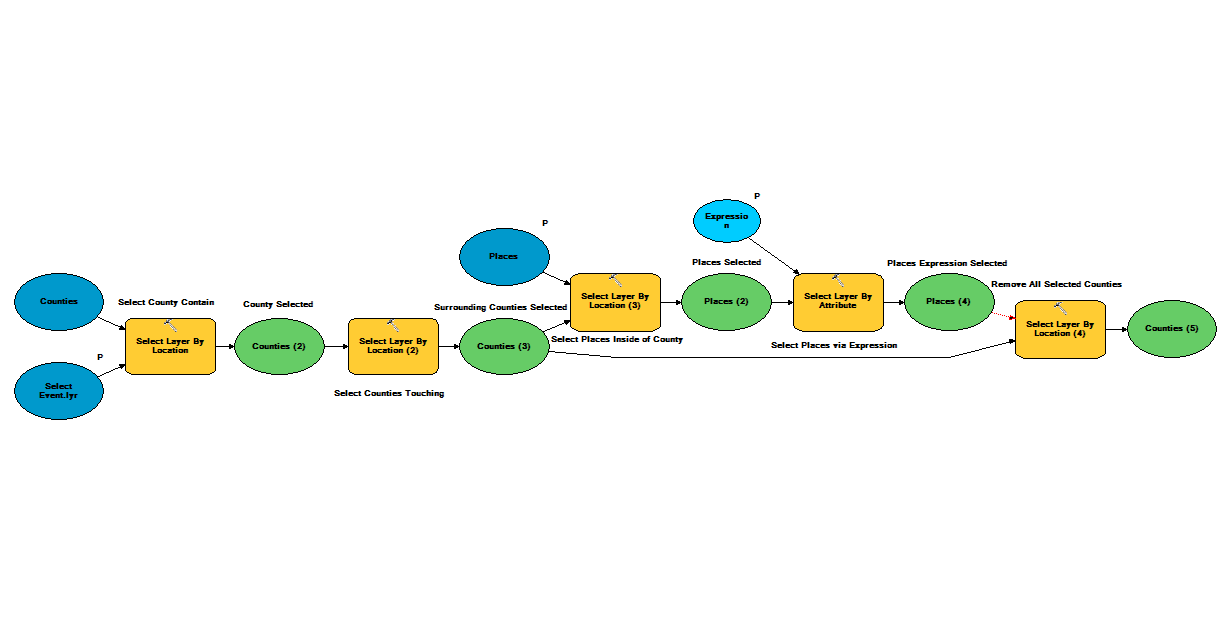
Here is a model that does a similar thing for the beginning steps. Notice that I used two separate instances of the same feature class to create the layers (The top two Make Layer tiers). That may make all the difference.
Anyway, I have a model that does something very similar and it keeps selecting a feature class against itself in two different layers to test that more than 25 property owners other than the original case owners exists within a buffer distance of the case parcels. I just keep transferring selections back and forth between the two layers based on the same feature class.
10-10-2013
07:04 AM
- Mark as New
- Bookmark
- Subscribe
- Mute
- Subscribe to RSS Feed
- Permalink
I have tested my model and it worked, so what error did you get?
Did you check if the paths to the data was correct?
Did you check if the paths to the data was correct?
10-10-2013
07:19 AM
- Mark as New
- Bookmark
- Subscribe
- Mute
- Subscribe to RSS Feed
- Permalink
Akos, Thanks for correcting my model. I'm not sure why it wasn't working the first time but I redownloaded it again and corrected the sources again and it worked.
Thanks to all!
Thanks to all!
- « Previous
-
- 1
- 2
- Next »
- « Previous
-
- 1
- 2
- Next »