- Home
- :
- All Communities
- :
- Products
- :
- Geoprocessing
- :
- Geoprocessing Questions
- :
- TIN to Raster
- Subscribe to RSS Feed
- Mark Topic as New
- Mark Topic as Read
- Float this Topic for Current User
- Bookmark
- Subscribe
- Mute
- Printer Friendly Page
TIN to Raster
- Mark as New
- Bookmark
- Subscribe
- Mute
- Subscribe to RSS Feed
- Permalink
Hi, I want to use 3 different series of Data in the form of TIN for a viewshed analysis. I thought to convert them to raster because as I saw, I cannot do a viewshed in the form of TIN. My problem is that when I convert TIN to Raster from the 3D Analysis toolbox, although the resolution in TIN is 10meters, in Raster is almost 30meters. Why is that? Can't i convert it to raster and to have the same resolution? The analysis at my raster is being made for 30 meters resolution or for 10 meters at last?
Thank you very much
- Mark as New
- Bookmark
- Subscribe
- Mute
- Subscribe to RSS Feed
- Permalink
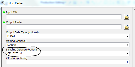
What spatial reference are you using? Did you set the sample distance to 'CELLSIZE 10' ?
- Mark as New
- Bookmark
- Subscribe
- Mute
- Subscribe to RSS Feed
- Permalink
oh no. I will do that now and i will post my results
- Mark as New
- Bookmark
- Subscribe
- Mute
- Subscribe to RSS Feed
- Permalink
Well the problem is that I have the option Cellsize 28.8839. Can i change it to 10? Why it shew a cellsize at 28.8839 by default? Won't I affect something if I change it?
- Mark as New
- Bookmark
- Subscribe
- Mute
- Subscribe to RSS Feed
- Permalink
Yes you should change it to CELLSIZE 10 if you want 10 meter cells. Unless your spatial reference has a linear unit of feet then that will produce a cell size of 10 feet.
- Mark as New
- Bookmark
- Subscribe
- Mute
- Subscribe to RSS Feed
- Permalink
And you may want to check the environment settings for the extent, and can set the cell size there.
If creating several rasters from different tins (but over the same area), for the benefit of down stream processing, get them all to line up correctly (pixel co-registration), by defining, using the environment variables, the exact extent and pixel size, and use the first as a snap raster.
- Mark as New
- Bookmark
- Subscribe
- Mute
- Subscribe to RSS Feed
- Permalink
My main concern is, if it is totally arbitrary to define by myself the cellsize, because when I chose the cellsize its value shows 28.8839 and to an another TIN with bigger resolution it rises to 30.3111!!
Because with that logic I can also put the cellsize to be 1 meter also arbitrary, but it won't correspond to reality!!
- Mark as New
- Bookmark
- Subscribe
- Mute
- Subscribe to RSS Feed
- Permalink
The computed cellsize the tool picks is the same computation it does as if you were to pick OBSERVATION. It just does a division by 250. You can arbitrarily decrease the cellsize it picks for you because it will interpolate the cell values but you just have a better resolution raster for your viewshed. What you wouldn't want to do is increase the cellsize because then you will lose data in the raster interpolation.
- Mark as New
- Bookmark
- Subscribe
- Mute
- Subscribe to RSS Feed
- Permalink
ok, very well, and the max number of points in the viewshed tool is 16 points?