- Home
- :
- All Communities
- :
- Products
- :
- Geoprocessing
- :
- Geoprocessing Questions
- :
- Re: Tessellation
- Subscribe to RSS Feed
- Mark Topic as New
- Mark Topic as Read
- Float this Topic for Current User
- Bookmark
- Subscribe
- Mute
- Printer Friendly Page
Tessellation
- Mark as New
- Bookmark
- Subscribe
- Mute
- Subscribe to RSS Feed
- Permalink
It appears that the Generate Tessellation tool at ArcGIS 10.4 does not create the shape size that is specified in the size parameter. For instance, I specify a hexagon shape size of 8.5 square miles but the shape area is actually 0.789676 square miles. Has anyone else noticed this?
- Mark as New
- Bookmark
- Subscribe
- Mute
- Subscribe to RSS Feed
- Permalink
Are you working with projected data? (this would be the prime choice)
Are the coordinate systems defined? (they should be)
This is a bit disconcerting ... from the help
The spatial reference to which the output dataset should be projected. If a spatial reference is not provided, the output will be projected to the spatial reference of the input extent. If neither has a spatial reference, the output is projected in GCS_WGS_1984. | Spatial Reference |
Generate Tessellation—Help | ArcGIS for Desktop
so basically it will try and be helpful rather than terminating the production.
- Mark as New
- Bookmark
- Subscribe
- Mute
- Subscribe to RSS Feed
- Permalink
Yes, the extents are derived from projected (state plane) data and the output spatial reference is the same.
- Mark as New
- Bookmark
- Subscribe
- Mute
- Subscribe to RSS Feed
- Permalink
can you report the extent values and the numeric value you entered for size. I suspect that you wanted 8.5 square miles, but got 8.5 something relative to the extent area
- Mark as New
- Bookmark
- Subscribe
- Mute
- Subscribe to RSS Feed
- Permalink
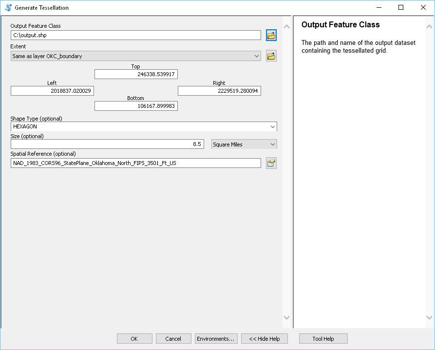
North: 246338.539917 feet
South: 106167.899983 feet
East: 2229519.280094 feet
West: 2018837.020029 feet
Spatial Reference: NAD_1983_CORS96_StatePlane_Oklahoma_North_FIPS_3501_Ft_US
Hexagon Size: 8.5 square miles
- Mark as New
- Bookmark
- Subscribe
- Mute
- Subscribe to RSS Feed
- Permalink
you should have an area 26.64 x 40 miles or 1041 sq miles or 122-ish squares of 8.5 sq miles.
if the data frame is not projected or the source file is not projected the the area reported and result returned will be a file in geographic coordinates wgs84. If your area is calculating to that small number, check its coordinate system and ensure it is in your state plane. If the number of features returned is as described above, then area should calculate out to the 8.5 sq miles in square feet (8.5 * 5260**2). If something is still amiss, then you will have to forward to tech support.
- Mark as New
- Bookmark
- Subscribe
- Mute
- Subscribe to RSS Feed
- Permalink
Like I said, the actual area of each output hexagon is 0.789676 Square Miles.
- Mark as New
- Bookmark
- Subscribe
- Mute
- Subscribe to RSS Feed
- Permalink
and you got the right-ish number of features? then there is a bug... now leave out the area line and see what the resultant is when you don't specify a size, then calculate the area in the attribute table of the resultant and check its output featurelass projection... barring that, call it in or go with the code Numpy Snippets # 3 ... Phish_Nyet ... creating sampling grids using numpy and arcpy