- Home
- :
- All Communities
- :
- Products
- :
- Geoprocessing
- :
- Geoprocessing Questions
- :
- Statistics
- Subscribe to RSS Feed
- Mark Topic as New
- Mark Topic as Read
- Float this Topic for Current User
- Bookmark
- Subscribe
- Mute
- Printer Friendly Page
- Mark as New
- Bookmark
- Subscribe
- Mute
- Subscribe to RSS Feed
- Permalink
I have a polygon layer with a bunch of polygons.
I have a raster Land Cover with a bunch of land cover types.
I want to process the data and come up with statistics of how much of each land cover type is in each of the polygons.
No idea where to start. Is there a tool that can help?
Hope I explained well enough. Thanks
Solved! Go to Solution.
Accepted Solutions
- Mark as New
- Bookmark
- Subscribe
- Mute
- Subscribe to RSS Feed
- Permalink
Hi,
Apart from Darren Wiens's suggestion, you could follow another workaround.
1) Convert the LandCover Raster to polygon.
2) Use tabulate intersection to get the area in percentage.
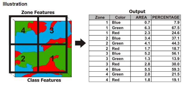
Hope it helps!!!
Think Location
- Mark as New
- Bookmark
- Subscribe
- Mute
- Subscribe to RSS Feed
- Permalink
Oh and the raster is clipped to all the Polygons.
- Mark as New
- Bookmark
- Subscribe
- Mute
- Subscribe to RSS Feed
- Permalink
Zonal Statistics as Table should do this for you.
- Mark as New
- Bookmark
- Subscribe
- Mute
- Subscribe to RSS Feed
- Permalink
I ran that and its not really what I was going for....
The raster data has a bunch of different land cover types. I was hoping for an output for each polygon with percentages for each of the land cover types ....or total counts of Raster cells for each type I can then calculate % of each type.
Polygon
Land Cover type 1 12%
Land Cover type 2 22%
Land Cover type 3 15%
Land Cover type 4 32%
- Mark as New
- Bookmark
- Subscribe
- Mute
- Subscribe to RSS Feed
- Permalink
Oh, you may want to check Tabulate Area. With both of these, if you have overlapping polygons, you will have to process zone features individually, since the zones are converted to raster (flattened), internally.
- Mark as New
- Bookmark
- Subscribe
- Mute
- Subscribe to RSS Feed
- Permalink
Hi,
Apart from Darren Wiens's suggestion, you could follow another workaround.
1) Convert the LandCover Raster to polygon.
2) Use tabulate intersection to get the area in percentage.
Hope it helps!!!
Think Location
- Mark as New
- Bookmark
- Subscribe
- Mute
- Subscribe to RSS Feed
- Permalink
Jayanta...thanks
The big question is would this work with overlapping polygons?
- Mark as New
- Bookmark
- Subscribe
- Mute
- Subscribe to RSS Feed
- Permalink
The area % would be calculated for each feature irrespective of the overlapping extent.
Think Location