Turn on suggestions
Auto-suggest helps you quickly narrow down your search results by suggesting possible matches as you type.
Cancel
- Home
- :
- All Communities
- :
- Products
- :
- Geoprocessing
- :
- Geoprocessing Questions
- :
- Re: Selecting the greatest Polygons
Options
- Subscribe to RSS Feed
- Mark Topic as New
- Mark Topic as Read
- Float this Topic for Current User
- Bookmark
- Subscribe
- Mute
- Printer Friendly Page
09-13-2012
04:18 AM
- Mark as New
- Bookmark
- Subscribe
- Mute
- Subscribe to RSS Feed
- Permalink
[ATTACH=CONFIG]17657[/ATTACH]
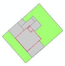
I have two Layer. The once Layer contain parcels (green), the other Layer contains bulidings (grey).
Can I select the greatest Polygon by overlapping of the two layers for every parcel?
[ATTACH=CONFIG]17658[/ATTACH]
Thanks for answering.
I have two Layer. The once Layer contain parcels (green), the other Layer contains bulidings (grey).
Can I select the greatest Polygon by overlapping of the two layers for every parcel?
[ATTACH=CONFIG]17658[/ATTACH]
Thanks for answering.
Solved! Go to Solution.
1 Solution
Accepted Solutions
by
Anonymous User
Not applicable
09-17-2012
09:38 PM
- Mark as New
- Bookmark
- Subscribe
- Mute
- Subscribe to RSS Feed
- Permalink
Original User: m.gasior
Here's an another approach:
1. Add "Building_Area" field of long integer type to your buildings feature class (the type is integer because this field will be used in Join later)
2. Fill this field with area - calculate area (Calculate Geometry) or copy values from Shape_Area field (Field Calculator) (decimal part of numbers will be truncated but integer part should be enough to differentiate buildings)
3. Perform Spatial Join: Target Features=Buildings, Join Features=Parcels. You can remove for clarity all fields from Field Map except "BuildingID", "Building_Area", "ParcelID".
4. Perform Summary Statistics on the feature class after spatial join. Statistics Field="Building_Area" with statistics type MAX; Case Field="ParcelID" (you receive a table where you have parcelID and maximum area of a building)
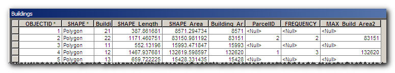
5. Join attributes from the table received in step 4 to original buildings feature class where join field are "Building_Area" and "MAX_Building_Area". You should get a table like that:
[ATTACH=CONFIG]17753[/ATTACH]
6. To select the largest building in a parcel just Select by Attribute those building where "ParcelID" IS NOT NULL.
Here's an another approach:
1. Add "Building_Area" field of long integer type to your buildings feature class (the type is integer because this field will be used in Join later)
2. Fill this field with area - calculate area (Calculate Geometry) or copy values from Shape_Area field (Field Calculator) (decimal part of numbers will be truncated but integer part should be enough to differentiate buildings)
3. Perform Spatial Join: Target Features=Buildings, Join Features=Parcels. You can remove for clarity all fields from Field Map except "BuildingID", "Building_Area", "ParcelID".
4. Perform Summary Statistics on the feature class after spatial join. Statistics Field="Building_Area" with statistics type MAX; Case Field="ParcelID" (you receive a table where you have parcelID and maximum area of a building)
5. Join attributes from the table received in step 4 to original buildings feature class where join field are "Building_Area" and "MAX_Building_Area". You should get a table like that:
[ATTACH=CONFIG]17753[/ATTACH]
6. To select the largest building in a parcel just Select by Attribute those building where "ParcelID" IS NOT NULL.
7 Replies
09-13-2012
07:55 AM
- Mark as New
- Bookmark
- Subscribe
- Mute
- Subscribe to RSS Feed
- Permalink
So what you want to do is select the largest building in each parcel, right?
by
Anonymous User
Not applicable
09-13-2012
10:05 AM
- Mark as New
- Bookmark
- Subscribe
- Mute
- Subscribe to RSS Feed
- Permalink
Original User: Klaassen
Yes that is right.
Yes that is right.
09-13-2012
02:08 PM
- Mark as New
- Bookmark
- Subscribe
- Mute
- Subscribe to RSS Feed
- Permalink
In modelbuilder this is how I would do it:
Duncan
- Use select by location to select all the buildings
- Export Selection
- Sort (Descending) exported table based upon polygon area
- Get first row and the unique ID of the polygon
- Select by Attribute on the original buildings layer using extracted ID.
Duncan
by
Anonymous User
Not applicable
09-15-2012
03:04 AM
- Mark as New
- Bookmark
- Subscribe
- Mute
- Subscribe to RSS Feed
- Permalink
Original User: Klaassen
I fear, I have not understood you.
The extend of the polygons are very different. Exist the posibility to comparing the polygons in aech particular parcel?
I have 170000 Polygons (buildings) allotted of 120000 parcels (properties).
I fear, I have not understood you.
The extend of the polygons are very different. Exist the posibility to comparing the polygons in aech particular parcel?
I have 170000 Polygons (buildings) allotted of 120000 parcels (properties).
09-17-2012
10:08 AM
- Mark as New
- Bookmark
- Subscribe
- Mute
- Subscribe to RSS Feed
- Permalink
Maybe you can use Model Builder and iterate through the parcels, selecting the buildings for each iteration and somehow extract the largest building area in the building selection and save that in a field in the parcel layer. Later you could join the building layer with the parcel layer using that area and then mark a field in the parcel layer with the parcel number, unjoin them. This would mark the largest building in each parcel with the parcel number.
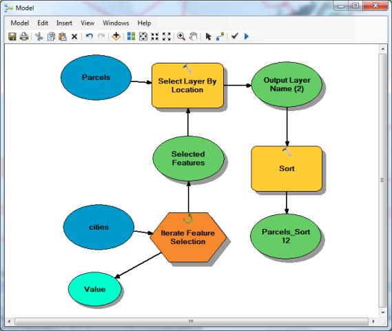
Using Model Builder I set up a temp file with a similar situation (several polygons inside larger polygons). I was able to iterate through the large polygons and select by location the smaller ones and sort the smaller selected polygons by shape area descending (put largest on top), but I didn't have time to figure out the rest of the steps.
Maybe an ArcPy script is needed.
[ATTACH=CONFIG]17769[/ATTACH]
by
Anonymous User
Not applicable
09-17-2012
09:38 PM
- Mark as New
- Bookmark
- Subscribe
- Mute
- Subscribe to RSS Feed
- Permalink
Original User: m.gasior
Here's an another approach:
1. Add "Building_Area" field of long integer type to your buildings feature class (the type is integer because this field will be used in Join later)
2. Fill this field with area - calculate area (Calculate Geometry) or copy values from Shape_Area field (Field Calculator) (decimal part of numbers will be truncated but integer part should be enough to differentiate buildings)
3. Perform Spatial Join: Target Features=Buildings, Join Features=Parcels. You can remove for clarity all fields from Field Map except "BuildingID", "Building_Area", "ParcelID".
4. Perform Summary Statistics on the feature class after spatial join. Statistics Field="Building_Area" with statistics type MAX; Case Field="ParcelID" (you receive a table where you have parcelID and maximum area of a building)
5. Join attributes from the table received in step 4 to original buildings feature class where join field are "Building_Area" and "MAX_Building_Area". You should get a table like that:
[ATTACH=CONFIG]17753[/ATTACH]
6. To select the largest building in a parcel just Select by Attribute those building where "ParcelID" IS NOT NULL.