- Home
- :
- All Communities
- :
- Products
- :
- Geoprocessing
- :
- Geoprocessing Questions
- :
- select layer by location returns empty results
- Subscribe to RSS Feed
- Mark Topic as New
- Mark Topic as Read
- Float this Topic for Current User
- Bookmark
- Subscribe
- Mute
- Printer Friendly Page
select layer by location returns empty results
- Mark as New
- Bookmark
- Subscribe
- Mute
- Subscribe to RSS Feed
- Permalink
Hi,
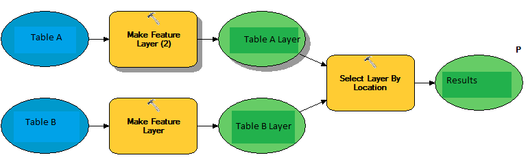
What i intend to do is to get all points from Table A that fall within some records of Table B.
- Table A: point geometry. Represents events that occur in certain spots
- Table B: polygon geometry. Represents geographic, non overlapping, areas
- I turn them into feature layers so they can be fed to "select layer by location".
- "Table A layer" is the input feature
- "Table B layer" contains the selecting features
I've checked visually that there indeed exist points in table A that fall within polygons present in Table B, however all i get, when i publish the service, is an empty collection in "results".
Any ideas,
thanks
Solved! Go to Solution.
- Mark as New
- Bookmark
- Subscribe
- Mute
- Subscribe to RSS Feed
- Permalink
Sure, in the in mean time, for a shapefile to work it needs the shp file,
the shx, and the dbf, the shp file stores all of the geometry information
and uses the object ID to connect the geometry to the attribute file (the
dbf file) one of the attributes that is pushed to attribute table is the
shape to let you know what kind of shape your attributes are associated
with. If I choose the attribute file at any point to create features from,
this file is static by itself, at this point the shapefile is meaningless
unless I have the other 2 files that the attributes are associated with.
If I see coordinate fields in this dbf file they are associated with the
point location, the centroid of a polygon, or the centroid of a line
feature. So, when I create a layer from this table the only thing the
table will give me is a point shapefile, because the program only sees one
cooridinate associated with the record. If I use the actual shapefile
associated with the attibute file then I will get the polygon or line that
is associated with the attribute field, because the program looks at the
attribute table and sees the shape attribute, it sees that it needs
polygons, it hits to shapefile and sees yes I have polygon's associated
with this table, and returns the polygons. This gives a very rough
overview of what is happening. This is the same if you are looking at an
Oracle feature class or a SQL feature class, there are separate tables for
the attributes and the geometry for each feature class that you have in the
database.
- Mark as New
- Bookmark
- Subscribe
- Mute
- Subscribe to RSS Feed
- Permalink
thanks for the explanation. i wonder why shapefiles are stored in separate files instead of a unique compressed folder in the likes of a .war file.
for exploration purposes, which would be the geometry tables. Browsing from an oracle client, the only strange tables i see are the d's the a's an the s's.
d's and a's, as far as i understand, are just for versioning control. are the s's (e.g. s14_idx$) the tables with the actual geometry?
thanks
- Mark as New
- Bookmark
- Subscribe
- Mute
- Subscribe to RSS Feed
- Permalink
Hi David,
Here are what those tables are used for:
A##: Versioning changes that have been inserted or updated
D##: Versioning changes that have been deleted
F##: Feature information for SDEBinary or SDELOB feature classes
S##: Geometry information for SDEBinary or SDELOB feature classes
ArcGIS Help (10.2, 10.2.1, and 10.2.2)
-Chris
- Mark as New
- Bookmark
- Subscribe
- Mute
- Subscribe to RSS Feed
- Permalink
thanks christian
- Mark as New
- Bookmark
- Subscribe
- Mute
- Subscribe to RSS Feed
- Permalink
i cannot show you actual data - sensitive info - but what i can indeed do is to generate mock data and replicate the error. i'll give it a try tomorrow and, hopefully, show you damaged records.
Thanks for all your help.
- Mark as New
- Bookmark
- Subscribe
- Mute
- Subscribe to RSS Feed
- Permalink
Sounds good.
-
Vandana
- Mark as New
- Bookmark
- Subscribe
- Mute
- Subscribe to RSS Feed
- Permalink
Here is a help with all of the potential files associated with a shapefile.
http://resources.arcgis.com/en/help/main/10.1/index.html#/Shapefile_file_extensions/005600000003000000/
- Mark as New
- Bookmark
- Subscribe
- Mute
- Subscribe to RSS Feed
- Permalink
What I suspect is happening is that table B maybe converted to a point file as well, because the geometry attribute is static in any table it is populated from the actual layer that the table is associated with. If you add the table into the model, there is only one point associated with each record in the table it select and that is the centroid of the polygon in stored in the geometry table. This is the location that displays when you use the convert polygon feature to point feature tool. Do you receive any errors when you run the model?
- Mark as New
- Bookmark
- Subscribe
- Mute
- Subscribe to RSS Feed
- Permalink
The model runs smoothly -no errors and correctly selecting the points within the polygons- with the tables generated from the two shapefiles. (let's call those tables A_gen and B_gen to differentiate them from the original non-working tables)
A_gen is a point type.
B_gen is a polygon type.
When i right-click the shapes in arccatalog, shows "point" for A.shp and "polygon" for B.shp.
When you say "...you use the convert polygon feature to point feature tool", i get a bit confused, i don't think i'm doing that. As far as i understand, the only processing being made to the B table in the model (now updated to use B_gen instead) is to turn that table with polygonal geometry into a polygonal feature layer so it can be fed to teh "select layer by location" tool.
Am i right on that?
thanks
- Mark as New
- Bookmark
- Subscribe
- Mute
- Subscribe to RSS Feed
- Permalink
I am sorry I used that as an example to clarify my thoughts, you are right
that is not what you are doing, sorry for the confusion. That is correct,
the select by location tool needs an actual shapefile or geodatabase
feature class to work.