- Home
- :
- All Communities
- :
- Products
- :
- Geoprocessing
- :
- Geoprocessing Questions
- :
- Re: "New" ArcGIS Pro Create Locator Question
- Subscribe to RSS Feed
- Mark Topic as New
- Mark Topic as Read
- Float this Topic for Current User
- Bookmark
- Subscribe
- Mute
- Printer Friendly Page
"New" ArcGIS Pro Create Locator Question
- Mark as New
- Bookmark
- Subscribe
- Mute
- Subscribe to RSS Feed
- Permalink
I’ve been banging around with the latest version (2.6 Pro) of the Address Locator Tool and have come up with a few Issues:
1. I don’t understand in the HELP section what this means?
- “Locators created by this tool cannot be used as a local locator in ArcMap.”

-Does this mean we cannot use the Create Locator Tool when using ArcGIS Pro installed on a Local Desktop Machine?
2. When using the New Create Locator tool in 2.6 for what I assume is a very basic or standard Address Locator, using in the locator pane, right click, Properties, you cannot adjust the Geocoding option to change how far off a road or line segments the Geocoded address is to be offset? Or spelling sensitivity options?
- The "Legacy" Tool:
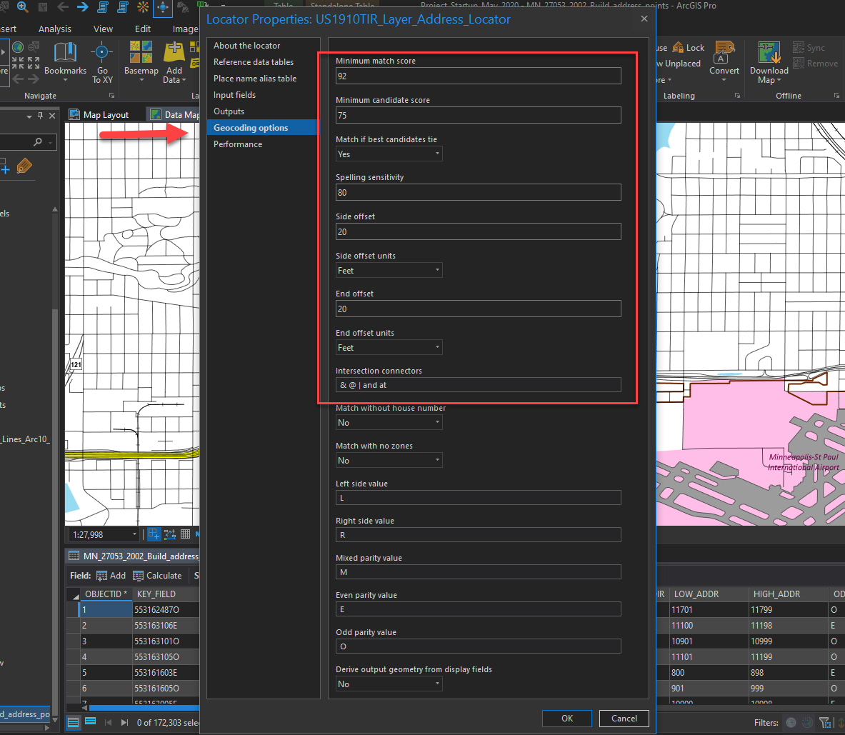
The "new" Address Locator Tool from Pro 2.6
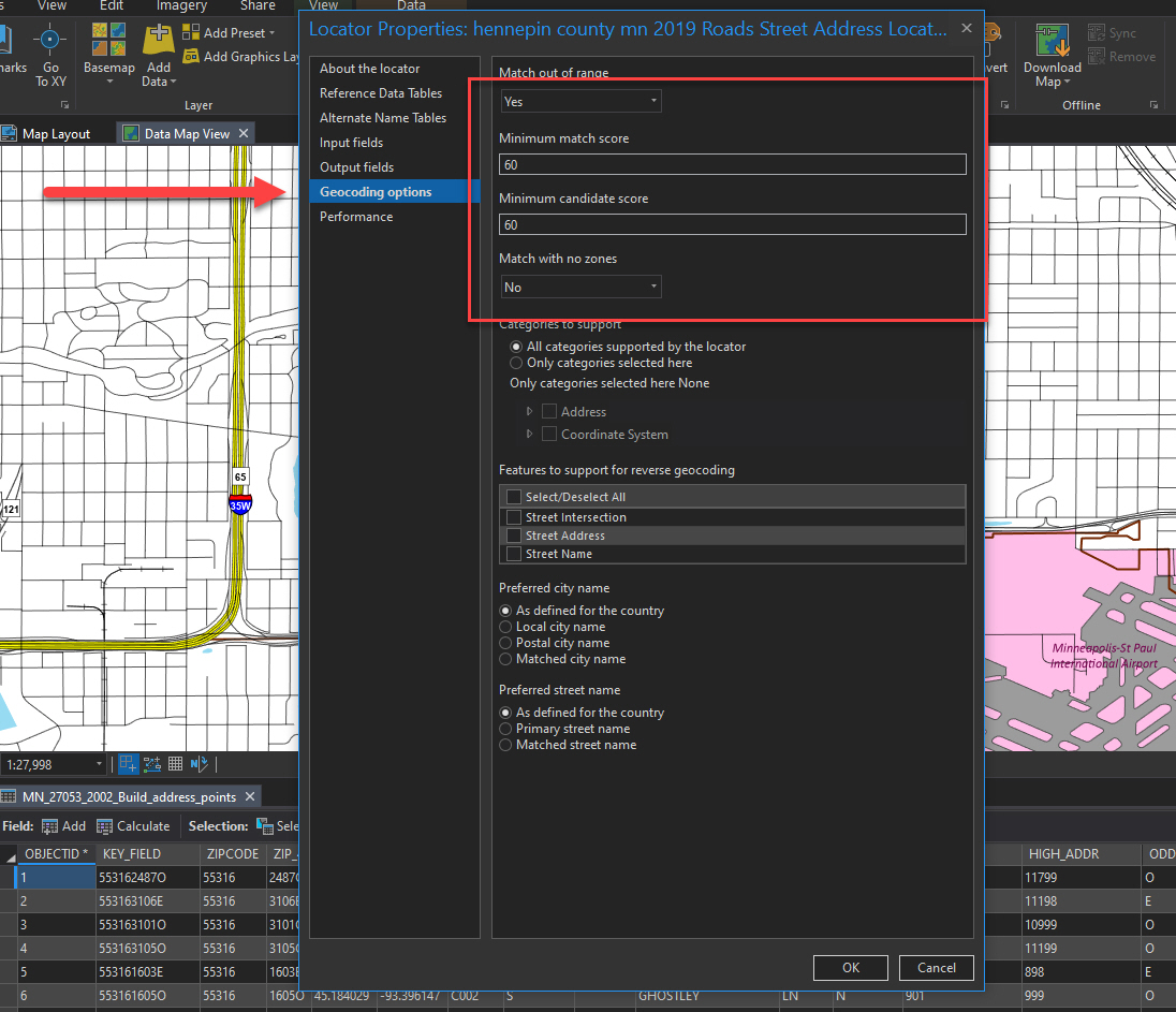
Am I missing where in the new version, where one can adjust the placement options for the outputs from the Address Locator?
Thanks
Brian
- Mark as New
- Bookmark
- Subscribe
- Mute
- Subscribe to RSS Feed
- Permalink
I haven't had the chance to create locators yet in 2.6, so I can't comment on your second question.
However, locators that are created with the Create Locator tool in Pro have never been able to be used in ArcMap. If you publish such a locator to a service, I believe it can be consumed in ArcMap.
- Mark as New
- Bookmark
- Subscribe
- Mute
- Subscribe to RSS Feed
- Permalink
Aaahhh, my bad, I just realized in re-reading my question, help said ArcMap not ArcGIS, good catch, all my locator experience is with in-house local desktop machine work, I've never worked with published or geocoding services to be shared online, Thanks.
- Mark as New
- Bookmark
- Subscribe
- Mute
- Subscribe to RSS Feed
- Permalink
No problem.
Looping in Shana Britt to see if she can comment on question #2.
- Mark as New
- Bookmark
- Subscribe
- Mute
- Subscribe to RSS Feed
- Permalink
Brian:
Locators created with the Create Locator tool in ArcGIS Pro can be used in ArcMap after the locator has been published as a geocode service from ArcGIS Pro. A locator based on the StreetAddress role built with the Create Locator tool has a default offset of 3m that cannot be changed. The locators created with the Create Locator tool do not have a spelling sensitivity property to adjust in the locator properties. The following topics discuss the geocoding options that can be adjusted in the new locators created by the Create Locator tool:
- Tips for improving geocoding quality—ArcGIS Pro | Documentation
- Tips for improving geocoding performance—ArcGIS Pro | Documentation
- Additional tuning options—ArcGIS Pro | Documentation
Are addresses not being matched by the locator you created based on the StreetAddress role that are related to misspellings? What is the reason you need to adjust the side offset of the locator based on street segments?
-Shana
- Mark as New
- Bookmark
- Subscribe
- Mute
- Subscribe to RSS Feed
- Permalink
Shana
In the sample below is a small zoomed in clip of one of the many types of Spatial joins we process. In this case the green area is a rough representation of an service area submitted for processing and due to the size and scope of the geography, snapping the polygons to match the road base is time prohibited. By increasing the offset of the address points to say offset 35 ft, in this case, allows for a higher percentage of correct analysis being obtained. Depending on the quality of the service area, offset adjustments have been made to the geocoders offsets, and the appropriate coded addresses are run against the particular national service areas. Tight for tight, loose for loose.
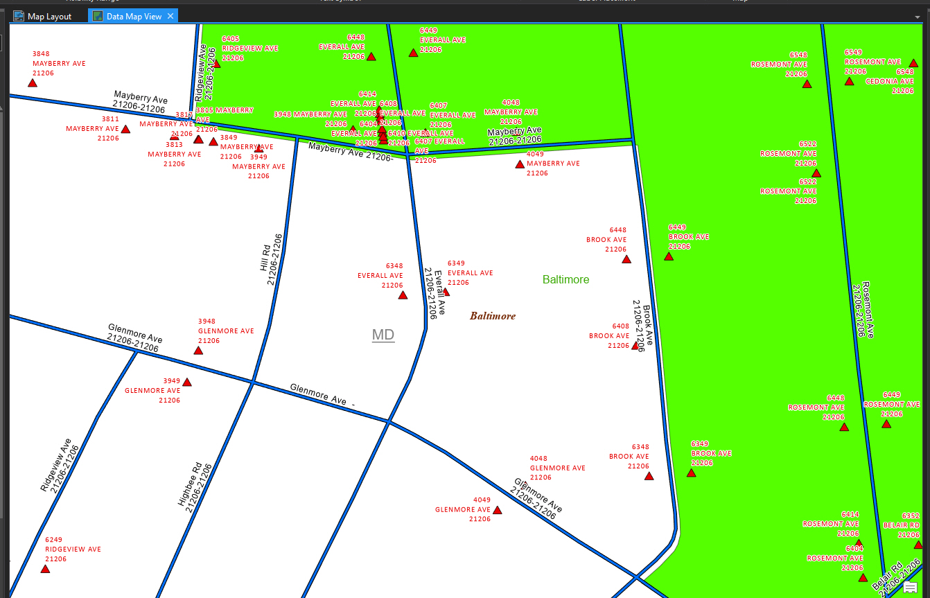
Its a little extreme but a 2 ft offset, which we rarely would use, would both add and eliminate address depending on the quality of the service area and we found that certain offset settings work best with certain service areas.
In relation to spelling, historically we run it pretty tight, however we haven't run a recent analysis to see how the newer ArcGIS Pro 2.6 Locator likes or dislikes misspellings.
Not being able to adjust offsets is a game changer, in the wrong direction us at TR
Thanks
-Brian
- Mark as New
- Bookmark
- Subscribe
- Mute
- Subscribe to RSS Feed
- Permalink
Brian:
Thanks for providing more details surrounding your usage of side offsets in your workflow.
Is it possible to perform a spatial join between the street data and the service area polygons using the search radius parameter set to your offset value you'd like to use to join the service area attributes to the the street segments? If this is possible, when you build the locator with the Create Locator tool, you can add a custom output field in the tool under optional parameters then map the service area attribute(s) to the new custom output field in the field mapping. The value from the custom output field will show in the outputs of the geocode results when you geocode the table.
-Shana
- Mark as New
- Bookmark
- Subscribe
- Mute
- Subscribe to RSS Feed
- Permalink
Hi Shana
Currently, that is not possible. we will continue to use the ArcMap legacy geocoders until these option are added to the ArcGIS Pro Address Locators.
Thanks again
Brian
- Mark as New
- Bookmark
- Subscribe
- Mute
- Subscribe to RSS Feed
- Permalink
Brian:
I would encourage you to submit an enhancement request through Support or ArcGIS Ideas.
-Shana
- Mark as New
- Bookmark
- Subscribe
- Mute
- Subscribe to RSS Feed
- Permalink
Good Evening, I see with the New ArcPro 2.7 update, we will no longer be able to use ArcPro for our Geocoding projects utilizing the legacy Address locator. We will have to now use exclusively ArcMap10x for these projects for the foreseeable future.
It seems strange that while we are supposed to migrate our workflows to ArcPro because while its the platform that's the future at ESRI, we're forced in this case, to now regress back to Arcmap10x for this issue.
Is coding the offsets variables back into the program that difficult? there appears to be more than enough space in the interface. I have no comprehension on how hard it is to duplicate the process from the legacy tools to add those offset options back into the ArcPro Version. but it would save us the pain of backwards movement.
Thanks for letting me vent about this issue.
Brian