Turn on suggestions
Auto-suggest helps you quickly narrow down your search results by suggesting possible matches as you type.
Cancel
- Home
- :
- All Communities
- :
- Products
- :
- Geoprocessing
- :
- Geoprocessing Questions
- :
- Re: Publishing network analyst tool as service.
Options
- Subscribe to RSS Feed
- Mark Topic as New
- Mark Topic as Read
- Float this Topic for Current User
- Bookmark
- Subscribe
- Mute
- Printer Friendly Page
Publishing network analyst tool as service.
Subscribe
2421
4
06-26-2013 01:20 PM
06-26-2013
01:20 PM
- Mark as New
- Bookmark
- Subscribe
- Mute
- Subscribe to RSS Feed
- Permalink
I have just started working Network analyst in my recent project. I have created network analyst data set and than develop a tool that calculates distance between two given point. The tool is shown in the attached file. I run it on ArcMAP it works fine, than i published it on server , however i received following error:
High Unresolved 00082 Output parameter Route in task Model1roadsonemoretry requires a result map service
So I want to know what is this error as I want to use my tool as Geoprocessing service that takes my arguments and returns me the best route and route length. Is it must for this network analysis to provide with a result map service or is there any other way to do this.
when i used the option asynchronous and checked view with map service , the service is published, but I am not sure how to use it from my Flex application.
please help.
regards
nadeem
4 Replies
06-26-2013
01:36 PM
- Mark as New
- Bookmark
- Subscribe
- Mute
- Subscribe to RSS Feed
- Permalink
Your attachment isn't in the post, so I'm just guessing.
Have you done a "select" to pull the output route out from the Solve?
The output of Solve is actually multiple layers. I have a feeling this, as your final output node is why you're getting the 00082 error (a datatype which GP Server can't return, but could draw in a result map service).
I'd recommend going through this help link and comparing what you have to the sample:
http://resources.arcgis.com/en/help/main/10.1/#/Shortest_Route/00570000009q000000/
06-27-2013
01:46 AM
- Mark as New
- Bookmark
- Subscribe
- Mute
- Subscribe to RSS Feed
- Permalink
Your attachment isn't in the post, so I'm just guessing.
Have you done a "select" to pull the output route out from the Solve?
The output of Solve is actually multiple layers. I have a feeling this, as your final output node is why you're getting the 00082 error (a datatype which GP Server can't return, but could draw in a result map service).
I'd recommend going through this help link and comparing what you have to the sample:
http://resources.arcgis.com/en/help/main/10.1/#/Shortest_Route/00570000009q000000/
Sorry , I have now uploaded the model . I need advices 🙂 I am looking on the link u sent to me.may be it would give me an idea.
thanks
regards
nadeem
06-27-2013
07:49 AM
- Mark as New
- Bookmark
- Subscribe
- Mute
- Subscribe to RSS Feed
- Permalink
Sorry , I have now uploaded the model . I need advices 🙂 I am looking on the link u sent to me.may be it would give me an idea.
thanks
regards
nadeem
Dear Kevin H.
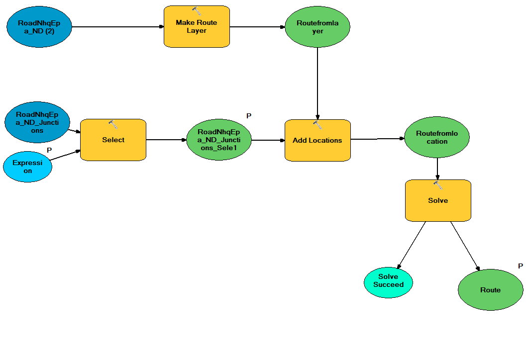
Following your advice i used Select Data however i also unchecked Route as output parameter of my model and it worked. But now it does not draw the line between the given stop rather it gives length of distance between two stops. In case i also want to draw the line than what should i do . I have visited your provided link .the example uses network analysis as service but it does not use any mGP model . Can u please put some light which way is better to use network analysis .1. as GP service or 2 as Network Analysis serviceplease see me attached model with modification.
regards
nadeem
06-27-2013
07:59 AM
- Mark as New
- Bookmark
- Subscribe
- Mute
- Subscribe to RSS Feed
- Permalink
Based on the model (screen shot), it looks like your final Select is pulling out STOPS.
I think you want it to pull out ROUTES.
Double click the Select inside Modelbuilder and use the drop down to select the routes layer.
This version of the tutorial was written for 10.0, but explains the model a bit more:
http://help.arcgis.com/en/arcgisdesktop/10.0/help/#/GP_service_example_Shortest_route_on_a_street_ne...
The help makes this point:
"Network analysis layers (such as Route) are not supported output parameter data types for ArcGIS Server clients. So the Select Data tool is used to get the Routes sublayer from the Route layer."