- Home
- :
- All Communities
- :
- Products
- :
- Geoprocessing
- :
- Geoprocessing Questions
- :
- Re: MultiPoint features to Polygon features help?
- Subscribe to RSS Feed
- Mark Topic as New
- Mark Topic as Read
- Float this Topic for Current User
- Bookmark
- Subscribe
- Mute
- Printer Friendly Page
MultiPoint features to Polygon features help?
- Mark as New
- Bookmark
- Subscribe
- Mute
- Subscribe to RSS Feed
- Permalink
I have multipoint features. I want to convert this to polygons.
I used the following tool using convext hull, but I'm missing areas. See picture.
Minimum Bounding Geometry—Data Management toolbox | ArcGIS Desktop
Is there a tool or ArcPy way to get the polygon boundary of the multipoint feature?
Peace & Love!
Jerry
- Mark as New
- Bookmark
- Subscribe
- Mute
- Subscribe to RSS Feed
- Permalink
If you are referring to the areas marker with the blue polygons:
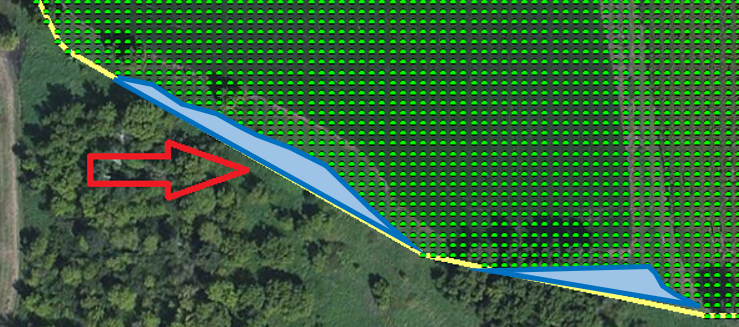
... then that is normal when creating a ConvexHull.
It seems that your points are evenly spaced, so you could consider converting to raster those points (using the spacing between the point as cell size) and then convert the raster to polygon.
- Mark as New
- Bookmark
- Subscribe
- Mute
- Subscribe to RSS Feed
- Permalink
What you are looking for is the 'concave' hull there are few implementations readily available for arcmap, so Xander's approach is the best to go with