- Home
- :
- All Communities
- :
- Products
- :
- Geoprocessing
- :
- Geoprocessing Questions
- :
- Re: Make xy event layer issues 10.1
- Subscribe to RSS Feed
- Mark Topic as New
- Mark Topic as Read
- Float this Topic for Current User
- Bookmark
- Subscribe
- Mute
- Printer Friendly Page
Make xy event layer issues 10.1
- Mark as New
- Bookmark
- Subscribe
- Mute
- Subscribe to RSS Feed
- Permalink
Are there known issues with the xy event tool in 10.1? Or any suggestions/pre processing I could do to make this work?
Thanks,
Kevin
- Mark as New
- Bookmark
- Subscribe
- Mute
- Subscribe to RSS Feed
- Permalink
Can you upload the table you are working with, or post a sample?
- Mark as New
- Bookmark
- Subscribe
- Mute
- Subscribe to RSS Feed
- Permalink
Having the same problem at a fully patched ArcGIS 10.2.2 Standard w/64bit background geoprocessing on Windows 7 Pro 64bit SP1
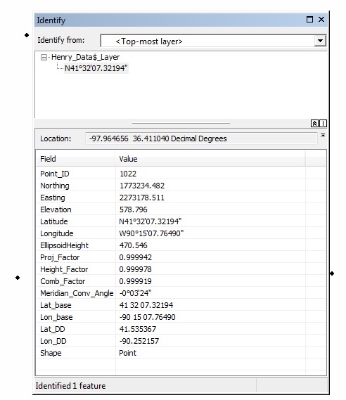
The attached image displays a point "Identify." Notice the Lat_DD and Lon_DD attributes (used to create the points) do not match the "Location" values.
The attached File Geodatabase (zipped into a single file) contains two tables:
- GCP_Table - Used the Lat_DD and Lon_DD fields to create the XY layer.
- CreatedByMakeXY - Notice the XY Coordinate system is set to what I used to create the event layer
BTW - Same results using ArcGIS 10.0
Is this enough information? Thank you
- Mark as New
- Bookmark
- Subscribe
- Mute
- Subscribe to RSS Feed
- Permalink
Hi Bruce,
I didn't see an attachment. Can you try uploading it again?
- Mark as New
- Bookmark
- Subscribe
- Mute
- Subscribe to RSS Feed
- Permalink
Resend attachments...
The attached image displays a point "Identify." Notice the Lat_DD and Lon_DD attributes (used to create the points) do not match the "Location" values.
The attached File Geodatabase (zipped into a single file) contains two tables:
- GCP_Table - Used the Lat_DD and Lon_DD fields to create the XY layer.
- CreatedByMakeXY - Notice the XY Coordinate system is set to what I used to create the event layer
- Mark as New
- Bookmark
- Subscribe
- Mute
- Subscribe to RSS Feed
- Permalink
Still no attachments. Try starting a new thread and then uploading your zip file.
- Mark as New
- Bookmark
- Subscribe
- Mute
- Subscribe to RSS Feed
- Permalink
The attachments are there and are downloadable from my message(s).
Maybe site privileges or some other geonet settings are not allowing you to seem them. I'm checking into that possibility.
- Mark as New
- Bookmark
- Subscribe
- Mute
- Subscribe to RSS Feed
- Permalink
Bruce,
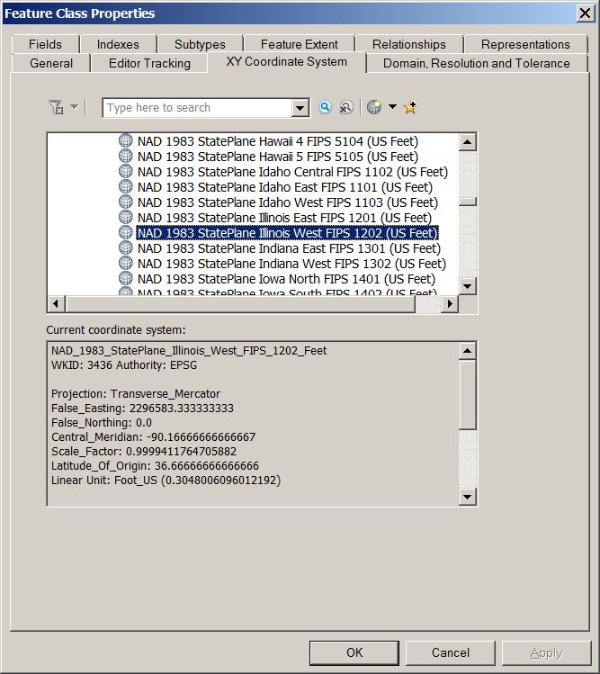
The properties page of your layer indicates that you created the points using state plane (feet), NOT degrees decimal.
I think that might be a bit of a problem.
When you load a table into make XY events, you have to specify the correct XY columns & what the numbers in those columns represent, ie the correct coordinate system.
Neil
- Mark as New
- Bookmark
- Subscribe
- Mute
- Subscribe to RSS Feed
- Permalink
Choosing "WGS 1984" (as given by Jake Skinner) from "Geographic Coordinate Systems/World" seems to have corrected the problem. The points are now in the proper locations.
The information below was given for the points, so I assumed they should be created using the "projection"
- Coordinate System: US State Plane 1983 (US survey feet)
- Datum: NAD 83(NA2011)
- Zone: Illinois West 1202
- Geoid: GEOID12A (Conus)
- Vertical Datum: NAVD88
So, from the information given, what told you I should use WGS 1984? My guess is because Lat/Long values were used indicating "world coordinates"!?!
Thank you Jake and Neil
- Mark as New
- Bookmark
- Subscribe
- Mute
- Subscribe to RSS Feed
- Permalink
Yes, since the lat/long values were in the format they were in. State Plane coordinates would be a 6 digit and 7 digit coordinate. Ex: 237219.09, 2693160.81