- Home
- :
- All Communities
- :
- Products
- :
- Geoprocessing
- :
- Geoprocessing Questions
- :
- Make XY Event Layer available in WebApp Builder
- Subscribe to RSS Feed
- Mark Topic as New
- Mark Topic as Read
- Float this Topic for Current User
- Bookmark
- Subscribe
- Mute
- Printer Friendly Page
Make XY Event Layer available in WebApp Builder
- Mark as New
- Bookmark
- Subscribe
- Mute
- Subscribe to RSS Feed
- Permalink
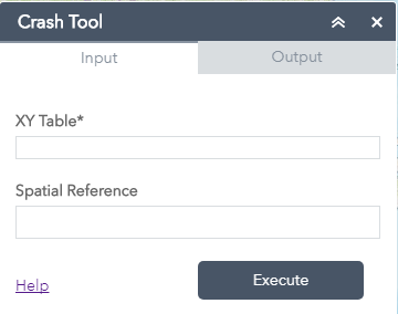
I am trying to provide my users with a tool that will let them upload .xls and/or .csv files containing xy coordinate data from their systems (desktop, network drive, thumb drive, etc), perform a process and map the result as a point layer. Please view the attached pdf which illustrates what I have tried and failed at (i.e. creating a geoprocessing tool and publishing as a service). I am definitely doing something wrong. Can someone please point me in the right direction.
Note: This tool will be incorporated into Portal for ArcGIS WebApp Builder. I am aware that coordinates can be mapped in Portal for ArcGIS, however it only accepts lat/long. We work with UTM and I will not want to pass the headache of always converting to lat/long before mapping to my users or take on the burden myself.
I look forward to any help.
Lara
- Mark as New
- Bookmark
- Subscribe
- Mute
- Subscribe to RSS Feed
- Permalink
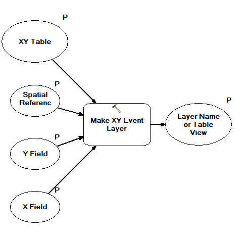
Jake, I've created a model that mimics yours as well as publishing it as a service with "Uploads" enabled. However, when I go to use the service in a WAB application the Upload button does not appear, any thoughts? Is this feature allowed via AGOL-hosted Web Apps or is it limited to Portal?
Thanks, this thread has been extremely helpful!
- Mark as New
- Bookmark
- Subscribe
- Mute
- Subscribe to RSS Feed
- Permalink
Hi Alec,
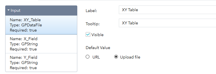
When you were configuring the widget did you specify the 'Upload file' option for the input?
- Mark as New
- Bookmark
- Subscribe
- Mute
- Subscribe to RSS Feed
- Permalink
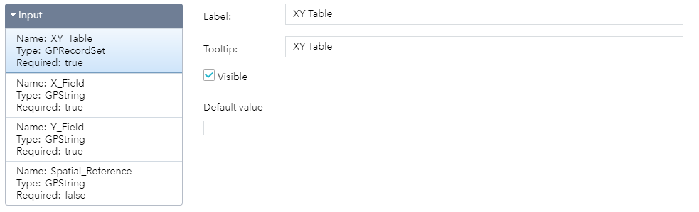
Oddly enough the "Upload file" option does not appear for me. Perhaps an issue with my model? I notice that my "Type" field under the Input is listed as "GPRecordSet" while yours is "GPDataFile".
- Mark as New
- Bookmark
- Subscribe
- Mute
- Subscribe to RSS Feed
- Permalink
Can you send a screen shot of your model?
- Mark as New
- Bookmark
- Subscribe
- Mute
- Subscribe to RSS Feed
- Permalink
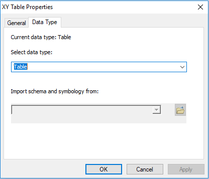
Additionally, the data type for my XY Table parameter is set as "Table" \
- Mark as New
- Bookmark
- Subscribe
- Mute
- Subscribe to RSS Feed
- Permalink
I would try starting over by re-running your model, and then re-publishing the GP service. It's strange that it's stating a GPRecordSet rather than a GPDataTable.
- « Previous
-
- 1
- 2
- Next »
- « Previous
-
- 1
- 2
- Next »