- Home
- :
- All Communities
- :
- Products
- :
- Geoprocessing
- :
- Geoprocessing Questions
- :
- How to create vector roads center lines from raste...
- Subscribe to RSS Feed
- Mark Topic as New
- Mark Topic as Read
- Float this Topic for Current User
- Bookmark
- Subscribe
- Mute
- Printer Friendly Page
How to create vector roads center lines from raster?
- Mark as New
- Bookmark
- Subscribe
- Mute
- Subscribe to RSS Feed
- Permalink
Hello. I need to know how to create roads vector center lines from raster. I have used raster classification tool to classify raster and after that reclassify tool to filter the roads from other values. After that I have used "Raster to polyline" tool and checked the Simplify box, but the results are not really good (see attachment). Does anyone know better way to solve my problem?
Thanks in advance
Solved! Go to Solution.
Accepted Solutions
- Mark as New
- Bookmark
- Subscribe
- Mute
- Subscribe to RSS Feed
- Permalink
Try Thin in the spatial analyst, before converting to polyline. It isn't going to be perfect. Even converting to multipoint won't help much since that would have to be followed by a spanning tree, which still isn't guaranteed to connect all the segments.
- Mark as New
- Bookmark
- Subscribe
- Mute
- Subscribe to RSS Feed
- Permalink
Can you show a picture of the original raster? The screenshot of the lines look like the outlines of the pixels, but this may be related to your input raster (multiple values for instance).
- Mark as New
- Bookmark
- Subscribe
- Mute
- Subscribe to RSS Feed
- Permalink
Try Thin in the spatial analyst, before converting to polyline. It isn't going to be perfect. Even converting to multipoint won't help much since that would have to be followed by a spanning tree, which still isn't guaranteed to connect all the segments.
- Mark as New
- Bookmark
- Subscribe
- Mute
- Subscribe to RSS Feed
- Permalink
Thanks a lot! Great!
- Mark as New
- Bookmark
- Subscribe
- Mute
- Subscribe to RSS Feed
- Permalink
I also want to connect lines which belongs to roads, because when I have made the raster classification some roads are cuted because of different pixel color that intersect it. How I can connect the roads now?
- Mark as New
- Bookmark
- Subscribe
- Mute
- Subscribe to RSS Feed
- Permalink
Can you share a screenshot of what you have after applying the tool suggested by Dan?
- Mark as New
- Bookmark
- Subscribe
- Mute
- Subscribe to RSS Feed
- Permalink
I got this when I have used Thin: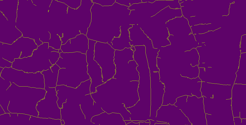
Now when I use Raster to polyline tool the results are great. Now I just need to connect divided lines.
- Mark as New
- Bookmark
- Subscribe
- Mute
- Subscribe to RSS Feed
- Permalink
If what you're getting from a simple Thin run is not doing the trick, you may want to look into the part of ArcGIS dedicated to this task: ArcScan. This used to be an separate add-on extension but now the extension it's part of the core software license. ArcScan includes interactive tools that are set up to trace the raster data and jump the gaps for you!