- Home
- :
- All Communities
- :
- Products
- :
- Geoprocessing
- :
- Geoprocessing Questions
- :
- Re: Make XY Event Layer available in WebApp Builde...
- Subscribe to RSS Feed
- Mark Topic as New
- Mark Topic as Read
- Float this Topic for Current User
- Bookmark
- Subscribe
- Mute
- Printer Friendly Page
Make XY Event Layer available in WebApp Builder
- Mark as New
- Bookmark
- Subscribe
- Mute
- Subscribe to RSS Feed
- Permalink
I am trying to provide my users with a tool that will let them upload .xls and/or .csv files containing xy coordinate data from their systems (desktop, network drive, thumb drive, etc), perform a process and map the result as a point layer. Please view the attached pdf which illustrates what I have tried and failed at (i.e. creating a geoprocessing tool and publishing as a service). I am definitely doing something wrong. Can someone please point me in the right direction.
Note: This tool will be incorporated into Portal for ArcGIS WebApp Builder. I am aware that coordinates can be mapped in Portal for ArcGIS, however it only accepts lat/long. We work with UTM and I will not want to pass the headache of always converting to lat/long before mapping to my users or take on the burden myself.
I look forward to any help.
Lara
- Mark as New
- Bookmark
- Subscribe
- Mute
- Subscribe to RSS Feed
- Permalink
Hi Omolara,
If you are working with CSV files, take a look at the Add Data widget:
- Mark as New
- Bookmark
- Subscribe
- Mute
- Subscribe to RSS Feed
- Permalink
Thanks for your reply Jake. I have looked into the Add Data Widget. It has the limitation of accepting only lat/long. I need something that will accept UTM.
Sent from my Samsung Galaxy smartphone.
- Mark as New
- Bookmark
- Subscribe
- Mute
- Subscribe to RSS Feed
- Permalink
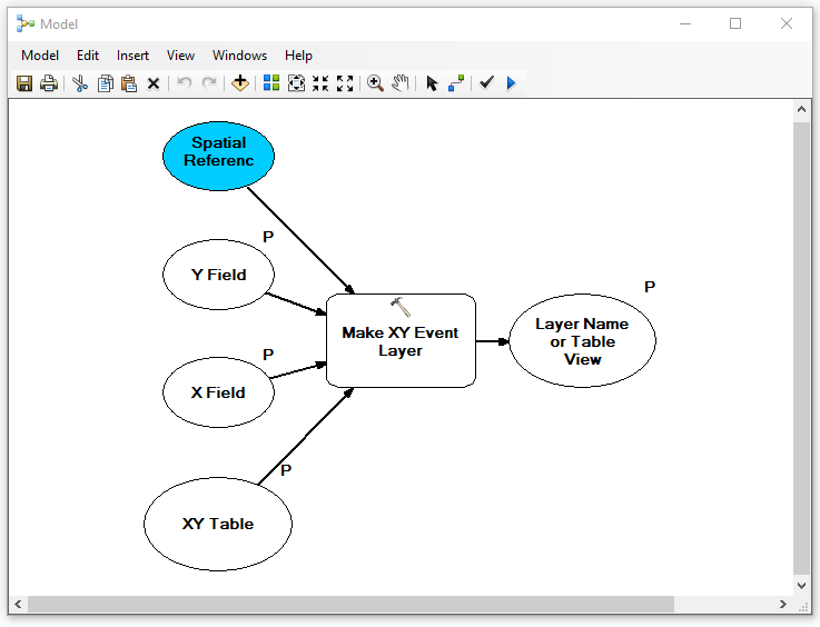
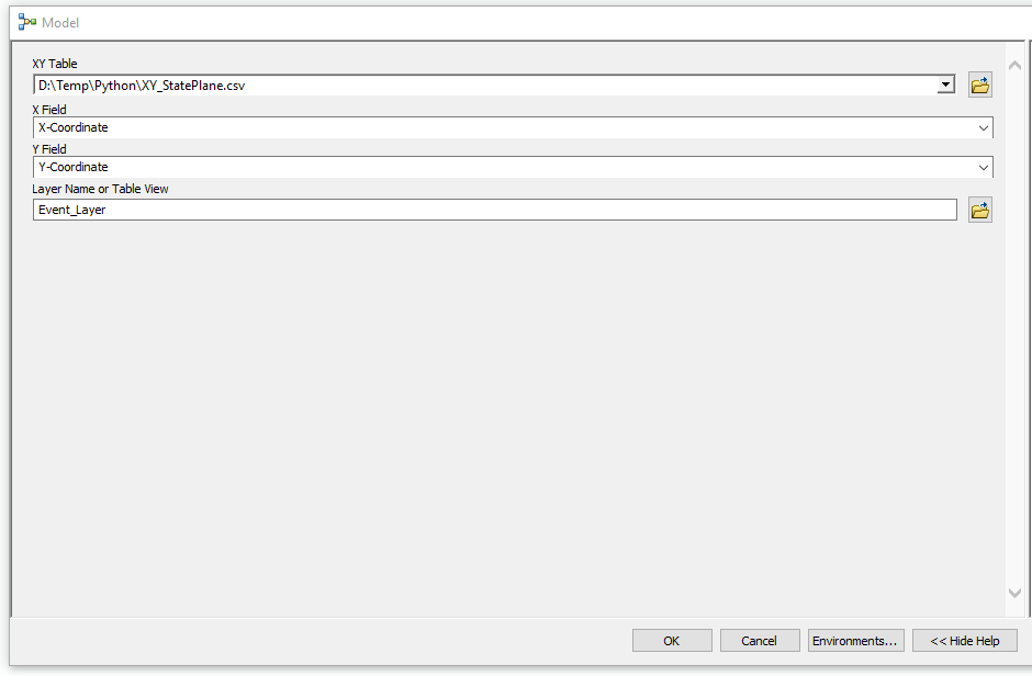
Here is a modelI was able to get to work with a CSV file. I simply added the Make XY Event Layer tool to model builder and set parameters for input, X & Y fields, and output. I set the spatial reference to the coordinate system of my choice.
I then published this to ArcGIS Server as a Geoprocessing service. I made sure to check 'Uploads' for the Capabilities so that the end user can upload a CSV file:

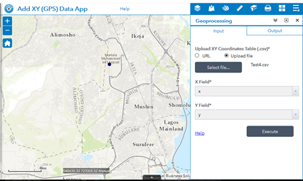
I could then successfully configure and execute this in Portal:

- Mark as New
- Bookmark
- Subscribe
- Mute
- Subscribe to RSS Feed
- Permalink
I did it!!!
Thanks so much Jake. Much appreciated.
I have another problem now. Everything worked as it should but in a list of 23 xy coordinates, only the first one was plotted. Can you tell where I missed it? I've checked over and over, don't know what I've done wrong.
Save
- Mark as New
- Bookmark
- Subscribe
- Mute
- Subscribe to RSS Feed
- Permalink
Can you upload the CSV file you are using to GeoNET for me to take a look?
- Mark as New
- Bookmark
- Subscribe
- Mute
- Subscribe to RSS Feed
- Permalink
LAMATAEnterpriseGIS what coordinate system are you using?
- Mark as New
- Bookmark
- Subscribe
- Mute
- Subscribe to RSS Feed
- Permalink
Projected Coordinate System: WGS_1984_UTM_Zone_31N
- Mark as New
- Bookmark
- Subscribe
- Mute
- Subscribe to RSS Feed
- Permalink
Omolara, I would recommend logging a case with support. I tried plotting this CSV file you sent and it displays all the points in correctly within the Web AppBuilder Application (Portal 10.5.1):

What's strange is that the GP tool is working correctly in ArcGIS Desktop 10.5.1.