Turn on suggestions
Auto-suggest helps you quickly narrow down your search results by suggesting possible matches as you type.
Cancel
- Home
- :
- All Communities
- :
- Products
- :
- Geoprocessing
- :
- Geoprocessing Questions
- :
- lambert to lat lon
Options
- Subscribe to RSS Feed
- Mark Topic as New
- Mark Topic as Read
- Float this Topic for Current User
- Bookmark
- Subscribe
- Mute
- Printer Friendly Page
lambert to lat lon
Subscribe
750
1
07-14-2012 01:56 PM
07-14-2012
01:56 PM
- Mark as New
- Bookmark
- Subscribe
- Mute
- Subscribe to RSS Feed
- Permalink
Dear users
i have a shp file map on a lambert conformal projection and i want to convert it to a standard la lon map using the Data Management/Projections and Transformation/Feature/Project tool. however i cannot figure out what projection represents the lat lon?
can you help me on this please
thank you
i have a shp file map on a lambert conformal projection and i want to convert it to a standard la lon map using the Data Management/Projections and Transformation/Feature/Project tool. however i cannot figure out what projection represents the lat lon?
can you help me on this please
thank you
1 Reply
07-16-2012
03:46 AM
- Mark as New
- Bookmark
- Subscribe
- Mute
- Subscribe to RSS Feed
- Permalink
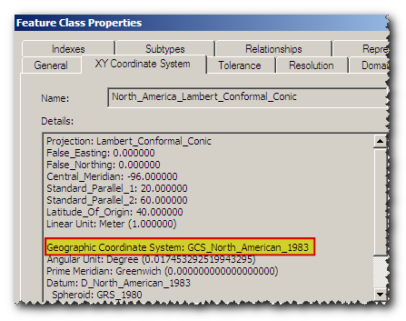
You have to identify geographic coordinate system of your data first.
Go to feature class properties and in XY Coordinate System tab you will find this information.
Here's an example:
[ATTACH=CONFIG]16117[/ATTACH]
Identified geographic coordinate system can be found in:
Coordinate Systems/Geographic Coordinate Systems folder.
for example: WGS 1984 is in World subfolder, NAD 1983 is in North America subfolder.