- Home
- :
- All Communities
- :
- Products
- :
- Geoprocessing
- :
- Geoprocessing Questions
- :
- Re: kriging with sparse weather data
- Subscribe to RSS Feed
- Mark Topic as New
- Mark Topic as Read
- Float this Topic for Current User
- Bookmark
- Subscribe
- Mute
- Printer Friendly Page
kriging with sparse weather data
- Mark as New
- Bookmark
- Subscribe
- Mute
- Subscribe to RSS Feed
- Permalink
Hello Everyone,
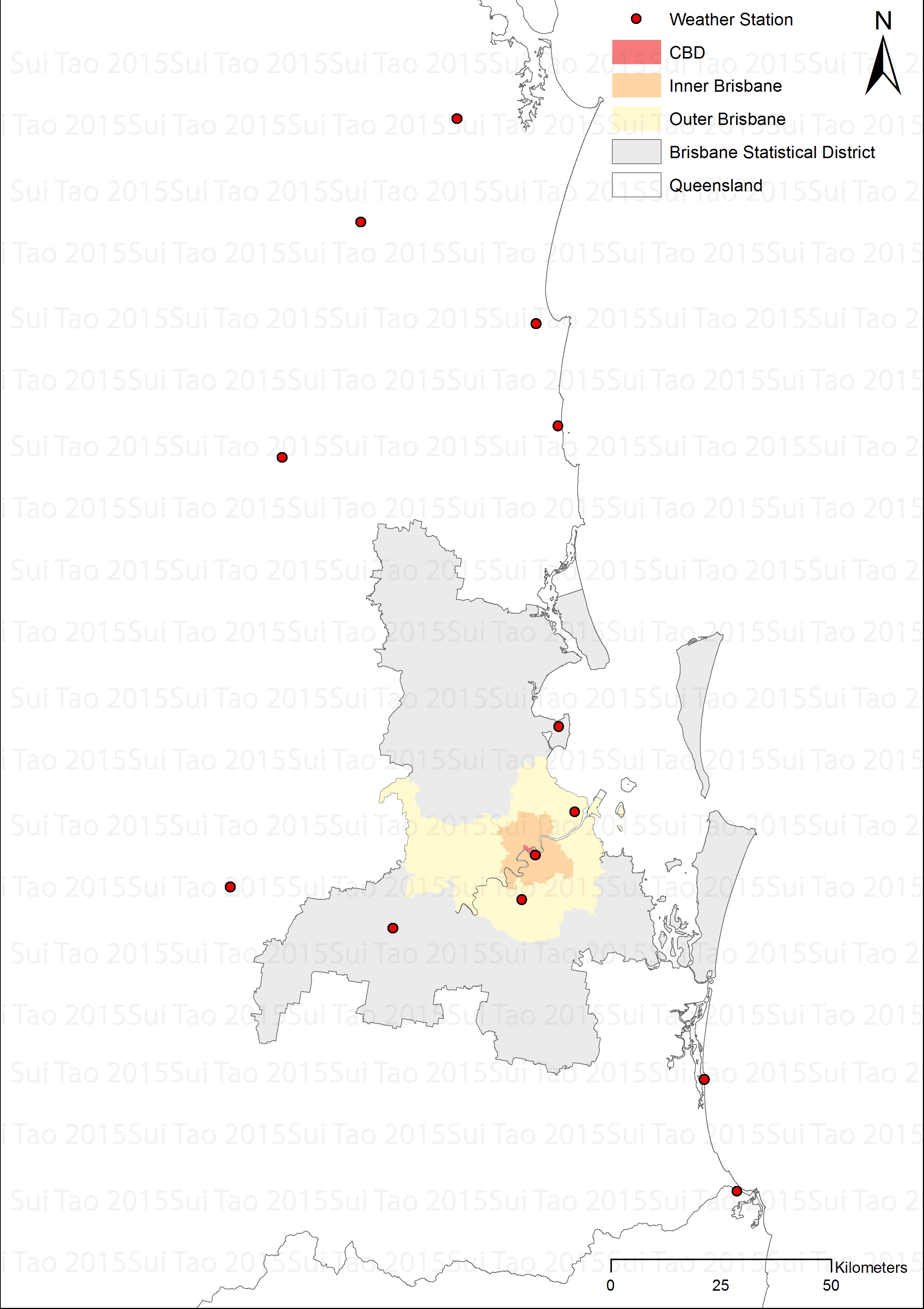
I'm trying to use spatial-based weather data (temperature, rainfall, wind, etc) to estimate and create a weather surface across Brisbane, Australia. I only have data of 13 locations in total as shown in the attached figure across Queensland, the state for which Brisbane is the capital city. It seems that kriging is a possible and proper solution to fulfill my goal. However, some suggested that at least 30 distinct locations of data were ideal to do kriging. I currently don't have other datasets and doubt there will be. So my question is how can I apply the kriging method to this rather sparse weather data to generate a reasonably acceptable results of weather surface? Do I add artificial points such as copying the same data point to nearby locations?
Any suggestions are welcome. And thank you in advance!
Best regards,
Sui Tao
- Mark as New
- Bookmark
- Subscribe
- Mute
- Subscribe to RSS Feed
- Permalink
sui,
The weather data are already via 'maximizing spatial independence among sample locations' over Greater Brisbane landsacape. Advisable to always keep in mind that sampling data (locations) are reliable, not from artificial works.
Regardsing Krigging interpolation that you intend to use onto this set of data, generally, you can do so.
On Greater Brisbane landsacape, however, it is reasonable to use other methods as well.
Personally, those results (GRID or raster surface) from two or more different methods should be very similar....
Pls update your findings, if any...
- Mark as New
- Bookmark
- Subscribe
- Mute
- Subscribe to RSS Feed
- Permalink
Besides, for more understanding the steps on geostatistics (SAS), pls refer to the article at https://support.sas.com/resources/papers/proceedings10/337-2010.pdf
- Mark as New
- Bookmark
- Subscribe
- Mute
- Subscribe to RSS Feed
- Permalink
Hi Larry,
Many thanks for your swift reply. Yet due to my own omissions, there are some unclear points.
First, I understand that certain conditions should be met for the data before applying the kriging method, e.g., normal distribution, stationary data. Considering the obvious small sample, I kinda expected there will be some skewed distribution, questionable stationarity, etc, existing in the data. In that case, if I just proceed with kriging, chances are that the results will be questionable as well (as found in another similar post arcgis 10.1 - Minimum number of samples for kriging interpolation - Geographic Information Systems S...). While it has been suggested certain preliminary tests of the data should be carried out, it seems unclear what these tests entail. Hence what pre-process (if any) should be carried out before kriging with sparse data?
Second, could you please expand a bit more on different methods you mentioned, e.g., what methods exactly can be used in this situation?
Sorry for this rudimentary questions, I'm still very much in a learning process.
Sui
- Mark as New
- Bookmark
- Subscribe
- Mute
- Subscribe to RSS Feed
- Permalink
Regarding other deterministic interpolation methods like IDW in ArcGIS, please refer to http://resources.arcgis.com/en/help/main/10.2/#/Geostatistical_Analyst_example_applications/00310000...
The link that you provided is good. In my vision, many professionals in geoscience (mining, oil & gas industires) and geomatics/ surveying present very good understanding to make use of Krigging techniques, including estimations and simulations. The reason is that they must take some advanced courses on Geostatistics and Uncertainty analysis...
Anyhow, to decide if the sampled data applied to with Kriging methods, some basics should be considered, in particular, modeling ‘covariances’, in order to prove independence of the estimate and error. In other word, if Kriging used, you are required to quantify the spatial 'autocorrelation' among measured points and account for the spatial configuration of the sample points around the prediction location, … (minimum numbers are not necessary, but 'more is better' is true...).
So, you need pay attention to the stochastic properties of the random field and the various degrees of stationarity assumed, before which Krigging method is used to model your data…
If learning with ArcGIS (Geostatistics Analyst), it is good to follow the tutorial at http://resources.arcgis.com/en/help/main/10.2/#/Introduction_to_the_ArcGIS_Geostatistical_Analyst_Tu...
- Mark as New
- Bookmark
- Subscribe
- Mute
- Subscribe to RSS Feed
- Permalink
With the local kriging with KRIGE2D Procedure from SAS/STAT, the number is set with the minimum 20.
Please refer to KRIGE2D Procedure at SAS/STAT(R) 13.2 User's Guide
- Mark as New
- Bookmark
- Subscribe
- Mute
- Subscribe to RSS Feed
- Permalink
Hi Larry,
Really sorry for the belated reply. Had to put kriging aside due to overloaded work.
I now have the chance to do kriging on sparse weather data. Here's a sample of the kriging surface using 14 data points of relative humidity.
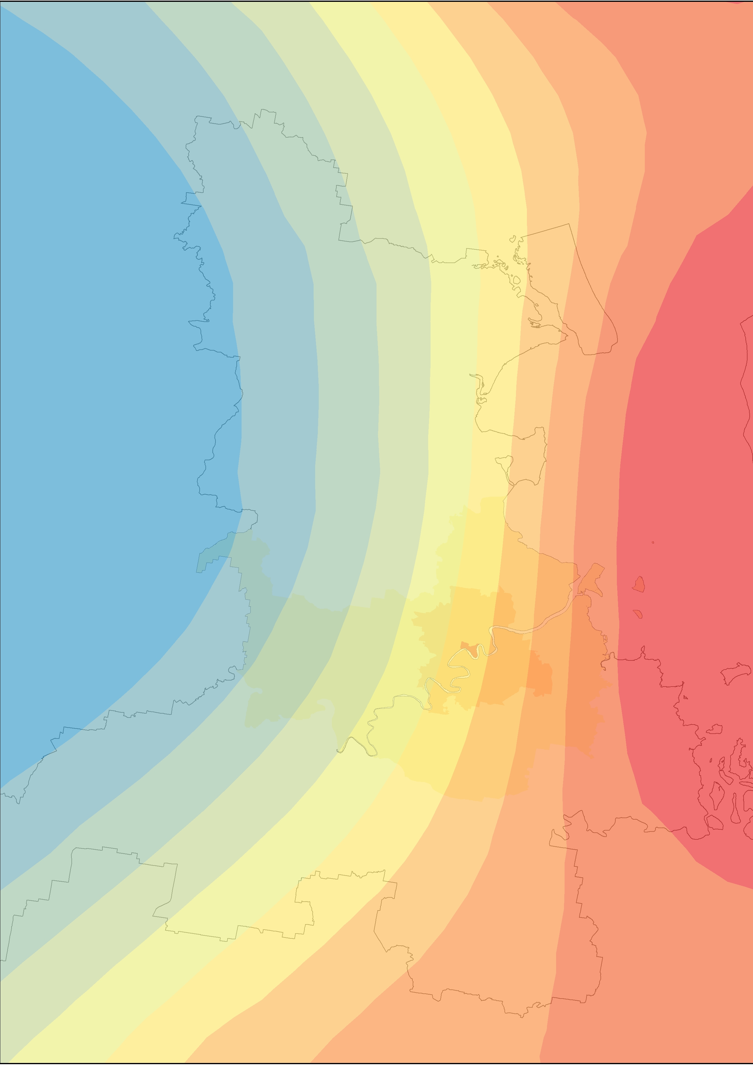
And here's some statistical modelling results:
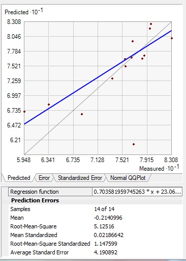
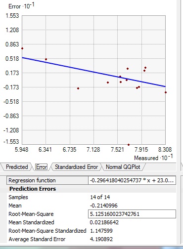
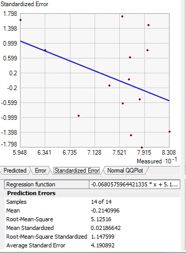
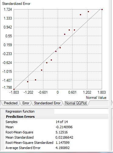
I used ordinary krigining without changing other settings in the ArcGIS.
While not ideal, the results seem to be not so bad either--the standardised root-mean-square is moderately larger than 1, the average standard error is also moderately different from root-mean-square. What do you think about the results and any suggestions for improvement?
Many thanks,
Sui
- Mark as New
- Bookmark
- Subscribe
- Mute
- Subscribe to RSS Feed
- Permalink
advisable to learn geostatistics via SAS or R.
Pls refer to Geostatistical R Package - Documentation , which includes sample data and steps...
- Mark as New
- Bookmark
- Subscribe
- Mute
- Subscribe to RSS Feed
- Permalink
Hi Larry,
Many thanks for the detailed reply. I will have a go and get back to you concerning the results.
Regards,
Sui