Turn on suggestions
Auto-suggest helps you quickly narrow down your search results by suggesting possible matches as you type.
Cancel
- Home
- :
- All Communities
- :
- Products
- :
- Geoprocessing
- :
- Geoprocessing Questions
- :
- Interpreting Raster Properties
Options
- Subscribe to RSS Feed
- Mark Topic as New
- Mark Topic as Read
- Float this Topic for Current User
- Bookmark
- Subscribe
- Mute
- Printer Friendly Page
Interpreting Raster Properties
Subscribe
1781
4
09-11-2013 10:06 AM
09-11-2013
10:06 AM
- Mark as New
- Bookmark
- Subscribe
- Mute
- Subscribe to RSS Feed
- Permalink
I know this is a very elementary question so please excuse what might sound so simple. I am trying to calculate the total area of a raster dataset that has a specified Cell Size of 1 m. I used IDW to interpolate carbon lbs/per area and I???m confused as to how to understand the Raster properties. I can see how many Columns and Rows there are and I know that the inputs are in UTM and I also see the No Data values but I???m unclear as to how to understand all of this. I???ve read and re-read the Help articles and remain just as confused. I see the Extents but I think these numbers correspond the geographic location of the data, not the size of the area. I also used the Zonal Stats tool to Sum the amount of Carbon in the study area and the table shows Count, Area and Sum but I don???t know how to interpret these.
Any help is greatly appreciated.
Thankyou!
Natasha
[ATTACH=CONFIG]27364[/ATTACH]
Any help is greatly appreciated.
Thankyou!
Natasha
[ATTACH=CONFIG]27364[/ATTACH]
4 Replies
09-11-2013
09:56 PM
- Mark as New
- Bookmark
- Subscribe
- Mute
- Subscribe to RSS Feed
- Permalink
Natasha,
Have you read this section of the help? You really need a handle on these concepts to work with raster data effectively -- so if you haven't read this overview yet I highly recommend it to you:
ArcGIS 10.0 help: What is Raster Data?
You seem to have a start as the extents are the extent of the dataset, which includes all cells, those with data and cells that are NoData.
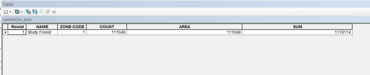
Count is the number of data cells found in that zone, Area is the total area (count times the square of the cell size used in the calculation), and Sum is the sum of the values data cells in the zone. The online help for Zonal Statistics as Table has an example that shows this pretty clearly.
You may be wrong about the cell size though -- you said the raster dataset has a cell size of 1m but your screen shot shows a cell size of 0.87.
Hope this helps.
Have you read this section of the help? You really need a handle on these concepts to work with raster data effectively -- so if you haven't read this overview yet I highly recommend it to you:
ArcGIS 10.0 help: What is Raster Data?
You seem to have a start as the extents are the extent of the dataset, which includes all cells, those with data and cells that are NoData.
Count is the number of data cells found in that zone, Area is the total area (count times the square of the cell size used in the calculation), and Sum is the sum of the values data cells in the zone. The online help for Zonal Statistics as Table has an example that shows this pretty clearly.
You may be wrong about the cell size though -- you said the raster dataset has a cell size of 1m but your screen shot shows a cell size of 0.87.
Hope this helps.
09-12-2013
07:07 AM
- Mark as New
- Bookmark
- Subscribe
- Mute
- Subscribe to RSS Feed
- Permalink
Natasha,
Have you read this section of the help? You really need a handle on these concepts to work with raster data effectively -- so if you haven't read this overview yet I highly recommend it to you:
ArcGIS 10.0 help: What is Raster Data?
You seem to have a start as the extents are the extent of the dataset, which includes all cells, those with data and cells that are NoData.
Count is the number of data cells found in that zone, Area is the total area (count times the square of the cell size used in the calculation), and Sum is the sum of the values data cells in the zone. The online help for Zonal Statistics as Table has an example that shows this pretty clearly.
You may be wrong about the cell size though -- you said the raster dataset has a cell size of 1m but your screen shot shows a cell size of 0.87.
Hope this helps.
Curt I appreciate your taking the time to respond to my question. I have read and reread the Help articles and I'm still a bit stuck.
In the above screenshot I made a mistake and said my Cell Size was 1...that was for another raster. But in the above shot, what would the total area of the raster be? 333,638 meters? data is in UTM.
Thankyou very much.
Natasha
09-12-2013
08:21 AM
- Mark as New
- Bookmark
- Subscribe
- Mute
- Subscribe to RSS Feed
- Permalink
In the above screenshot I made a mistake and said my Cell Size was 1...that was for another raster. But in the above shot, what would the total area of the raster be? 333,638 meters? data is in UTM.
The total area of the raster is the total area of all the cells in the raster's extent: rows x columns x (cell size)2. (All rasters are rectangular.)
In the case of your screen shot, using my handy Python calculator:
>>> 333 * 638 * (0.87999999 ** 2)
164524.37759962608
The area of data cells is a different question; that number is in your zonal statistics output for each zone in the "zone raster" you provided to the tool.
09-12-2013
08:40 AM
- Mark as New
- Bookmark
- Subscribe
- Mute
- Subscribe to RSS Feed
- Permalink
The total area of the raster is the total area of all the cells in the raster's extent: rows x columns x (cell size)2. (All rasters are rectangular.)
In the case of your screen shot, using my handy Python calculator:>>> 333 * 638 * (0.87999999 ** 2) 164524.37759962608
The area of data cells is a different question; that number is in your zonal statistics output for each zone in the "zone raster" you provided to the tool.
Curt you are a hero for making things so much clearer to me. So the 333 638 are two separate numbers reflecting Columns and Rows! I get it now. I was reading that number as an integer and was totally confused as to what it represented. So the area would be in square meters I'm assuming?
The Zone Stats number's reflect the numeric data in the Field for pounds of carbon per square meter within a Forest Study area.
I've included a screen shot of the numbers that came back from running the Tool and am not quite sure what they reflect.
I've been reading and re-reading the Help articles and I guess I'm just unfamiliar with how these raster datasets behave and I'm getting used to them.
Again, thankyou so much for clearing things up for me....the above was just a mis-read of the information in the Raster Properties box....good grief.
Natasha