Turn on suggestions
Auto-suggest helps you quickly narrow down your search results by suggesting possible matches as you type.
Cancel
- Home
- :
- All Communities
- :
- Products
- :
- Geoprocessing
- :
- Geoprocessing Questions
- :
- Re: Inquiry shape file object together (Points wit...
Options
- Subscribe to RSS Feed
- Mark Topic as New
- Mark Topic as Read
- Float this Topic for Current User
- Bookmark
- Subscribe
- Mute
- Printer Friendly Page
Inquiry shape file object together (Points with lines)
Subscribe
2037
4
01-21-2013 03:40 AM
01-21-2013
03:40 AM
- Mark as New
- Bookmark
- Subscribe
- Mute
- Subscribe to RSS Feed
- Permalink
Hi!
Iam a newbie with ArcGIS;
I will like to know if it is possible to "inquiry" objects to know a distance between two points with 2 shapes files
Is it possible with ArcGIS ?
Thx alot!
Iam a newbie with ArcGIS;
I will like to know if it is possible to "inquiry" objects to know a distance between two points with 2 shapes files
- Shape files with points. (Each point have a number)
- Shape file with lines.
Is it possible with ArcGIS ?
Thx alot!
4 Replies
01-21-2013
11:26 PM
- Mark as New
- Bookmark
- Subscribe
- Mute
- Subscribe to RSS Feed
- Permalink
Hi!
Iam a newbie with ArcGIS;
I will like to know if it is possible to "inquiry" objects to know a distance between two points with 2 shapes files
- Shape files with points. (Each point have a number)
- Shape file with lines.
I will like to inquiry 2 numbers to have the distance like google maps.
Is it possible with ArcGIS ?
Thx alot!
Hi Sylvain,
Assuming you need the straight line distance you can have a look at the Near tool: http://resources.arcgis.com/en/help/main/10.1/index.html#//00080000001q000000. As you can see from the help it will find the distance from the point featureclass to the nearest position on the line featureclass.
If that's not what you need, you can try describing your problem more closely.
01-23-2013
12:14 PM
- Mark as New
- Bookmark
- Subscribe
- Mute
- Subscribe to RSS Feed
- Permalink
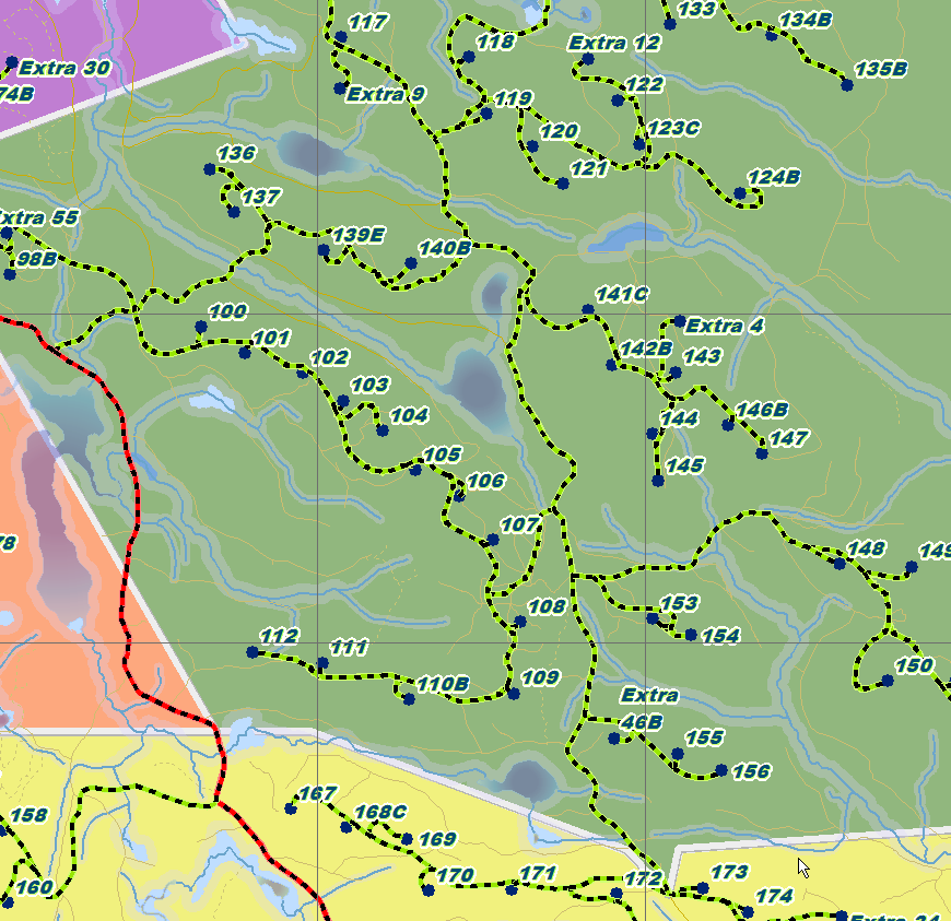
This is a screenshot
I want to inquiry to know the distance betweeen ex:
119-107 (Shortest road)
172-136
148-117
.. etc.
Blue Points are in a Shape File
Road (Red & Green) are in a Shape file.
[ATTACH=CONFIG]20992[/ATTACH]
You are describing a Network Analyst problem. You need that extension to trace road segments between two destinations along the shortest path. You also have to create a Network Dataset from your road network to use the tool. Look in the help for Network Analyst and then you may want to go to that Forum topic to ask more questions.
01-24-2013
03:49 AM
- Mark as New
- Bookmark
- Subscribe
- Mute
- Subscribe to RSS Feed
- Permalink
You are describing a Network Analyst problem. You need that extension to trace road segments between two destinations along the shortest path. You also have to create a Network Dataset from your road network to use the tool. Look in the help for Network Analyst and then you may want to go to that Forum topic to ask more questions.
Ok i will read network Analyst help
Thx alot