- Home
- :
- All Communities
- :
- Products
- :
- Geoprocessing
- :
- Geoprocessing Questions
- :
- Re: How to joint data from another layer based on ...
- Subscribe to RSS Feed
- Mark Topic as New
- Mark Topic as Read
- Float this Topic for Current User
- Bookmark
- Subscribe
- Mute
- Printer Friendly Page
How to joint data from another layer based on spatial location for Point feature & Line feature?
- Mark as New
- Bookmark
- Subscribe
- Mute
- Subscribe to RSS Feed
- Permalink
Hi Friends,
Example see the image.
- Mark as New
- Bookmark
- Subscribe
- Mute
- Subscribe to RSS Feed
- Permalink
There are spatial joins... and attribute joins and relates...
Without having to open the *.rar files, which one are you trying to accomplish?
- Mark as New
- Bookmark
- Subscribe
- Mute
- Subscribe to RSS Feed
- Permalink
I think you will have to provide a little more explanation. There are multiple featureclasses in the 2 file geodatabases that you provided. From your screenshot I can derive that you want to update the fc COM_Box, but with which other featureclass? Is it InteriorSpace perhaps?

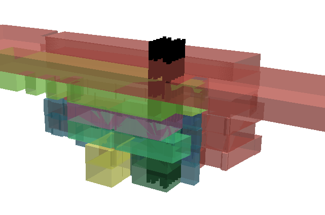
A thing to keep in mind is that the information has floors. So polygons overlap at the locations of the points and therefore a point will fall in multiple polygons and could receive multiple different ID's: See a 3D shot of a small part of the data. The black points have been extruded to show the effect and only the 1st to the 6th floor has been visualized:
- Mark as New
- Bookmark
- Subscribe
- Mute
- Subscribe to RSS Feed
- Permalink
Just had another look. Since both layers (if the ones I mentioned are the ones you mean) have a Floor ID and this ID could be used to identify the polygon from which the ID should be extracted to update the points featureclass. This would require some scripting.