- Home
- :
- All Communities
- :
- Products
- :
- Geoprocessing
- :
- Geoprocessing Questions
- :
- How to harmonize two different contour data in Arc...
- Subscribe to RSS Feed
- Mark Topic as New
- Mark Topic as Read
- Float this Topic for Current User
- Bookmark
- Subscribe
- Mute
- Printer Friendly Page
How to harmonize two different contour data in ArcGIS 10?
- Mark as New
- Bookmark
- Subscribe
- Mute
- Subscribe to RSS Feed
- Permalink
Hi guys, I'm having a difficulty in combining two different contour data from different sources and scale. i got my data from IFSAR having 1:10,000 scale with 5m contour interval and the other one from primary data in the field with 1:5,000 scale and 2m contour interval. What will be the right procedures to come up with DEM out of these two data? Thank you.
- Mark as New
- Bookmark
- Subscribe
- Mute
- Subscribe to RSS Feed
- Permalink
It depends on the accuracy of your two contour files.
For example, if both spatially are accurate enough (i.e., match on the same values of contours), the combination of two vector files (the GP tool ‘merge’) is first step for GIS uses;
However, if distorted on same values of contour, the lower accuracy of 1:10000 contours from IFSAR should be spatially adjusted to match the higher accuracy of surveying contours 1:5000 before merging..
- Mark as New
- Bookmark
- Subscribe
- Mute
- Subscribe to RSS Feed
- Permalink
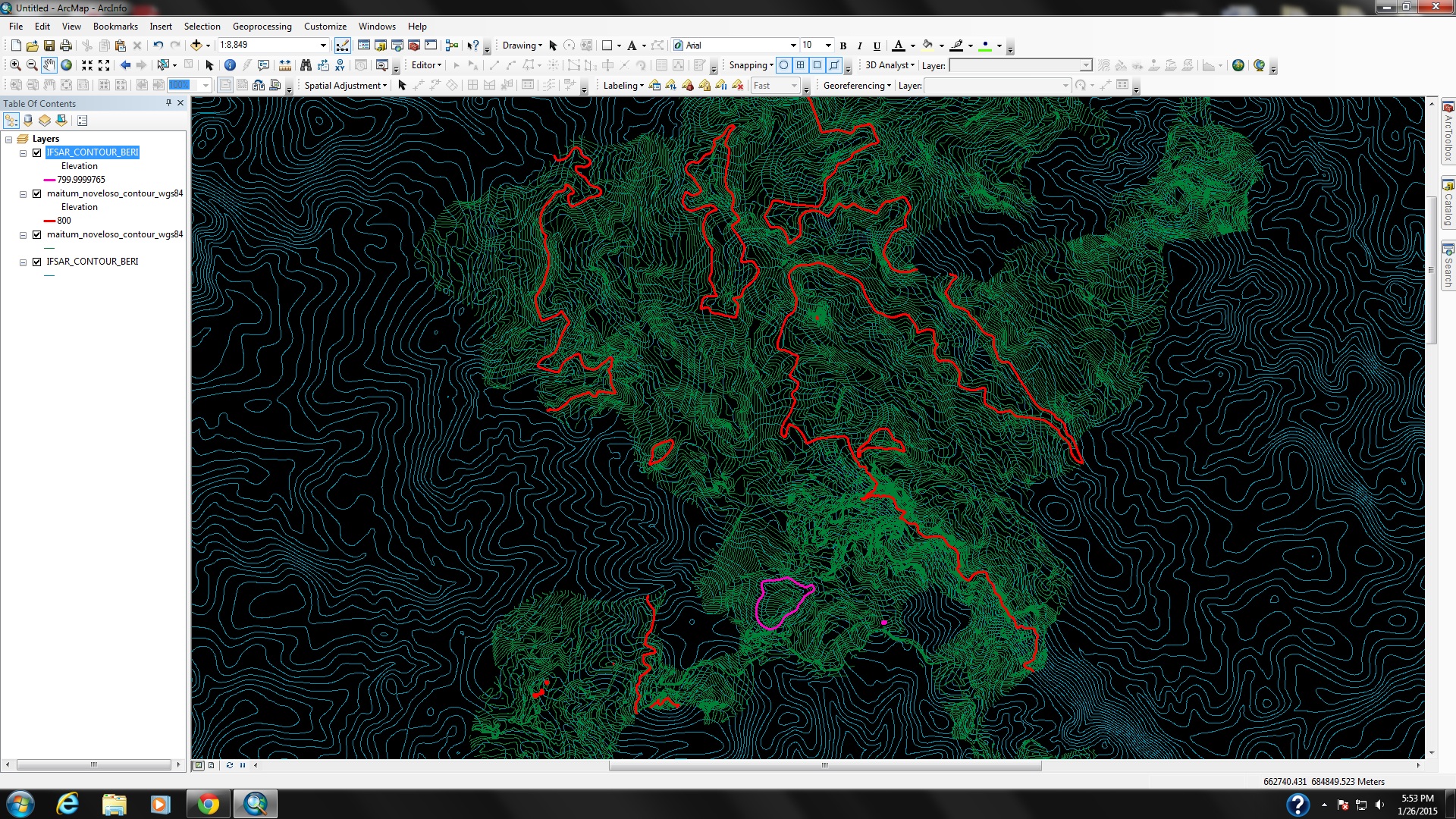
Thank you for the comment, I'm really just confused because as you can see on the picture below the lines from the two data doesn't fit at all even though it both has the same projection. The red lines indicate the 800m elevation from the field data while the pink line is the 800m elevation of the IFSAR data. What will be my other parameter to reconcile these data since i don't have any layer files in IFSAR unlike in the field data that i have layers of roads and rivers. Please help me on this. Thank you.
- Mark as New
- Bookmark
- Subscribe
- Mute
- Subscribe to RSS Feed
- Permalink
Honestly, you are facing a challenge.
From your snapshot, my view is:
Your higher-resolution DEM derived from IFSAR is not reliable. Do you have any accuracy report on this dataset from data provider? Are those SAR images from space-borne RADARSAT or other?
Generally, without rectification along with GCPs or other references, this higher-resolution DEM data should NOT be unified with your DEM from surveying, which is more reliable and accurate...
The best way to do the rectification is that it should be re-started from two SAR pairs, before generating DEM.
- Mark as New
- Bookmark
- Subscribe
- Mute
- Subscribe to RSS Feed
- Permalink
Your right about it, one of our consultants advised me to convert the contour lines into point data then combine the 2 data sets, convert it to TIN then re-contour or interpolate it with 5m contour interval. I'm not satisfied with the output because it produces a lot of curvatures/triangulated forms when it was converted to TIN data.
Is it possible to fill the gaps of the field data using IFSAR?
- Mark as New
- Bookmark
- Subscribe
- Mute
- Subscribe to RSS Feed
- Permalink
leslie,
In practice, you have an effective way to solve this challenge, i.e., to fill the gaps of the field data using IFSAR.
How? Please refer to Fill Voids in DEM
- Mark as New
- Bookmark
- Subscribe
- Mute
- Subscribe to RSS Feed
- Permalink
Besides, as a reference, the slides on DEM generation from stereo-pair RADARSAR 2 without GCPs are advised to read at http://earth.eo.esa.int/pub/polsarpro_ftp/POLinSAR2011/Wednesday26/Methods&TheoreticalModelling/2_To...