- Home
- :
- All Communities
- :
- Products
- :
- Geoprocessing
- :
- Geoprocessing Questions
- :
- Re: How to create buffers around point data with d...
- Subscribe to RSS Feed
- Mark Topic as New
- Mark Topic as Read
- Float this Topic for Current User
- Bookmark
- Subscribe
- Mute
- Printer Friendly Page
How to create buffers around point data with different values?
- Mark as New
- Bookmark
- Subscribe
- Mute
- Subscribe to RSS Feed
- Permalink
Dear all,
I have a database with 15 different pollutants measured at 40 stations. So it is a database of 15 columns and 40 rows. What I am trying to achieve is to create maps for each pollutant separately, that show the location of the 20 measurements, the severity of pollution at that particular spot (indicated with the size of an icon) and a buffer around each station with a certain distance from the center, depending on the severity of pollution measured at that particular station.
I am new to ArcGIS and I have now created the maps with graduated symbols, but somehow I cannot find a way to create buffers around the measurements.
Any help will be greatly appreciated!
BR,
Gosia
- Mark as New
- Bookmark
- Subscribe
- Mute
- Subscribe to RSS Feed
- Permalink
Look in Toolbox / Analysis / Proximity and check the Buffer tool (or the multiple ring buffer).
It sounds like you will have to calculate some distance metric from your "severity".
- Mark as New
- Bookmark
- Subscribe
- Mute
- Subscribe to RSS Feed
- Permalink
Many thanks for the quick reply. I tried that option indeed, but I didn´t manage to get the results displayed yet. I assume that that is because in the selection step you can only select which feature you want to work with, but not which particular column. So many different buffers per point are calculated, but since they all differ, none is visualized.
I have tried several ways of selecting only one column and working solely with that, but so far no success. Any tips?
Best,
Gosia
- Mark as New
- Bookmark
- Subscribe
- Mute
- Subscribe to RSS Feed
- Permalink
Errr...
What selection step???
Here is the Buffer tool :
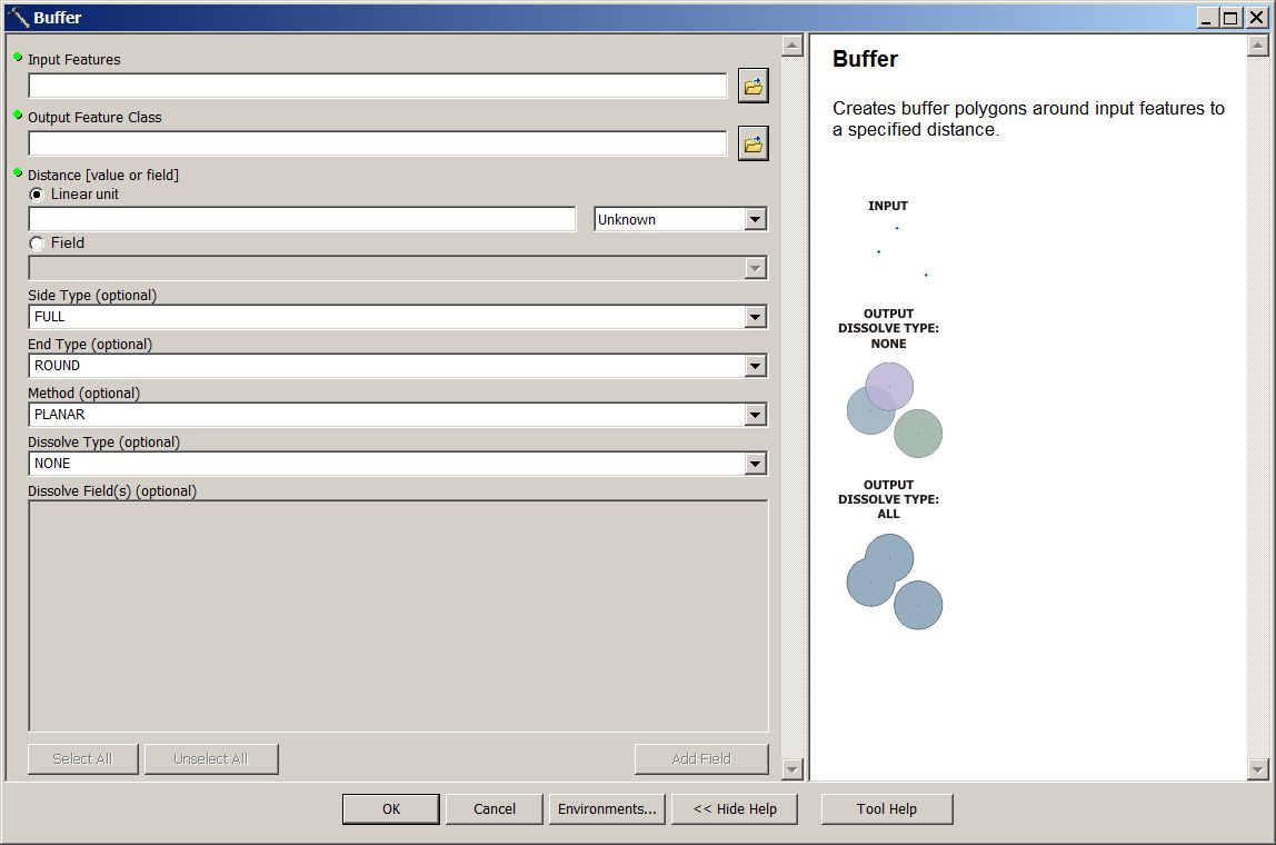
Input Features : presumably your points
Output Feature Class : what you want to call the output, usually something like MyInputName_Buffer.
Distance : either a fixed number, or if you click the filed radio button, a field containing a number for the distance. If you had another column with a distance (calculated from your "severity" perhaps), that would go here.
End Type & Method... Usually leave alone.
Dissolve : None - individual buffer polygons will be created for each input point.
- Mark as New
- Bookmark
- Subscribe
- Mute
- Subscribe to RSS Feed
- Permalink
Hello! Yes, it is in a projected coordinate system.
With selection step, I meant the selection of the Input Features in the Buffer tool. When I select my shape file, that shape file has 15 different values assigned to each of the 40 coordinates (15 different pollutants). There is no option in the buffer tool to select only one variable from the attribute table of the shape file (1 pollutant). I am not sure that that is the reason why the created buffers are not displayed, but I guess that could be a plausible reason.. Although it is also plausible that I am wrong.
Thanks again!
- Mark as New
- Bookmark
- Subscribe
- Mute
- Subscribe to RSS Feed
- Permalink
Can you give us a picture of what the attribute table looks like?
Do you have 1 point with 15 attribute columns with pollutant data in each or...
15 points on the same location each with 1 attribute of pollutant?
What are you inputting for buffer distance?
- Mark as New
- Bookmark
- Subscribe
- Mute
- Subscribe to RSS Feed
- Permalink
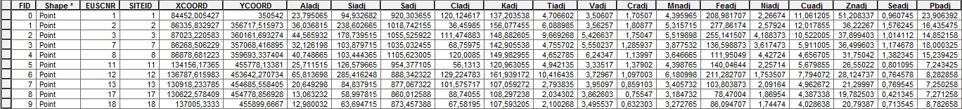
Good morning,
Please find a screenshot above. Each coordinate has 15 attribute columns assigned to it.. So far I have only tried to use 500 m as a buffer distance. Only once I know how to create these, I will start looking for ways to assign relative buffers based on the severity of pollution.
Best,
Gosia
- Mark as New
- Bookmark
- Subscribe
- Mute
- Subscribe to RSS Feed
- Permalink
Your buffer field has to be numeric. If you don't have a numeric buffer distance for each pollutant, then you simply create the desired buffer and symbolize using the pollutant of your choosing IF they all have the same buffer distance. Just trying to make sure you aren't trying to confusing symbolizing a map for a particular pollutant versus buffering by a size for a particular pollutant. I have described both cases...you decide.
- Mark as New
- Bookmark
- Subscribe
- Mute
- Subscribe to RSS Feed
- Permalink
Thank you for your reaction! So far I have only tried to create 500 m buffers, thus numeric and for each coordinate point the same. I will start playing around with different distances once I know how to create the "simple" buffers.
Best,
Gosia