- Home
- :
- All Communities
- :
- Products
- :
- Geoprocessing
- :
- Geoprocessing Questions
- :
- Re: How to change the extent values of a raster im...
- Subscribe to RSS Feed
- Mark Topic as New
- Mark Topic as Read
- Float this Topic for Current User
- Bookmark
- Subscribe
- Mute
- Printer Friendly Page
How to change the extent values of a raster image in Arcmap 10.1
- Mark as New
- Bookmark
- Subscribe
- Mute
- Subscribe to RSS Feed
- Permalink
Hi guys,
I have two raster images that cover the same area but their extents are different because one of the two does not have a projection. How can I copy the extents of the projected raster to unprojected raster so that both images can be overlaid each other? I imported the projection but cannot import the extends. Is there a tool in Arcgis that I can use to do that?
Solved! Go to Solution.
Accepted Solutions
- Mark as New
- Bookmark
- Subscribe
- Mute
- Subscribe to RSS Feed
- Permalink
If the two images were in the same projection originally, and covered exactly the same extents, it may be possible to line them up by copying the World File from the working one and then renaming the copy to the file name of the non-working one. For example, for a tif image, copy goodtif.tfw and rename it to the other rasters name (and keep the .tfw extension). Then open a brand new ArcMap session and load them both in. Note that you definitely need to start a new session - the addition of a world file won't help for images already loaded into ArcGIS.
However, the liklihood that the images are exactly the same is a longshot. More likely Georeferencing will need to be employed to get the two aligned.
One thing that would be helpful to know in terms of troubleshooting this is the raster file type of the imagery you have. Are they tiffs, sids, jpg, or another of the many image formats? This information is helpful to know as different rasters have different properties. For example, some rasters also can have the extent embedded in the raster itself, which can override the world file.
Chris Donohue, GISP
- Mark as New
- Bookmark
- Subscribe
- Mute
- Subscribe to RSS Feed
- Permalink
Hi Mike,
You will want to georeference the raster. Take a look at the following link for the steps on how to do this:
- Mark as New
- Bookmark
- Subscribe
- Mute
- Subscribe to RSS Feed
- Permalink
Thanks Jake but the images still do not overlay perfectly each other after georeferencing.
- Mark as New
- Bookmark
- Subscribe
- Mute
- Subscribe to RSS Feed
- Permalink
As Jake said, you may have to georeference the raster that doesn't have a coordinate system definition.
However, is it georeferenced (has real world coordinates) already or does it have raw image values (extent is the number of cells like 0 to 1000)?
If it does have real world coordinates, but you just don't know what the coordinate system is, you could try posting the raster's extents plus the area it represents (county, city, lat/lon, etc.) and perhaps someone could offer some suggestions.
Melita
- Mark as New
- Bookmark
- Subscribe
- Mute
- Subscribe to RSS Feed
- Permalink
Hi Melita,
The unprojected image is in gif format. I have attached the extent values of this gif image. 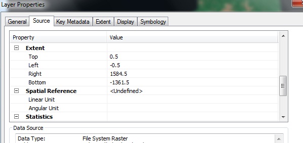
- Mark as New
- Bookmark
- Subscribe
- Mute
- Subscribe to RSS Feed
- Permalink
If the two images were in the same projection originally, and covered exactly the same extents, it may be possible to line them up by copying the World File from the working one and then renaming the copy to the file name of the non-working one. For example, for a tif image, copy goodtif.tfw and rename it to the other rasters name (and keep the .tfw extension). Then open a brand new ArcMap session and load them both in. Note that you definitely need to start a new session - the addition of a world file won't help for images already loaded into ArcGIS.
However, the liklihood that the images are exactly the same is a longshot. More likely Georeferencing will need to be employed to get the two aligned.
One thing that would be helpful to know in terms of troubleshooting this is the raster file type of the imagery you have. Are they tiffs, sids, jpg, or another of the many image formats? This information is helpful to know as different rasters have different properties. For example, some rasters also can have the extent embedded in the raster itself, which can override the world file.
Chris Donohue, GISP
- Mark as New
- Bookmark
- Subscribe
- Mute
- Subscribe to RSS Feed
- Permalink
Thanks Chris for the tip. I could give the exact extent values of the projected image to unprojected gif image manually in Erdas Imagine but just could not find a way to do it in Arcmap. Thanks for your help though.
- Mark as New
- Bookmark
- Subscribe
- Mute
- Subscribe to RSS Feed
- Permalink
You can do that by moving the image to Contents Table and then clicking the properties and changing the extent.