- Home
- :
- All Communities
- :
- Products
- :
- Geoprocessing
- :
- Geoprocessing Questions
- :
- Re: How to calculate intermediate polygon between ...
- Subscribe to RSS Feed
- Mark Topic as New
- Mark Topic as Read
- Float this Topic for Current User
- Bookmark
- Subscribe
- Mute
- Printer Friendly Page
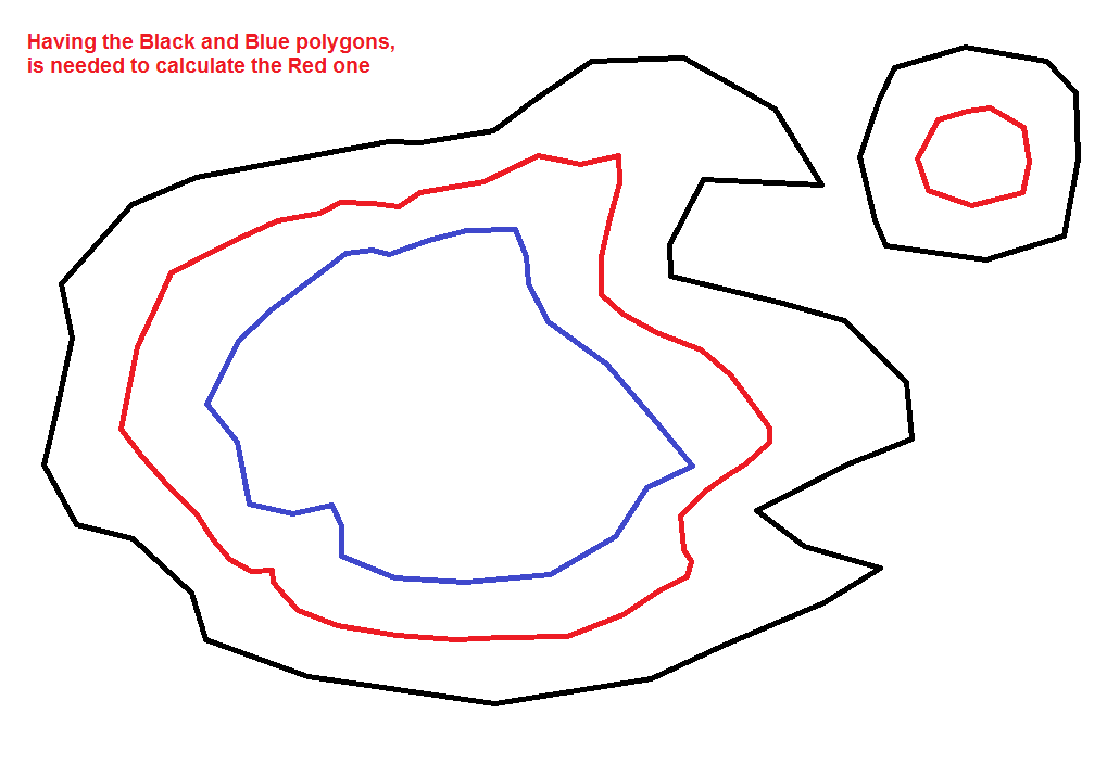
How to calculate intermediate polygon between two polygons using ArcGIS
- Mark as New
- Bookmark
- Subscribe
- Mute
- Subscribe to RSS Feed
- Permalink
Solved! Go to Solution.
Accepted Solutions
- Mark as New
- Bookmark
- Subscribe
- Mute
- Subscribe to RSS Feed
- Permalink
Just a quick workflow idea that could be tried if you have access to Spatial Analyst or 3D Analyst. Untested, but I think this could work. It would need to be fleshed out with the specific processes (this is just the basic process).
- Convert the polygons to lines
- Combine into one feature class (if not already)
- Add an integer field called "Elevation"
- Populate one line with zero and the other with 100
- Convert the lines to a surface (raster)
- Contour the surface, specifying an elevation of 50. This will essentially produce the result you are seeking.
- Convert to vector, then Convert the lines back to polygons.
Chris Donohue, GISP
- Mark as New
- Bookmark
- Subscribe
- Mute
- Subscribe to RSS Feed
- Permalink
Not clear... you say you want to do this in QGIS ...
perhaps try their discussion group https://gis.stackexchange.com/
- Mark as New
- Bookmark
- Subscribe
- Mute
- Subscribe to RSS Feed
- Permalink
Sorry, I have edited question now.
- Mark as New
- Bookmark
- Subscribe
- Mute
- Subscribe to RSS Feed
- Permalink
Just a quick workflow idea that could be tried if you have access to Spatial Analyst or 3D Analyst. Untested, but I think this could work. It would need to be fleshed out with the specific processes (this is just the basic process).
- Convert the polygons to lines
- Combine into one feature class (if not already)
- Add an integer field called "Elevation"
- Populate one line with zero and the other with 100
- Convert the lines to a surface (raster)
- Contour the surface, specifying an elevation of 50. This will essentially produce the result you are seeking.
- Convert to vector, then Convert the lines back to polygons.
Chris Donohue, GISP
- Mark as New
- Bookmark
- Subscribe
- Mute
- Subscribe to RSS Feed
- Permalink
Fantastic idea! Could you tell me which tools are the best to use to create the surface and which one to create 50m elevation Contour?
- Mark as New
- Bookmark
- Subscribe
- Mute
- Subscribe to RSS Feed
- Permalink
Just edit the polygon using Edit Toolbar, select the smaller/inner polygon. Once selected under Editor Toolbar select CLIP. You have a choice to Preserve or Discard the area of intersection. Discard it and calculate the area Easy Peazy
