- Home
- :
- All Communities
- :
- Products
- :
- Geoprocessing
- :
- Geoprocessing Questions
- :
- Geoprocessing Tool (workflow) to identify suitable...
- Subscribe to RSS Feed
- Mark Topic as New
- Mark Topic as Read
- Float this Topic for Current User
- Bookmark
- Subscribe
- Mute
- Printer Friendly Page
Geoprocessing Tool (workflow) to identify suitable parcels for second building
- Mark as New
- Bookmark
- Subscribe
- Mute
- Subscribe to RSS Feed
- Permalink
Hi there,
I'm wondering if there is a geoprocessing tool which could assist me with identifying (on a high level) suitable parcels for subdividing.
Basically, I have parcels and buildings and would like to identify parcels which would have enough space for a second (or third,...) building on it.
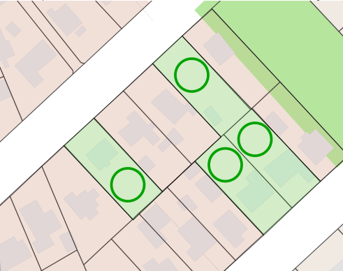
e.g. the four parcels below (green) would have enough space for a second building (green circle).
Does anyone have something in mind?
Cheers,
Marco
Solved! Go to Solution.
Accepted Solutions
- Mark as New
- Bookmark
- Subscribe
- Mute
- Subscribe to RSS Feed
- Permalink
Alright, the tool was not quite what I was looking for, since this would result in areas which would be to small (or thin) for a potential additional building.
However, I had a workaround to identify areas with a diameter ≥ X meters :
- Negative buffer (where buffer distance = - X/2) of the parcels
- Positive buffer (where buffer distance = X/2) of the buildings
- Erase buildings buffer from parcel buffer
- Positive buffer (where buffer distance = X/2) to remaining area
This gave me exactly what I wanted to have 
Cheers,
Marco
- Mark as New
- Bookmark
- Subscribe
- Mute
- Subscribe to RSS Feed
- Permalink
Hi Marco Poetsch,
You can use Symmetrical Difference from Analysis tools.
Features or portions of features in the input and update features that do not overlap will be written to the output feature class. The output gives a polygon (parcel - building) with calculated areas. Then you can determine if each output parcel has enough area for another building based on your criteria.
Symmetrical Difference (Analysis)—ArcGIS Pro | Documentation
I hope that gives an idea.
- Mark as New
- Bookmark
- Subscribe
- Mute
- Subscribe to RSS Feed
- Permalink
sounds promising, Mehdi.
I'll give it a try and let you know
Otherwise I'll go with plan B and make something in the Model Builder
Cheers,
Marco
- Mark as New
- Bookmark
- Subscribe
- Mute
- Subscribe to RSS Feed
- Permalink
Alright, the tool was not quite what I was looking for, since this would result in areas which would be to small (or thin) for a potential additional building.
However, I had a workaround to identify areas with a diameter ≥ X meters :
- Negative buffer (where buffer distance = - X/2) of the parcels
- Positive buffer (where buffer distance = X/2) of the buildings
- Erase buildings buffer from parcel buffer
- Positive buffer (where buffer distance = X/2) to remaining area
This gave me exactly what I wanted to have
Cheers,
Marco