Turn on suggestions
Auto-suggest helps you quickly narrow down your search results by suggesting possible matches as you type.
Cancel
- Home
- :
- All Communities
- :
- Products
- :
- Geoprocessing
- :
- Geoprocessing Questions
- :
- Re: Feature does not correspond with base map
Options
- Subscribe to RSS Feed
- Mark Topic as New
- Mark Topic as Read
- Float this Topic for Current User
- Bookmark
- Subscribe
- Mute
- Printer Friendly Page
Feature does not correspond with base map
Subscribe
2993
2
03-31-2014 04:13 AM
03-31-2014
04:13 AM
- Mark as New
- Bookmark
- Subscribe
- Mute
- Subscribe to RSS Feed
- Permalink
- Report Inappropriate Content
Hi,
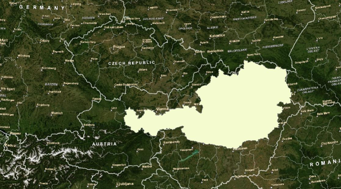
I am working on a LULC Project in Austria and got several shapefiles from different sources. I really have issues to get them together for Analysis. The attached sreenshot sums it up pretty good. The borders of Austria lie about 500km to far east. I am using a projected coordinate System (MGI_M31) for both, the data Frame and the shapefile. I guess ist some Kind of banality but im really stuck here.
Thanks
2 Replies
03-31-2014
05:16 AM
- Mark as New
- Bookmark
- Subscribe
- Mute
- Subscribe to RSS Feed
- Permalink
- Report Inappropriate Content
Hi Sol and thanks for your answer.
I already used the define projection tool with no satisfying result. I always changed the coordinate system in the catalog which has the same result if I got it right. What you refer to as raster image is the basemap provided by ArcMAp. so I suppose it is displayed as defined in the data frame properties???
I already used the define projection tool with no satisfying result. I always changed the coordinate system in the catalog which has the same result if I got it right. What you refer to as raster image is the basemap provided by ArcMAp. so I suppose it is displayed as defined in the data frame properties???
03-31-2014
08:54 AM
- Mark as New
- Bookmark
- Subscribe
- Mute
- Subscribe to RSS Feed
- Permalink
- Report Inappropriate Content
Andreas,
Try redefining (not reprojecting) the data to MGI Austria GK Central. Its false easting value is 0, while M31 uses 450km. You should also set a geographic (datum) transformation between MGI and WGS84. Try MGI_To_WGS_1984_3.
Basemaps from Esri almost all use WGS 1984 Web Mercator (Auxiliary Sphere).
Melita