- Home
- :
- All Communities
- :
- Products
- :
- Geoprocessing
- :
- Geoprocessing Questions
- :
- Re: Extracting specific roads from raster image us...
- Subscribe to RSS Feed
- Mark Topic as New
- Mark Topic as Read
- Float this Topic for Current User
- Bookmark
- Subscribe
- Mute
- Printer Friendly Page
Extracting specific roads from raster image using ArcGIS Desktop
- Mark as New
- Bookmark
- Subscribe
- Mute
- Subscribe to RSS Feed
- Permalink
I want to create a line shapefiles of white roads from the raster file (screenshot1) using ArcGIS: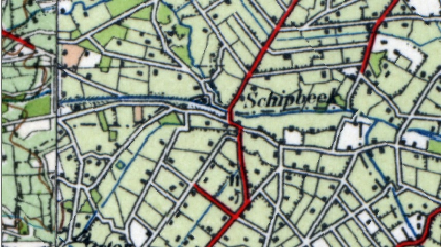
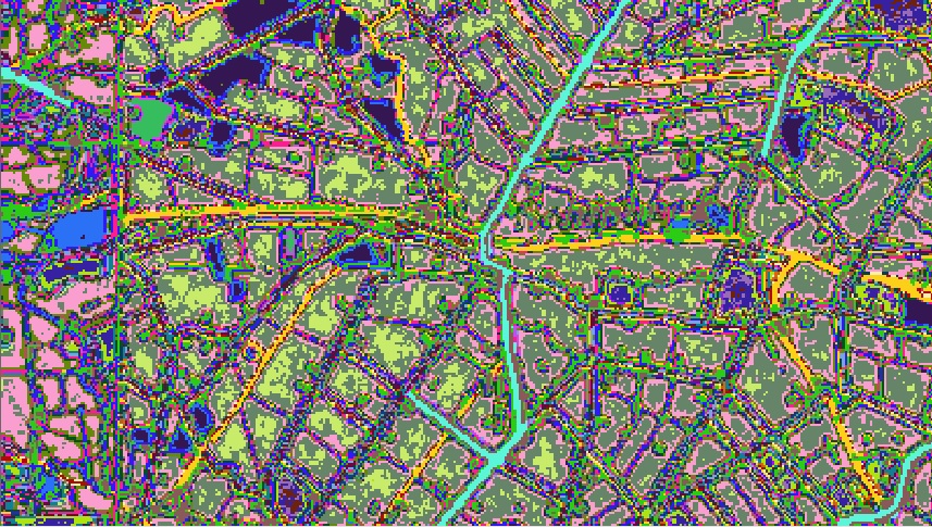
My idea is to use ArcScan toolbar, but first of all I need to classify roads pixels values from raster. For that I have used ISO Unsupervised classification tool with a number of 30 classes. The results are not good for me because I got the unclear pixel values which are unusable for ArcScan vectorisation (screenshot2):
Of course, if I have a clear pixels defining the roads I will use Reclassify tool to filter get just two pixel values (one which I need and one which don`t). Now I need to know is there any way to solve my problem?
- Mark as New
- Bookmark
- Subscribe
- Mute
- Subscribe to RSS Feed
- Permalink
For a scanned map like this one, digitization is the best way.
As rightly pointed by you, ArcScan will work on 1-bit image. Also Supervised/Unsupervised classifications are not good for scanned images.
Think Location
- Mark as New
- Bookmark
- Subscribe
- Mute
- Subscribe to RSS Feed
- Permalink
I know that a digitization is the best way and according to this maybe the only good solution. I have tried to find out some more automatically solution...
- Mark as New
- Bookmark
- Subscribe
- Mute
- Subscribe to RSS Feed
- Permalink
If the roads can be isolated, but they are too wide, try Thin.... prior to converting to polylines works in some instances, but that in conjunction or arcscan and manual digitizing will get it all together
- Mark as New
- Bookmark
- Subscribe
- Mute
- Subscribe to RSS Feed
- Permalink
In case this is a place in the Netherlands (which could be the case based on the Dutch text "Schipbeek"), you could go to the PDOK site and download the vector dataset instead of trying to convert the raster data into vector data:
https://www.pdok.nl/nl/producten/pdok-downloads/basis-registratie-topografie/topnl/topnl-actueel
- Mark as New
- Bookmark
- Subscribe
- Mute
- Subscribe to RSS Feed
- Permalink
Good suggestion but my map is from the year of 1930.so a lot of thing was changed until now. If you have some source where I can get historic data that would be great.
- Mark as New
- Bookmark
- Subscribe
- Mute
- Subscribe to RSS Feed
- Permalink
I'm afraid that the history available doesn't go back further then 2012:
https://www.pdok.nl/nl/producten/pdok-downloads/basisregistratie-topografie/topnl/topnl-historie
If the attached image represents the actual quality of the scan that you have:
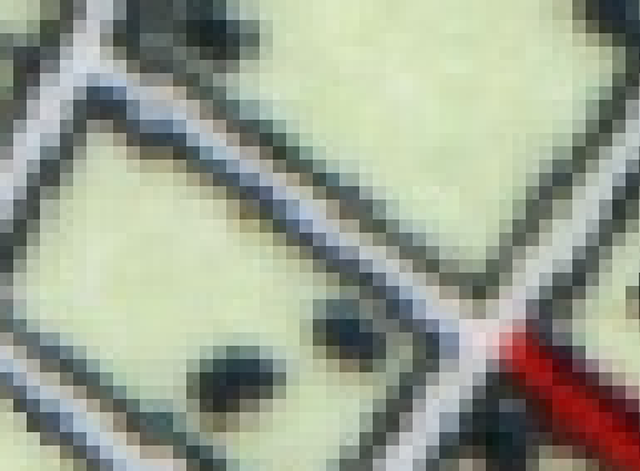
You will have to deal with the spectral mixing in the scan and the anti aliasing effect. You don't simply have white for the road and black for the border, but a range of grey colors which will make it more complex to automagically convert it to a correct vector representation of the roads.
I noticed that the NWB (National Wegen Bestand) is available in WFS (earliest edition is 2006): https://data.overheid.nl/data/dataset/nationaal-wegen-bestand-wegen-hectopunten-2006
Or maybe you could contact Rijkswaterstaat directly asking if they have a version of the roads for your specific area from 1930: https://www.rijkswaterstaat.nl/formulieren/contactformulier-nationaal-wegenbestand.aspx
- Mark as New
- Bookmark
- Subscribe
- Mute
- Subscribe to RSS Feed
- Permalink
Thanks a lot. Anyway I will start digitizing this old scanned map. That is the only good solution.
- Mark as New
- Bookmark
- Subscribe
- Mute
- Subscribe to RSS Feed
- Permalink
Yes, Thin is a very good solution, but the main problem here is to isolate roads pixels...
- Mark as New
- Bookmark
- Subscribe
- Mute
- Subscribe to RSS Feed
- Permalink
Jayanta's suggestion... some image classification is in order, ... the road colour is off-white hopefully sufficiently different from other white values to give it a good chance of being recognized and separated. It would be worth a shot, then proceed to the semi-automated methods...
Thinning will work, but it needs something to thin as noted