- Home
- :
- All Communities
- :
- Products
- :
- Geoprocessing
- :
- Geoprocessing Questions
- :
- Re: Distance measurements from point to point alon...
- Subscribe to RSS Feed
- Mark Topic as New
- Mark Topic as Read
- Float this Topic for Current User
- Bookmark
- Subscribe
- Mute
- Printer Friendly Page
Distance measurements from point to point along a line feature class
- Mark as New
- Bookmark
- Subscribe
- Mute
- Subscribe to RSS Feed
- Permalink
I am running ArcMap 10.2.2 on a Windows 7 machine.
I am wondering if it is possible to measure the distance from multiple points along a line feature class back to a single point.
Essentially I have a layer of points that are all routed back to a single location in another layer through a line feature class. I would like a way to automate an output that gives me the measurement from each point back to the single point. There are line segments that would need to be accounted for in the path for multiple points at times.
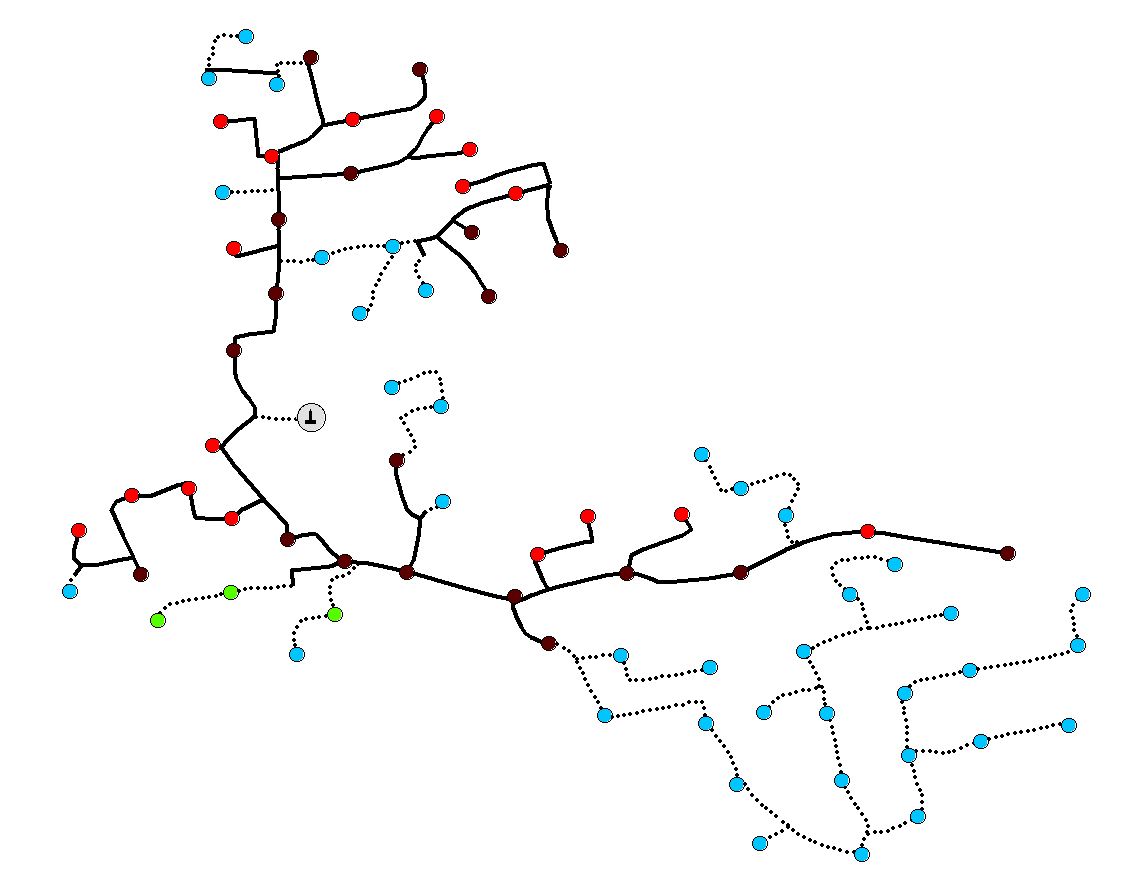
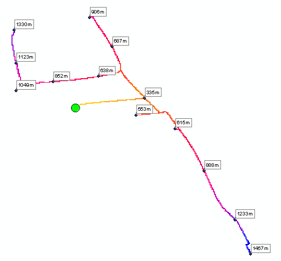
The below image gives an example of the three feature classes that I have. The one contains multiple points that are all routed back to a single "hub" location via a line feature class. I need an output that measures the line distance back to that "hub" location from each individual point feature.
- Mark as New
- Bookmark
- Subscribe
- Mute
- Subscribe to RSS Feed
- Permalink
Here's my five minute solution:
1.) Add and calculate a field in your fiber feature class to equal 1 for all rows.
2.) Convert to raster (requires Spatial Analyst, I believe), using new column as value. Now have fiber raster layer, all with value = 1.
3.) Run Cost Distance tool (requires Spatial Analyst), using new raster as cost surface and hub as source.
4.) Extract resulting cost distance values to node points. This will only transfer distances to nodes if they happen to fall on the fiber raster. If not, need to edit nodes so they fall on raster and rerun.
This was done somewhat naively, not knowing if there are geometrical consequences calculating continuous distances between square pixels, but the values seem reasonable.
- Mark as New
- Bookmark
- Subscribe
- Mute
- Subscribe to RSS Feed
- Permalink
This does seem to do what I want, but as you say, I'm not sure if the pixelation will throw off the exact measurements. Since these values are thrown into a cost model, these values will need to be fairly accurate. In the example above, I doubt this method would create much of a concern, but I do encounter networks with upwards of 50-60 miles of fiber. If there is any sort of skewing from the pixelation, I'm sure it would be a problem with that much fiber distance.
Thanks so much for the proposed method, though! 
- Mark as New
- Bookmark
- Subscribe
- Mute
- Subscribe to RSS Feed
- Permalink
If the results are to been thrown into a cost distance/path model, then they should have been in raster format in the first place. Also, that is just one aspect of path analysis, if you want to incorporate difficulty in traversing terrain, then consider using things like slope etc, and using path distance rather than simple cost distance since you can account for direction of travel as well
As well, the results may be a bit better with regard to distance estimates if you convert your resultant paths to polylines with the simplify option. In the big picture of things, it will be the cell size that controls how well the path is estimated.
- Mark as New
- Bookmark
- Subscribe
- Mute
- Subscribe to RSS Feed
- Permalink
The cost model I refer to is an Excel workbook that takes overall footage values and runs them through various calculations to account for fiber slack and whatnot. The cost model encompasses 188 lines of key metric input data (output from ArcMap), and has about 10 tabs, so I can't even begin to explain all the calculations that are applied .
Also, I just checked and we don't have the Spatial Analyst extension  .
.
- Mark as New
- Bookmark
- Subscribe
- Mute
- Subscribe to RSS Feed
- Permalink
Why doen't your organization spend the cash and buy the Network Analyst or examine geometric networks ? These are the tools designed to deal with these sorts of issues. And if your reach is broad, the initial investments will be quickly recovered. There are well designed tools out there that will handle the spatial problems and allow you to create 'costs' as part of the network design leaving any remainder for the spreadsheet realm.
- Mark as New
- Bookmark
- Subscribe
- Mute
- Subscribe to RSS Feed
- Permalink
As a company, they don't know GIS, thus they don't know the options available. I think they were a little hesitant to drop the investment of three licenses for ArcGIS Standard and the ArcGIS Server Package, so we limited the "extras" that we proposed.
For myself, this is my first post-grad job so I am pretty new to the GIS workforce, and definitely new to the telecommunications world. I am still learning new facets of GIS that pertain to telecommunications.
When I first started my job here I enabled the transition from a sub-par in-house GIS tool that was never fully developed and virtually only allowed you to draw features that had no attribute values whatsoever to the ArcGIS Platform. I designed a template map and SDE geodatabase structure comprising of various feature classes, domain connections, and relationship classes to use for all of our work, which is still changing frequently as we throw ideas back and forth and test different methodologies.
The problem that we have been having is that one particular region wants a fiber matrix (distance from each node point back to the hub) for each project. We have been doing this manually by simply selecting all segments to a node, copy selected from the table, and paste them into Excel to sum the lengths. This works, but as you can imagine, it is more time consuming than we'd like for it to be. I've researched the various Route tools in the Linear Referencing Tools toolbox, but I don't think any of them do what I need. The methods explained above do seem to be on the right track to what we need, though.
I am going to research the geometric networks link you gave above. If you have any other tidbits of knowledge regarding the telecommunications realm, feel free to share them. I'm always open to new knowledge .
- « Previous
- Next »
- « Previous
- Next »