- Home
- :
- All Communities
- :
- Products
- :
- Geoprocessing
- :
- Geoprocessing Questions
- :
- Re: Density points to equally divided polygons
- Subscribe to RSS Feed
- Mark Topic as New
- Mark Topic as Read
- Float this Topic for Current User
- Bookmark
- Subscribe
- Mute
- Printer Friendly Page
Density points to equally divided polygons
- Mark as New
- Bookmark
- Subscribe
- Mute
- Subscribe to RSS Feed
- Permalink
How do I convert a point layer into multiple polygons? Ideally each polygon would take into account the weight of each point.
EDIT: Just to clarify my intention. I have a layer with 2,000 points. I want to end up with a polygon layer which has three polygons where each polygon covers the area of 1/3 of those points.
Message was edited by: Roberto DeDeus
- Mark as New
- Bookmark
- Subscribe
- Mute
- Subscribe to RSS Feed
- Permalink
You could Using graduated symbols—Help | ArcGIS for Desktop
or you could buffer each point based on the field Buffer—Help | ArcGIS for Desktop
And for density you'll want
Point Density—Help | ArcGIS for Desktop
or
Kernel Density—Help | ArcGIS for Desktop
EDIT:
i missed Using proportional symbols—Help | ArcGIS for Desktop
- Mark as New
- Bookmark
- Subscribe
- Mute
- Subscribe to RSS Feed
- Permalink
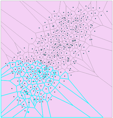
a voronoi diagram will subdivide space from input points.
Examining local variation—Help | ArcGIS for Desktop in geostatistical analyst
Create Thiessen Polygons—Help | ArcGIS for Desktop with an advanced license
or Triangulation tools... http://www.arcgis.com/home/item.html?id=6e9bc6cbf93d4939b2eb04ff8519be47
my humble but free offering
- Mark as New
- Bookmark
- Subscribe
- Mute
- Subscribe to RSS Feed
- Permalink
Dan, that's a great Thiessen tool you uploaded to ArcGIS Online! Thanx for sharing!
- Mark as New
- Bookmark
- Subscribe
- Mute
- Subscribe to RSS Feed
- Permalink
Well your modified question, is indeed different... perhaps Aggregate Points—Help | ArcGIS for Desktop
might be a first step, although getting to the target of 3 polygons and 3 only may be a bit out of its realm. But you will need an Advanced license. And perhaps Aggregate Polygons—Help | ArcGIS for Desktop could be used in association with it after the initial clustering
- Mark as New
- Bookmark
- Subscribe
- Mute
- Subscribe to RSS Feed
- Permalink
Can you provide a picture of what you hope to accomplish? There are (almost) an infinite number of solutions to this problem the way I see it.
- Mark as New
- Bookmark
- Subscribe
- Mute
- Subscribe to RSS Feed
- Permalink
A rather manual way (and using an Advanced license) could be:
- Create Thiessen Polygons based on the input points
- Generate a Near table from the points to the polygons limiting the maximum number of closest matched to a third of the total number of points and not limiting the search distance (this will create a huge table in your case using 2000 points)
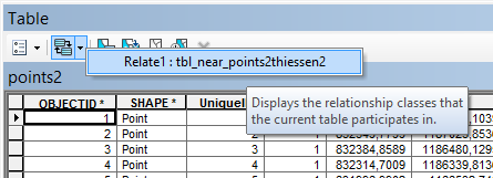
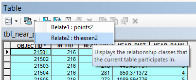
- From the table, create two relates. One towards the points using the IN_FID matching the OBJECTID and one towards the thiessen polygons using the NEAR_FID matching the OBJECTID of the polygons.
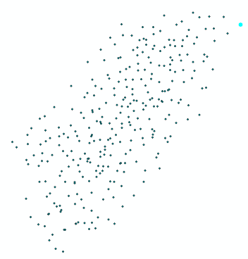
- In the point featureclass, select a single extreme point:
- Open the attribute table of the points and use the Relate to select the nearest polygons:
- In the Near table use the relate to the polygons to select the corresponding Thiessen polygons:
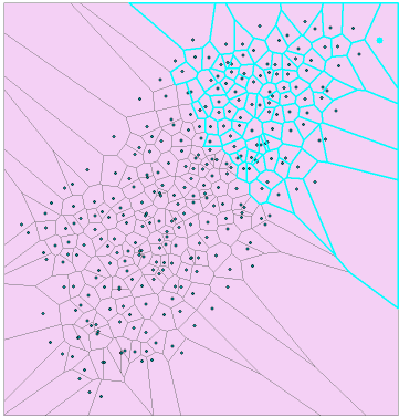
- Add a new numeric field to the polygons and fill the field with the value 1 (group 1)
- Do the same based on an extreme point located at the opposite of the area (assign value 3)
- Select the features where the new goup field IS NULL
- Fill that selection with value 2:

- You can make the result a bit more presentable by clipping it with the area of interest or using the Minimum Bounding Geometry tool to create a ConvexHull, buffer that with a representative distance and clip it. Dissolve the polygons by the group field:
This is very manual and you may have a problem when using 2000 points. In my case using 300 point the number of records in the Near table was 300 * 100 = 30000. In you case it will be 2000 * 667 = 1334000.
I'm sure there must a nice algoritm implemented in Python to do the job...
- Mark as New
- Bookmark
- Subscribe
- Mute
- Subscribe to RSS Feed
- Permalink
BTW, it would be nice if the Grouping Analysis—Help | ArcGIS for Desktop would do the job, but it has no option to divide into equal groups.
Maybe the Location-allocation analysis—Help | ArcGIS for Desktop could be helpful?