- Home
- :
- All Communities
- :
- Products
- :
- Geoprocessing
- :
- Geoprocessing Questions
- :
- Datum shift
- Subscribe to RSS Feed
- Mark Topic as New
- Mark Topic as Read
- Float this Topic for Current User
- Bookmark
- Subscribe
- Mute
- Printer Friendly Page
- Mark as New
- Bookmark
- Subscribe
- Mute
- Subscribe to RSS Feed
- Permalink
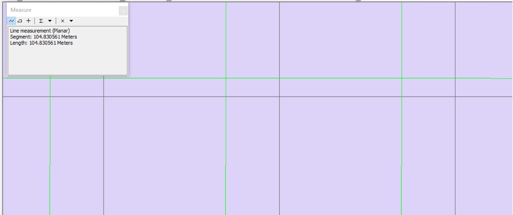
I've just downloaded some DEM rasters off of the USGS National Map for a location in Northern California(near Willows). The rasters are derived from LiDAR collected and processed by Quantum Spatial. In addition to the raster DEMs I downloaded the deliverable report from Quantum Spatial which includes a shapefile of the LiDAR tile grid (1km x 1 km squares. When I load these data into ArcMap 10.6.1 the data do not align. Both data sets are in the same projection (NAD_1983_2011_Contiguous_USA_Albers) using the same datum (D_NAD_1983_2011). Specifically the raster files are offset just over 300 m west, and just over 100 m (104) north of the corresponding grid in the shapefile. The green lines in the image below are the foot print for each raster and the gray lines represent the Quantum Spatial grid.
It looks like the datum for the raster files is off, but I'm not sure how to correct it. A colleague suggested using a different transformation in the dataframe, but I've tried all of them with no luck.
Any guidance?
Cheers!
-Adam
Solved! Go to Solution.
Accepted Solutions
- Mark as New
- Bookmark
- Subscribe
- Mute
- Subscribe to RSS Feed
- Permalink
I tried defining the projection of the raster to NAD_1983_Contiguous_USA_Albers' (previously defined as NAD_1983_2011_Contiguous_USA_Albers) and the raster seemed to shift into the correct location.
- Mark as New
- Bookmark
- Subscribe
- Mute
- Subscribe to RSS Feed
- Permalink
I tried defining the projection of the raster to NAD_1983_Contiguous_USA_Albers' (previously defined as NAD_1983_2011_Contiguous_USA_Albers) and the raster seemed to shift into the correct location.
- Mark as New
- Bookmark
- Subscribe
- Mute
- Subscribe to RSS Feed
- Permalink
Just to further document this, I had the same issue. The attached screenshot shows the spatial reference information from ArcPro for the correct definition (EPSG 6350) on the left, and the incorrectly delivered SRS on the right. Note that the they look identical except for the standard_parallel_1,
29.5 and 29.3
respectively.
Defining the projection to EPSG 6350 solved the issue for me as well.
- Mark as New
- Bookmark
- Subscribe
- Mute
- Subscribe to RSS Feed
- Permalink
Here's an explanation of the issue. It's a bug. Is That Georeferencing Really Wrong? (wordpress.com)
- Mark as New
- Bookmark
- Subscribe
- Mute
- Subscribe to RSS Feed
- Permalink
Hi, if USGS have gone to the trouble of maintaining geodetic control for the master LiDAR data and say the raster is in the 2011 realization I'm guessing the shapefile is the dataset to investigate and don't assume they got the datum wrong.
This thread NAD83 vs. NAD83(2011) mentions a transformation to use (NAD_1983_HARN_To_NAD_1983_2011) if the shapefile is in the original NAD 83 datum so try that first.
- Mark as New
- Bookmark
- Subscribe
- Mute
- Subscribe to RSS Feed
- Permalink
I actually shot GPS locations on the ground where these data are located, and they only align when I define the rasters as NAD83. I'll give that transformation a try though.
Cheers!