- Home
- :
- All Communities
- :
- Products
- :
- Geoprocessing
- :
- Geoprocessing Questions
- :
- Re: Data-Driven Pages Export to PDF with Custom Zo...
- Subscribe to RSS Feed
- Mark Topic as New
- Mark Topic as Read
- Float this Topic for Current User
- Bookmark
- Subscribe
- Mute
- Printer Friendly Page
Data-Driven Pages Export to PDF with Custom Zoom
- Mark as New
- Bookmark
- Subscribe
- Mute
- Subscribe to RSS Feed
- Permalink
In an MXD with data-driven pages enabled, I often zoom to a custom extent on a given page. As long as I don't refresh the DD pages, the custom extents are maintained. I used to export to PDF after setting all of those extents, but in ArcGIS Advanced version 10.2.2.3552, it saves the default data-driven extents instead. This occurs whether I export all pages or just the current page. Export to JPG works as expected, so my workaround has been to export each page individually to a JPG, then combine files in Adobe. Has anyone else had this problem?
Solved! Go to Solution.
Accepted Solutions
- Mark as New
- Bookmark
- Subscribe
- Mute
- Subscribe to RSS Feed
- Permalink
Ok, understood that part. Did you go through the link? There it is mentioned that it could be done till 9.3.1. Also they looking into integrating the same in latest versions. Here is another link if you are interested in Python.
ttps://geonet.esri.com/message/295210#295210
- Mark as New
- Bookmark
- Subscribe
- Mute
- Subscribe to RSS Feed
- Permalink
Hi Mynsberge,
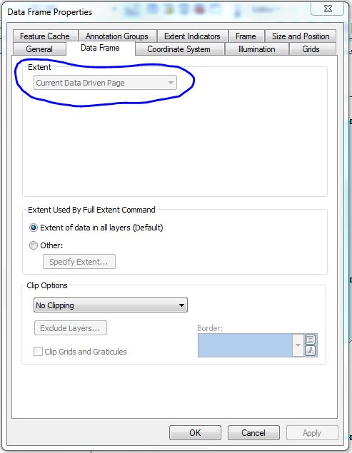
If I understand you correctly you want the custom extent in PDF export. I tried to test it but when you enable DDP on a feature layer extents are taken from data driven page.(In data frame properties)
So while exporting map there is nothing we can do to change the extent I believe.
https://community.esri.com/message/265362#265362
Testing Environment
Windows 7 Enterprise
ArcMap 10.2.2.3552
- Mark as New
- Bookmark
- Subscribe
- Mute
- Subscribe to RSS Feed
- Permalink
I should have specified that I'm changing scale/extent by using the Zoom In or Zoom Out tool on individual pages in Data View rather than in the Data Frame Properties. If you do this, you should be able to recreate the differences between a JPG export (which will preserve the new scale/extent for a given page) and the PDF export (which will return to the default data-driven page scale/extent).
- Mark as New
- Bookmark
- Subscribe
- Mute
- Subscribe to RSS Feed
- Permalink
Ok, understood that part. Did you go through the link? There it is mentioned that it could be done till 9.3.1. Also they looking into integrating the same in latest versions. Here is another link if you are interested in Python.
ttps://geonet.esri.com/message/295210#295210
- Mark as New
- Bookmark
- Subscribe
- Mute
- Subscribe to RSS Feed
- Permalink
You are correct. I had been using Python when I last tried to do this, but had not wanted to use Python this time because of the time to look up and specify PDF colorspace and other customizations in Python.